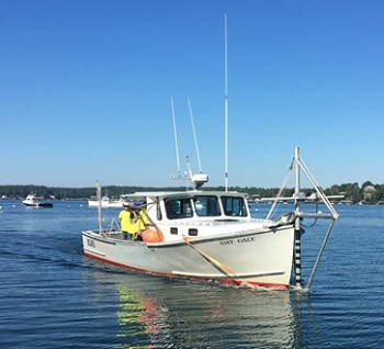
The F/V Amy Gale has been converted to a survey vessel to collect bathymetry (depth) and seafloor hardness information using a bow-mounted multibeam echosounder.
Credit: MCMI.
Introduction
The Maine Coastal Mapping Initiative (MCMI) uses state-of-the-art technology to collect hydrographic quality bathymetry and information about seafloor sediment. We further investigate the seafloor environment using underwater video and by collecting samples to identify the sediment type and catalogue the animals that live there. Our team is comprised of experienced research scientists, up and coming professionals at the beginning of their careers, and students and recent graduate interns who learn from hands-on research and data analysis. We encourage our team to explore and learn through different aspects of field and lab work, fostering a collaborative partnership among people with different areas of expertise.
In Maine, most of our existing seafloor maps were generated by dropping lead lines to the ocean bottom to estimate the depth of the overlying water column. In the 1980s and 1990s, the Maine Geological Survey (MGS) in collaboration with the University of Maine used side-scan sonar and sub-bottom profiling to map small portions of the seafloor, and collected sediment and core samples to ground truth those readings. These data were used to improve bathymetric maps and to model the composition of the seafloor along the entire coast of Maine.
Since 2014, MCMI has used a multibeam echosounder to collect hydrographic quality bathymetry to further improve maps of the region, as well as provide seamless information about the hardness of the seafloor (a proxy for eafloor sediment). To supplement these depth and hardness data and improve our understanding of marine habitat, we have collected water column and seafloor water quality data, surficial sediment samples, seafloor video, and benthic fauna information. These methods, while generally standard among different MCMI projects, have the power to answer multiple research and management questions and serve various project goals. For more information about what we use these data for, please visit the MCMI Home Page or the menu (above, left) for links to various program reports and highlights.
MCMI collects new seafloor data aboard the F/V Amy Gale, a former lobster boat converted to a survey vessel and contracted to the Maine Coastal Program. The Amy Gale is outfitted with a Konsberg EM2040C transducer, motion reference unit (MRU), AML MicroX surface sound speed probe, and dual GNSS antennas are pole-mounted to the bow. Surveys are performed to meet the requirements for NOAA hydrographic standards. An observer is on board during all data acquisition to collect observation data for marine mammals that are used to create hotspot maps.
MCMI's grab sampling efforts collect information from a wide range of benthic habitats to inform seafloor sediment interpretations of backscatter data and to evaluate correlations between the physical conditions of the seafloor with the organisms living there. Grab sampling is performed using a platform modeled after the USGS mini SEABOSS for sediment samples and grain size analysis, epifauna and infauna identification and quantification, and collection of water column measurements of temperature, salinity, pH, dissolved oxygen and chlorophyll concentrations. This sampler also collects underwater video to document seafloor sediment and organisms living on the surface. By collecting sediment samples that ground-truth backscatter data, we can create derivative products including high resolution seamless sediment and geomorphic maps. Using an innovative statistical modeling approach, we also use these data to create benthic habitat maps using sediment type and common species assemblages. Further, a key innovation in our work includes a novel image and video analysis technique that quantifies benthic fauna presence so that epifaunal abundance can also be compared among sites.
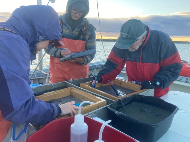
MCMI scientists collect small animals that live on and in the seafloor and describe the type of sediment at each grab sample location. Credit: MCMI.
Reports and NOAA Data Links
Provided below are reports for multibeam echosounder data collection and links to download the data that have been approved by the NOAA Office of Coast Survey. There is generally a two-year waiting cycle for newly collected data to be approved and uploaded by NOAA. To request data collected more recently or in a specific area, please contact the Jesse Minor (jesse.minor@maine.gov).
Interim 2021 Descriptive Report of Seafloor Mapping: Vicinity of Casco Bay (PDF file, 91 pages, 17.8 MB)
Peyton Benson, Maine Coastal Program
September 2021
NOAA Data Link: Data in process of approval. Data may be requested from Jesse Minor (jesse.minor@maine.gov).
During May-August 2021, the Maine Coastal Mapping Initiative (MCMI) conducted hydrographic surveying using a multibeam echosounder (MBES) in marine waters in the vicinity of Casco Bay, off Halfway Rock and Long Island, Maine, respectively. The surveying efforts were conducted to support efforts to enhance coastal resiliency through identification and characterization of seafloor habitat to provide information necessary to managing the marine environment and economy. From April to August 2021, 39.7 mi2 (102.8 km2) of high-resolution multibeam data were collected in the vicinity of Casco Bay off Halfway Rock and within the inshore region off Long Island.
2020 Descriptive Report of Seafloor Mapping: Vicinity of Casco Bay, Mid-coast Maine, Vicinity of Matinicus Island (PDF file, 106 pages, 24.9 MB)
Benjamin Kraun, Maine Coastal Program
May 2021
NOAA Data Link: Data in process of approval. Data may be requested from Jesse Minor (jesse.minor@maine.gov).
During the survey season (April - November) of 2020 the Maine Coastal Mapping Initiative (MCMI) conducted hydrographic surveying using a multibeam echosounder (MBES) in the waters off Casco Bay, mid-coast Maine, and Penobscot Bay, Maine. The surveying was conducted in part to support the Maine Department of Marine Resources' (DMR) efforts to enhance coastal resiliency through identification, characterization, and protection of fisheries critical to the state's marine environment and economy. The surveys also coincide with state and federal efforts to update coastal data sets and increase high resolution bathymetric coverage for Maine's coastal waters. A total of approximately 45 mi2 (117 km2) of high-resolution multibeam data were collected. During the 2020 survey season the MCMI also collected sediment samples, water column data, and video in areas summarized in this report.
2018-2019 Combined Descriptive Report of Seafloor Mapping: Vicinity of Saco Bay to Monhegan Island, Gulf of Maine (PDF file, 81 pages, 10.5 MB)
Benjamin Kraun, Maine Coastal Program
March 2020
NOAA Data Link: Data in process of approval. Data may be requested from Jesse Minor (jesse.minor@maine.gov).
Summary: During the 2018 survey season (July - November) and part of the 2019 field season (April - August), the Maine Coastal Mapping Initiative (MCMI) conducted hydrographic surveying using a multibeam echosounder (MBES) in the waters off southern and mid-coast Maine. The surveying was conducted in part to support the Federal Bureau of Ocean and Energy Management's (BOEM) efforts to enhance coastal resiliency through identification and characterization of potential sand and gravel resources on the outer continental shelf that may be used for beach nourishment. The surveys also coincide with state efforts to update coastal data sets and increase high resolution bathymetric coverage for Maine's coastal waters. A total of approximately 71 mi2 (184 km2) of high-resolution multibeam data were collected in the surveyed areas. An additional 6.5 mi2 were collected in nearshore waters for the purposes of assessing nearshore and riverine sand movement as well as mapping eelgrass beds.
2017 Descriptive Report of Seafloor Mapping: Lower Kennebec River, Bath to Fort Popham (PDF file, 71 pages, 7.0 MB)
Kerby Dobbs, Maine Coastal Program
October 2017
NOAA Data Link: Survey W00451
Summary: During May of 2017 the Maine Coastal Mapping Initiative (MCMI) conducted hydrographic surveying using a multibeam echosounder (MBES) in the estuarine portion of the lower Kennebec River from Bath to Fort Popham in midcoast Maine. Follow-up surveys were conducted on June 2, 2017 in three select areas because they represent zones where sediment is highly mobile and the comparison between surveys on two separate occasions is a valuable tool for estimating sediment transport dynamics in the Kennebec River estuary; especially where the deposition of sediment may impede safe navigation. The surveying was conducted at the request of the Maine Submerged Lands Program to help accomplish a variety of objectives, including but not limited to: identification and delineation of submerged cables in charted cable areas, locate and delineate submerged debris, evaluate sediment transport and potential sand and gravel resources for beach nourishment, provide up to date navigational data for NOAA's Office of the Coast Survey, establish baseline habitat coverage, and to possibly open previously restricted areas to commercial fishing, aquaculture, and overnight recreational boating.
2017 Descriptive Report of Seafloor Mapping: Southport Island to Monhegan Island, Gulf of Maine (PDF file, 33 pages, 23.9 MB)
Kerby Dobbs, Maine Coastal Program
October 2017
NOAA Data Link: Survey W00450
Summary: During the survey season (April-September) of 2017 the Maine Coastal Mapping Initiative (MCMI) conducted hydrographic surveying using a multibeam echosounder (MBES) in the waters off of mid-coast Maine. The surveying was conducted in part to support the Federal Bureau of Ocean and Energy Management's (BOEM) efforts to enhance coastal resiliency through identification and characterization of potential sand and gravel resources on the outer continental shelf that may be used for beach nourishment. The surveys also coincide with state efforts to update coastal data sets and increase high resolution bathymetric coverage for Maine's coastal waters. A total of approximately 125 mi2 (325 km2) of high-resolution multibeam data were collected in the surveyed area. During the 2017 survey season the MCMI also collected sediment samples, water column data, and video in 69 locations.
2016 Descriptive Report of Seafloor Mapping: Federal Navigation Channel of Saco River, Biddeford/Saco to Camp Ellis, Maine (PDF file, 54 pages, 5.6 MB
Kerby Dobbs, Maine Coastal Program
February 2017
NOAA Data Link: Survey W00449
Summary: In May of 2016 the Maine Coastal Mapping Initiative (MCMI) conducted hydrographic surveying within the navigable waters of the Saco River between Camp Ellis and the Biddeford/Saco area located approximately 8 km (5 mi) upstream. Bathymetric (e.g. depth) and backscatter (e.g. seafloor substrate) data were collected using a multibeam echosounder (MBES). Preliminary analyses of these data provided the basis for a more specific investigation using underwater video recordings to help characterize the distribution and nature of submerged debris in the vicinity of a proposed dredging of the federal channel in the Biddeford/Saco portion of the Saco River. The results of the submerged debris investigation may facilitate further assessment of potential hazards posed by submerged debris and/or shallow portions of navigable waters within this portion of Saco River. This project also coincides with state efforts to update coastal data sets and increase high resolution bathymetric coverage for Maine's navigable waters and provides new data in the areas covered by National Oceanic and Atmospheric Administration (NOAA) nautical charts (e.g. coastal and harbor) 13286 and 13287 in southern Maine.
2016 Descriptive Report of Seafloor Mapping: Mid-coast Maine (PDF file, 91 pages, 17.7 MB)
Kerby Dobbs, Maine Coastal Program
January 2017
NOAA Data Link: W00448
Summary: During the survey season (April-October) of 2016 the Maine Coastal Mapping Initiative (MCMI) conducted hydrographic surveying using a multibeam echosounder (MBES) in the waters off of mid-coast Maine. The surveying was conducted in part to support the Federal Bureau of Ocean and Energy Management's (BOEM) efforts to enhance coastal resiliency through identification and characterization of potential sand and gravel resources on the outer continental shelf that may be used for beach nourishment. The surveys also coincide with state efforts to update coastal data sets and increase high resolution bathymetric coverage for Maine's coastal waters. A total of approximately 62 mi2 (161 km2 of high-resolution multibeam data were collected, 57 mi2 (148 km2) in the "mainscheme" area of federal (19 mi2) and state (38 mi2) coastal marine waters, and 5 mi2 (13 km2) in nearshore embayments and estuaries. During the 2016 survey season the MCMI also collected sediment samples, water column data, and video in 54 locations, 43 in state water and 11 in federal waters, all within the mainscheme survey area.
2015 Descriptive Report of Seafloor Mapping: Midcoast Maine (PDF file, 17 pages, 2.3 MB)
Kerby Dobbs, Maine Coastal Program
January 2016
NOAA Data Link: W00289
Summary: During the survey season (May-November) of 2015 the Maine Coastal Mapping Initiative (MCMI) conducted hydrographic surveying using a multibeam echosounder (MBES) in the waters off of mid-coast Maine. The survey was conducted in part to support the federal Bureau of Ocean and Energy Management's (BOEM) efforts to enhance coastal resiliency through identification and characterization of potential sand and gravel resources on the outer continental shelf that may be used for beach renourishment and for state efforts to update coastal data sets and increase high resolution bathymetric coverage for Maine waters. A total of approximately 82.5 mi2 (213.5 km2), 80 mi2 (207 km2) mainscheme and 2.5 mi2 (6.5 km2) inshore, of high-resolution multibeam data were collected by MCMI between May and November 2015. During the 2015 survey season the MCMI also collected sediment samples in 61 locations, 43 in state water and 18 in federal waters, in the approximately 80mi2 (207 km2) mainscheme survey area.
Submerged Glacial Features: Offshore Kennebunkport, Southern Maine (PDF file, 14 pages, 2.0 MB)
Kerby Dobbs, Maine Coastal Program
March 2017
Summary: During the 2014 survey season (April - November) the Maine Coastal Mapping Initiative (MCMI) conducted hydrographic surveys using a Kongsberg EM2040C multibeam echosounder (MBES) in the waters off the coast of southern Maine. The approximately 40 mi2 (104 km2) coverage area was centered approximately 9 miles (14.5 km) east-southeast of Kennebunkport, with depths ranging from 30 to 105 meters (below mean lower low water) (Figure 1). Visualization and experienced interpretation and of seabed features within these high-resolution MBES data (bathymetry and backscatter intensity) and 1st-order derivatives (e.g. bathymetric hillshade) may also provide additional geomorphologic context within the region. Although the majority of the seabed in the 2014 coverage area was exposed bedrock, several areas contained laterally extensive deposits of unconsolidated sediment. A recent review of these data identified seven zones containing features of suspected glacial origin.
2014 Descriptive Report for Seafloor Mapping: Areas off Southern Maine (PDF file, 15 pages, 1.5 MB)
David Armstrong, Maine Coastal Program
March 2015
NOAA Data Link: W00288
Summary: The Maine Coastal Mapping Initiative conducted a multibeam survey using a Kongsberg EM 2040C multibeam in the waters off the coast of southern Maine. Data was acquired from June to October 2014. The survey was conducted as part of a grant from Bureau of Ocean and Energy Management (BOEM), for beach restoration and reconciliation. The bathymetry and backscatter will primarily be used to determine the potential for sandy deposits. The project also coincides withstate efforts to update coastal data sets and bring high resolution bathymetric maps into Maine waters. This grant allowed for the purchase of new multibeam sonar, positioning equipment, and other equipment needed for bathymetric mapping and bottom sampling. In addition to multibeam work the survey also conducted drop camera and bottom sampling to ground truth the data. The project provides new data in the areas covered by NOAA nautical charts 13286 in southern Maine, and 13296 and, 13288 in the Boothbay Harbor/Linekin Bay region of Maine.
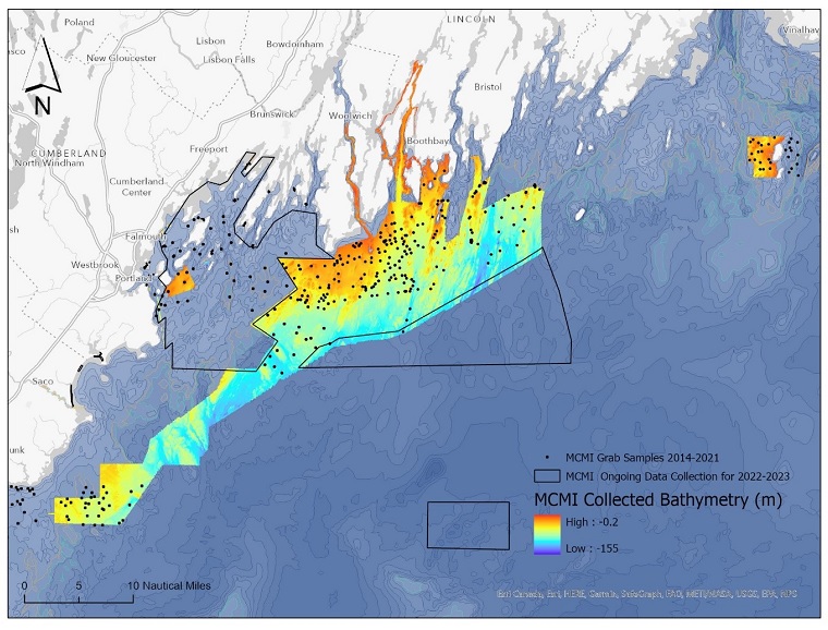
MCMI has collected bathymetry and seafloor hardness data as well as grab samples for sediment and fauna community analysis from offshore Kennebunk to Matinicus, Maine. This map shows the areas of data collection through 2021. Credit: MCMI.