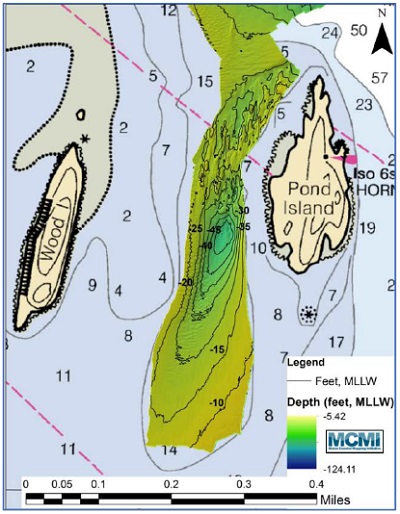
Bathymetry at Pond Island Shoal. Credit: MCMI.
Introduction
The Maine Coastal Mapping Initiative (MCMI) is an effort to improve coastal and marine maps in the region and improve our understanding of marine habitat. Through partnerships with numerous organizations*, we have utilized sonar technology and seafloor sampling to locate shipwrecks, compare eelgrass mapping methods, track sand movement at beaches over time, investigate historical cable corridors to determine current use, and document new invasive species.
The following project highlights provide a few examples of the applications of MCMI. Please let us know if you are interested in collaborating on a new project. Reach out to the Maine Coastal Mapping Initiative Program Lead at DMR, Jesse Minor (jesse.minor@maine.gov).
Links to the project reports are below. PDF files may require free Adobe Acrobat Reader software (download here) to view or print.
Assessing Sediment Budgets in Support of Beach Nourishment and Coastal Community Resiliency
Through this project, the Maine Geological Survey and Maine Coastal Program worked together with Nearview LLC on the collection and analysis of topo-bathymetric elevation coverage from the beach to the nearshore at several Maine beaches adjacent to federal navigation harbors which are regularly dredged. Through this project, we developed and performed methods to assess the elevation change over time following onshore and nearshore sand placement to evaluate the successes of past beach nourishment and nearshore placement projects. We collected topographic-bathymetric elevation over multiple years in the spring and fall at Wells Beach, Camp Ellis and Saco Beaches, Pine Point, Ferry, and Western Beaches using Unmanned Aircraft Systems, single-beam and multi-beam echosounder. The project team compiled and reviewed this multi-season and multi-year data and to develop an analysis methodology for comparison of elevation and volumetric changes. We also collected bathymetry data in the Kennebec River, and Jackknife Ledge and Arundel disposal areas to inform dredging and disposal management, sediment budgets. At each of these sites, we performed grab sampling to characterize benthic fauna to inform dredging, disposal, and nourishment projects (specifically regarding rare or sensitive marine benthic species). These methods, analyses, and reports will form a basis for future management at these sites and are transferrable to other sites for nearshore management activities. This project was funded by the NOAA Office of Coastal Management Project of Special Merit Program.
Assessing Sediment Budgets in Support of Beach Nourishment and Coastal Community Resiliency: Topographic and Bathymetric Beach Change Analyses for Wells, Saco, and Scarborough Study Areas (PDF file, 23 pages, 3.3 MB)
Technical Report
Peter Slovinsky, Maine Geological Survey, December 2020
Bathymetric Change and Sand Dynamics in the Kennebec River and Offshore Popham Beach (PDF file, 58 pages, 15.2 MB)
Technical Report
Stephen M. Dickson, Maine Geological Survey
Benjamin Kraun, Maine Coastal Program
December 2020
Sediment and Benthic Fauna Characterization at Four Maine Beaches and the Jackknife Ledge Dredge Disposal Site, 2016-2020 (PDF file, 28 pages, 1.6 MB)
Technical Report
Claire Enterline, Research Coordinator, Maine Coastal Program
Thomas J. Trott, Benthic Ecologist, Contractor to the Maine Coastal Program
Benjamin Kraun, Project Hydrographer, Contractor to the Maine Coastal Program
December 2020
Marine Mammal and Bird Observation and Mapping
As part our bathymetry surveys, MCMI's team includes a observer who records all whale, seal, porpoise and dolphin sitings, and bird sitings that occur between the bow and starboard side of the survey vessel. We geo-spatially record each observation with information on the species, behavior, and distance from the boat. The observations are then analyzed together with the survey transect lines so that observations can be standardized and mapped (as Observations per Unit Effort). We have created kernel density plots for species that are encountered frequently to identify "hot spots" or locations where species are more frequently encountered and have mapped these occurrences by month and season. These observation data have been provided to the NOAA National Ocean Service for inclusion in the Northeast Avian Compendium. To request the data or maps directly, please contact the Maine Coastal Mapping Initiative Program Lead at DMR, Jesse Minor (jesse.minor@maine.gov).
Comparing Different Technologies for Eelgrass Mapping
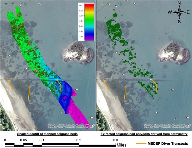
Manipulating the bathymetry layer (left) results in a layer containing only eelgrass returns (right), enabling volume and height calculations. Credit: MCMI.
During July to September 2018, the Maine Coastal Program, Maine Department of Environmental Protection, independent consultant Seth Barker, Nearview LLC, Southern Maine Community College, Maine Geological Survey, and the Casco Bay Estuary Partnership performed a method comparison for mapping and delineating eelgrass beds at representative sites in Casco Bay, Maine. This project enhanced the state's ability to map and assess eelgrass beds by comparing past used methods side-by-side with new technologies. Traditionally, eelgrass beds in Maine have been mapped by taking aerial images, hand digitizing eelgrass bed extent, and ground-truthing a portion of the mapped beds and percent cover using underwater video. In this project, we evaluated data collected by side-scan sonar, multibeam echosounder, Unmanned Aerial System imaging, and single-beam echosounder alongside the traditional aerial image-based method. We compared the data products, data collection feasibility, equipment and operational costs, and time required for each method at a representative sample of eelgrass beds in Casco Bay.
Assessing Various Methods to Map the Health and Extent of Eelgrass Beds (PDF file, 18 pages, 1.9 MB)
Grant Project Report to the Maine Outdoor Heritage Fund
January 2020
Invasive Species in Casco Bay: Discovery, Distribution and Biological Assessment
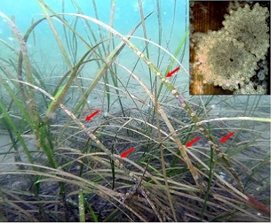
Colonies of Cribrilina (Juxtacribrilina) mutabilis encrusting blades of eelgrass (Zostera marina) at eelgrass bed 1 in Casco Bay, Maine. Red arrows point to representative colonies. Inset shows close-up (20 x) of two colonies on a degenerating blade of Z. marina.
Credit: MCMI.
During July to November 2019, the Maine Coastal Program, Maine Department of Environmental Protection, Wells National Estuarine Research Reserve, and the Casco Bay Estuary Partnership performed invasive species sampling using different methods at representative sites in Casco Bay, Maine to document the spread of two newly discovered invasive species and to understand how different sampling methods may effect invasive species detection. Sampling subtidal areas of the Bay is as important to understanding the number and extent of marine invasive species. Through this project, we 1) determined how wide-spread two non-native species discovered in 2018 were in Casco Bay and the habitat which they colonize, 2) gathered information about marine habitat and species communities throughout the Bay to understand how communities differ based on location, depth, substrate, and other factors, and 3) compared existing invasive species monitoring at docks and piers (constructed habitat) to natural habitat close to these structures to understand the impact of documented invasive species on nearby natural communities.
Invasive Species in Casco Bay: discovery, distribution and biological assessment (PDF file, 10 pages, 1.5 MB)
Grant Project Report to the Maine Outdoor Heritage Fund
December 2020
Shipwreck Investigations
MCMI has conducted two dedicated shipwreck investigations. The first was a large, uncharted wreck discovered while conducting hydrographic surveying in the waters offshore of Pemaquid Point, Maine. Interpretations of high-resolution multibeam sonar data suggest the wreck remains largely intact and rests upright (slightly listing to port) on the seabed at a depth of approximately 90 meters (295 feet). The vessel was approximately 70 meters (230 feet) in length and 10 meters (33 feet) wide, with a stern height of 5 meters (16 feet) and a 10 meter (33 feet) raised bow. During another investigation, MCMI worked with the Maine Bureau of Parks and Lands to explore Pemaquid Harbor for remains of the Angel Gabriel, a vessel lost in 1635 shortly after her arrival from Bristol, England.
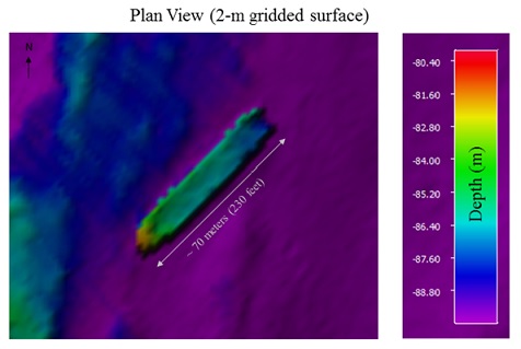
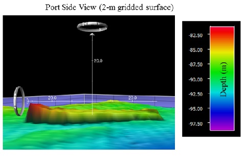
Two views of the Pemaquid Point shipwreck. Credit: MCMI.
Submerged Object Investigation Summary of Colonial Pemaquid: Pemaquid River - John's Bay, New Harbor, Lincoln County, Maine PDF file, 64 pages, 7.0 MB)
Associated Report
Benjamin Kraun, Hydrographer, Contractor to the Maine Coastal Program
December 2018
Investigation of Submerged Debris in the Saco River
MCMI partnered with the Maine Submerged Lands Program and the towns of Biddeford and Saco for this investigation to help locate submerged debris as well as provide up-to-date, high-resolution bathymetry data in the vicinity of a proposed dredging area in the Biddeford/Saco portion of the Saco River.
Preliminary Report of Saco River Submerged Debris Investigation (PDF file, 37 pages, 2.8 MB)
Project Report
Kerby Dobbs, Hydrographer, Contractor to the Maine Coastal Program
June 2016
*Our partners have included: 
- Biodiversity Research Inst.
- Bowdoin College
- Casco Bay Estuary Partnership
- Maine Coastal Program, Dept. of Marine Resources
- Maine Dept. of Environmental Protection
- Maine Dept. of Inland Fisheries and Wildlife
- Maine Dept. of Marine Resources
- Maine Geological Survey, Dept. of Agriculture, Conservation, and Forestry
- Maine Outdoor Heritage Fund, Dept. of Inland Fisheries and Wildlife
- Maine Parks and Lands Bureau, Dept. of Agriculture, Conservation, and Forestry
- The Nature Conservancy
- Nearview LLC
- Southern Maine Community College
- US Bureau of Ocean Energy Management, Dept. of the Interior
- US Office for Coastal Management, NOAA
- US Office of Coast Survey, NOAA
- University of Maine
- Wells National Estuarine Research Reserve