Introduction
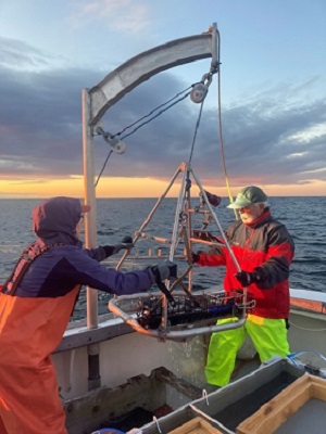
MCMI Scientists retrieve the grab sampling equipment that collects video, water quality information, and a sample containing seafloor sediment and small marine fauna.
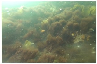
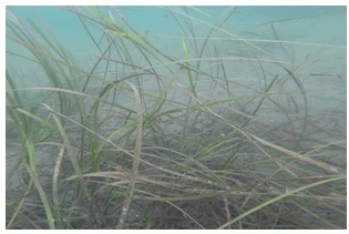
Maine's coastal and marine waters host a large diversity of habitat and species thanks to complex circulation patterns and our location between the Artic and Temperate ecological zones. Maine's marine habitat takes many forms, including mussel reefs, submerged aquatic vegetation, and varied seafloor sediments and morphologies. This diversity of habitats supports a large number of benthic species, which in turn help shape the seafloor structure and communities, are an important component in the marine food chain, and provide valuable ecosystem services. For example, submerged aquatic vegetation like eelgrass beds and kelp forests provide water quality benefits through nutrient uptake, sediment stabilization, and buffering of pH in the adjacent water column while storing carbon, attenuating wave and current energy, and providing habitat for many important fish and other marine species.
Mapping Maine's marine habitats is needed to assess current distribution, habitat availability, and community assemblages. These data are ritical to State and Federal resource agencies for effective protection of unique habitat resources. Through MCMI, our team is helping to describe marine habitats through characterizing habitat types and benthic species assemblages to support research and management efforts. Some of the uses of the data include creating habitat suitability models for important commercial fishes, forecasting the impacts of temperature change, ocean acidification, and nutrient enrichment, and documenting species range expansions and new invasive species.
Our work focuses on using high-resolution bathymetry and bottom hardness information together with video images, sediment descriptions, water quality information, and benthic fauna classifications to better describe our marine habitat and seafloor communities. These efforts have led to:
- Publications documenting first observations of invasive species in coastal Maine
- Reports using species compositions combined with bathymetry and sediment information to model benthic habitat across large areas
- Data available to researchers and managers, such as water column and seafloor water quality, sediment type, and seafloor species presence and abundance
- Descriptions of benthic species assemblages following nearshore sand disposal
Technical Reports and Publications
Links to the reports, with the citation and summaries, are below. PDF files may require free Adobe Acrobat Reader software (download here) to view or print.
Assessment of Benthic Species Assemblages and Their Relation to Environmental Conditions in Casco Bay (PDF file, 16 pages, 1.3 MB)
Thomas J. Trott, Ph.D., Benthic Ecologist, Maine Coastal Mapping Initiative
Technical Report
December 2020
Summary: In partnership with the Maine Department of Environmental Protection (DEP), MCMI conducted benthic species surveys in Casco Bay, Maine during August 2020, as part of the DEP project, Ambient Water Quality Monitoring and Eelgrass Monitoring and Mapping. Analysis of the benthic species found that annelids, molluscs and arthropods were dominant taxa among all stations, however differences among the assemblages were associated with sediment type.
Sediment and Benthic Fauna Characterization at Four Maine Beaches and the Jackknife Ledge Dredge Disposal Site, 2016-2020 (PDF file, 28 pages, 1.6 MB)
Technical Report
Claire Enterline, Research Coordinator, Maine Coastal Mapping Initiative
Thomas J. Trott, Benthic Ecologist, Contractor to the Maine Coastal Mapping Initiative
Benjamin Kraun, Project Hydrographer, Contractor to the Maine Coastal Mapping Initiative
December 2020
Summary: Recent efforts in Maine have identified that understanding sediment transport and the management of beach sediment and nourishment materials is vital to creating better municipal and regional beach management plans, as well as informing dredging and sand disposal. We determined differences among biological communities among nearshore sand enhancement sites, determined sediment grain size based on surface grab samples and backscatter assessment, and assessed differences in grain size and biological community composition at one dredge disposal site pre- and post-disposal and compare these characteristics to a proposed new disposal site. We found that benthic species assemblages were representative of sandy bottom benthos, although there were some differences following sand disposal. We also found that among the beaches sampled, Wells Beach was distinct based on its species assemblage and the presence of a rare species that is sensitive to disturbance. This additional benthic habitat data provides coastal managers a more comprehensive understanding about how nearshore sand placement impacts these areas.
Grandidierella japonica Stephensen, 1938 (Amphipoda: Aoridae) in the Northwest Atlantic Ocean (PDF file from Aquatic Invasions, 15 pages, 4.7 MB)
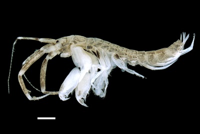
Grandidierella japonica was discovered in 2019 by MCMI scientists. Credit: Thomas Trott, MCP.
Publication: Aquatic Invasions (2020) 15(2): 282-296, https://doi.org/10.3391/ai.2020.15.2.05
Thomas J. Trott, Benthic Ecologist, Contractor to the Maine Coastal Mapping Initiative
Eric A. Lazo-Wasem, Peabody Museum of Natural History, Yale University
Claire Enterline, Research Coordinator, Maine Coastal Mapping Initiative
January 2020
Summary: The aorid amphipod Grandidierella japonica, originally described from northern Japan, is reported for the first time from the Gulf of Maine and Long Island Sound in the Northwest Atlantic Ocean. It was discovered among grab samples of eelgrass (Zostera marina) beds taken in Casco Bay, Maine in summer 2018 and has been found intertidally in Long Island Sound since 2013 along Connecticut shores. It occurs in habitats like its native range but also in rocky areas and tidepools in bedrock. The presence of adults of both sexes, ovigerous females, and immature stages in all collections indicates the species is established. Among males, some morphological characteristics of gnathopod 1 vary with increasing total body length: the number of accessory carpal teeth increases, the carpus shape (length/width ratio) changes, and numbers of stridulating ridges increase. Maine and Connecticut specimens are distinguished from each other by the shape of male gnathopod 1 basis. Morphological variation, temporal differences in discovery, and separation by the biogeographic barrier Cape Cod suggests Maine and Connecticut populations originate from separate introductions.
First record of the encrusting bryozoan Cribrilina (Juxtacribrilina) mutabilis (Ito, Onishi and Dick, 2015) in the Northwest Atlantic Ocean (PDF file from BioInvasions Records, 10 pages, 2.8 MB)
Publication: BioInvasions Records (2019) 8(3):598-607, https://doi.org/10.3391/bir.2019.8.3.16
Thomas J. Trott, Benthic Ecologist, Contractor to the Maine Coastal Mapping Initiative
Claire Enterline, Research Coordinator, Maine Coastal Mapping Initiative
August 2019
Summary: The cribrimorph bryozoan Cribrilina (Juxtacribrilina) mutabilis, originally described from Hokkaido, Japan, is reported for the first time in the Gulf of Maine and the whole of the Northwest Atlantic coast. In September 2018, numerous colonies of C. mutabilis were collected from eelgrass (Zostera marina) beds near Clapboard and Mackworth Islands, and Hog Island Ledge, all located within inner Casco Bay, Maine. Bryozoan colonies encrusted eelgrass, rockweed (Ascophyllum nodosum), and laminarian drift algae. Situated near the discovery location, the city of Portland (Maine, USA) is an active seaport, suggesting introduction through shipping as a likely introduction mechanism. The North Sea is hypothesized to be the most probable area for the source population. Since C. mutabilis appears to have high potential for introduction, it likely occurs on other parts of the Northwest Atlantic coast where it has yet to be identified and recorded.
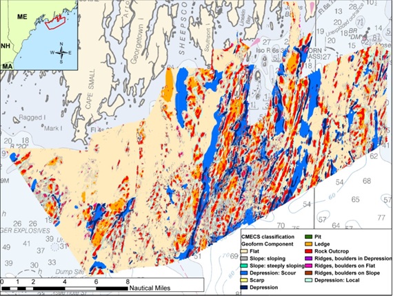
Seafloor features that indicate different habitat types, such as flats, depressions, and ridges, were modeled using high-resolution bathymetry for Midcoast Maine.
Credit: Ivy Ozmon, MCMI.
Maine Coastal Mapping Initiative: 2015-2017 Benthic Infauna Analyses and Habitat Classification - Midcoast Maine (PDF file, 450 pages, 21.4 MB
Technical Report
Ivy Ozmon, Benthic Ecologist, Maine Coastal Mapping Initiative
May 2018
Summary: From 2015 to 2017 multibeam sonar surveys were completed for a 257 mi2 area in Midcoast Maine to create high resolution bathymetric maps and to collect backscatter intensity data for the region. Benthic sampling was conducted to ground truth surficial sediment classifications made from interpretations of the bathymetric and backscatter maps, and these data were used in combination with the hydrographic data to inform benthic habitat classification. One hundred and ninety-four sites were sampled in the surveyed area to classify benthic habitat per the Coastal and Marine Ecological Classification Standard (CMECS). CMECS aquatic setting and geoformation designations were determined using analyses of hydrographic data, water column characterizations were made from analyses of vertical profiles of temperature and salinity, and seafloor substrate and benthic community classifications were generated from analyses of grab samples and seafloor imagery. Relationships between benthic community types and environmental variables were explored using multivariate statistical analysis methods. Predicted distributions of benthic communities were mapped for the surveyed area based on biotic-abiotic associations defined a posteriori, and using an abiotic surrogate, defined by a priori combined substrate-depth classification.
Assessing Various Methods to Map the Health and Extent of Eelgrass Beds (PDF file, 18 pages, 1.9 MB)
Credit: MCMI
Grant Report to the Maine Outdoor Heritage Fund
January 2020
Summary: During July to September 2018, the Maine Coastal Mapping Initiative, Maine Department of Environmental Protection, independent consultant Seth Barker, Nearview LLC, Southern Maine Community College, Maine Geological Survey, and the Casco Bay Estuary Partnership performed a method comparison for mapping and delineating eelgrass beds at representative sites in Casco Bay, Maine. This project enhanced the state's ability to map and assess eelgrass beds by comparing past used methods side-by-side with new technologies. Traditionally, eelgrass beds in Maine have been mapped by taking aerial images, hand digitizing eelgrass bed extent, and ground-truthing a portion of the mapped beds and percent cover using underwater video. In this project, we evaluated data collected by side-scan sonar, multibeam echosounder, Unmanned Aerial System imaging, and single-beam echosounder alongside the traditional aerial image-based method. We compared the data products, data collection feasibility, equipment and operational costs, and time required for each method at a representative sample of eelgrass beds in Casco Bay.
Invasive Species in Casco Bay: discovery, distribution and biological assessment (PDF file, 10 pages, 1.5 MB)
Grant Report to the Maine Outdoor Heritage Fund
December 2020
Summary: During July to November 2019, the Maine Coastal Mapping Initiative, Maine Department of Environmental Protection, Wells National Estuarine Research Reserve, and the Casco Bay Estuary Partnership performed invasive species sampling using different methods at representative sites in Casco Bay, Maine to document the spread of two newly discovered invasive species and to understand how different sampling methods may effect invasive species detection. Sampling subtidal areas of the Bay is as important to understanding the number and extent of marine invasive species. Through this project, we 1) determined how wide-spread two non-native species discovered in 2018 were in Casco Bay and the habitat which they colonize, 2) gathered information about marine habitat and species communities throughout the Bay to understand how communities differ based on location, depth, substrate, and other factors, and 3) compared existing invasive species monitoring at docks and piers (constructed habitat) to natural habitat close to these structures to understand the impact of documented invasive species on nearby natural communities.