Expanded Right Whale Monitoring

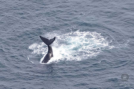
With funding from the Consolidated Appropriations Act, 2023 DMR will significantly expand North Atlantic right whale (NARW) monitoring in the Gulf of Maine (GOM). The GOM, particularly in waters off the coast of Maine, is an under-sampled and under-researched area, resulting in high uncertainty in existing models that determine risk of serious injury and mortality to NARWs by lobster gear. It is this uncertainty that has driven NOAA to make assumptions that have been so problematic for Maine's lobster industry. This program aims to address critical data gaps regarding the presence of NARWs in the GOM with passive acoustic monitoring, boat-based surveys, aerial surveys, and zooplankton monitoring. The expanded monitoring work will give Maine DMR the data we need to appropriately address future federal regulations.

Passive Acoustic Monitoring

PAM Sites

PAM Mooring
Example of an archival  PAM mooring

DMR will conduct archival passive acoustic monitoring (PAM) at 26 sites throughout Maine’s portion of Lobster Management Area 1 (LMA1) and parts of LMA3. 

These will be in addition to eight PAM moorings deployed since 2020 in collaboration with Northeast Fisheries Science Center and the University of Maine.

Pictured is an archival PAM mooring. The 14” hard float provides buoyancy so that once the anchor is released the PAM mooring will float to the surface and DMR can retrieve it. The Apollo Mono beacon sends the latitude and longitude of the PAM mooring via satellite whenever it is at the surface. DMR will use these to track down any PAM moorings, including those that may have been dislodged and come to the surface earlier than expected. The ST600 acoustic recorder is the instrument DMR will use to record ocean sounds at each PAM site. DMR will review these recordings for North Atlantic right whale (NARW) vocalizations, which will indicate whale presence within, on average, a 10-kilometer radius of the PAM site. The VR2AR is an acoustic release and receiver that releases an anchor securing the PAM mooring to the ocean floor so that DMR can retrieve the PAM. The VR2AR release/receiver also detects acoustically tagged fish within a certain distance of the receiver.

In addition to broadscale monitoring with PAM moorings, DMR will investigate a passive acoustic tracking array. The tracking array will consist of five to seven PAM moorings that are centered around the Gulf of Maine Floating Offshore Wind Research Array. This higher density of PAM sites should allow for the location and tracking of vocalizing whales. Data from the tracking array could potentially lead to more detailed information, including estimated number of calling whales within the detection range of the acoustic recorder, vocalization rates, acoustic density estimates, and the depths at which whales vocalize. Four additional archival passive acoustic recorders will be placed in the corners of the grid cell to expand spatial coverage. 

PAM moorings will be swapped out approximately every four months and data downloaded. Once the acoustic recordings have been analyzed by DMR science staff, the NARW acoustic detection data will be uploaded to NOAA Fisheries Northeast Fisheries Science Center’s Passive Acoustic Cetacean Map, a publicly available portal for viewing PAM detections over different periods of time and areas.

If a harvester accidentally entangles a PAM mooring, please contact anita.murray@maine.gov for instructions on returning it to DMR.

Future plans call for near real-time PAM monitoring to support the development of dynamic management in which temporary closures are only established in specific areas if whales are detected.


Visual Surveys

The DMR Division of Marine Mammal Research Survey Program conducts visual surveys for North Atlantic right whales from aerial and vessel platforms throughout the Gulf of Maine. The goal of these survey efforts is to increase our understanding of where and when right whales frequent Maine waters. Since July of 2024, monthly aerial and vessel line-transect surveys have been collecting data to estimate the density and abundance of whales. Survey effort and right whale sightings are uploaded on the day following each survey to Whale Map.

DMR surveys are conducted under NMFS Permit No. 27858

Aerial Surveys 

Vessel Survey Map
Aerial Survey Track Lines with the Maine Lobster Fishing Zones, and LMA1 Restricted Area

DMR has contracted Azura Consulting LLC. to conduct monthly broad scale aerial line-transect surveys along pre-determined track lines that provide dense visual coverage of Maine’s shoreline out to about 60 nautical miles from shore (see Map). Surveys are flown at a ground speed of 100 knots and an altitude of 1000 ft in a high-wing twin engine Partenavia P68 aircraft. The plane is equipped with bubble windows that afford observers a complete view of the ocean on either side of the plane as well as a window that opens for the photography of marine species.

During aerial surveys, two observers are positioned on either side of the plane to record detections of marine species. They use Mysticetus LLC. software to record the effort type (transit, on track, start track, break track, resume track, end track, or off watch), and a GPS is integrated with the program to automatically record date, time, position (latitude and longitude) of the plane, speed over ground, course over ground, and altitude. Observers record environmental variables such as general weather, sighting visibility distance, cloud cover, and sea state on the Beaufort Scale. When marine species are detected, observers record the declination angle of the sighting, which is used to calculate distance from track line to sightings, the species identification, the reliability of that identification (definite, probable or possible), the number of animals and a +/- confidence of that count for groups (example: 20 +/- 5), the direction of travel of the animal or group, and behaviors observed. Data are recorded in accordance with the North Atlantic Right Whale Consortium Database Guidelines.

The plane will deviate from pre-determined track lines to confirm the species identifications of large whales and/or to photograph North Atlantic right whales. Observers attempt to photograph the head of each right whale so that it can be matched to an individual in the New England Aquarium North Atlantic Right Whale Catalog.

DMR Aerial Survey
Observer Natasha Telschow, ME DMR, records data during an aerial survey
North Atlantic Right Whale
North Atlantic right whales (Eubalaena glacialis) photographed by Lenisa Blair (Azura Consulting LLC) on 04 November 2024, NMFS Permit No. 27066

Vessel Surveys

Vessel Survey
Vessel survey area (blue), Maine Lobster Zone Lines, LMA1 Restricted Area

The Survey Program also conducts vessel-based surveys for North Atlantic right whales. These surveys are focused on the area within about 30 nautical miles of the Maine coastline, where the majority of Maine lobster fishing effort is located. Vessel surveys are conducted along predetermined lines inside the blue Vessel Survey Area in the Map.

DMR has contracted the Bar Harbor Whale Watch Company to provide a platform for monthly vessel surveys. Their jet-propelled catamarans M/V Acadia Explorer and M/V Coastal Explorer provide observation platforms that are high enough above the surface to observe whales and stable enough to take accurate range measurements. Bar Harbor Whale Watch Company Captains are experienced in maneuvering near whales, providing opportunities for researchers to photograph individuals while minimizing disturbance to the animals.

During vessel surveys, two observers are positioned on either side of the observation deck with binoculars while one observer records data. Observers record the effort type and sightings data, as detailed, above, for aerial surveys. During vessel surveys the range of the sighting location is recorded using reticle binoculars and the relative bearing to the sighting is also recorded.

Bar Harbor Whale Watch Vessel
DMR vessel survey platform, Bar Harbor Whale Watch Company’s M/V Coastal Explorer, conducting a survey. Photographed by Alison Ogilvie (NEFSC)
Dolphins
Common dolphins (Delphinus delphis) photographed by Natasha Telschow of DMR during a vessel survey in October 2024 under NMFS Permit No. 27066
Fin Whale
A fin whale (Balaenoptera physalus) photographed by Amy Whitt (Azura Consulting LLC) under NMFS Permit No. 27066

Zooplankton Monitoring

Copepods, a type of zooplankton, are a critical food source for NARWs and changes in the distribution of the copepod Calanus finmarchicus have resulted in changes in the distribution of NARWs, most notably in the Bay of Fundy and the Gulf of St. Lawrence.

Given this inherent connection between NARWs and their food, and the potential to forecast this relationship, ME DMR plans to support and expand zooplankton monitoring in the GOM.

This will be achieved by continuing to support the two long-term monitoring stations within the Marine Biodiversity Observing Network that already exist within the GOM, the Coastal Maine Time Series and Wilkinson Basin Time Series stations.

Additionally, two sampling stations targeting Downeast areas in the Eastern Maine Coastal Current and around Jordan Basin will be added to that sampling network, mirroring the protocols and providing habitat context from areas historically used by feeding right whales. New sampling stations will be supported in-house by new DMR staff added to support habitat survey work and through contracts with local fishermen for vessel support.