The South Portland Municipal Boat Ramp, located off Route 77 next to Bug Light, is a popular site. Two cement ramps, a float, an outhouse and a large parking lot can be found here. if launching a boat, be prepared to pay a fee. The area around Bug Light is also a favorite shore fishing site.
Spring Point Ledge Light, also off Route 77 and close to the Southern Maine Technical College campus, provides anglers with plenty of shore access. Spring Point Ledge Light sits at the end of a jetty that extends into the Portland Harbor channel. Parking here is limited.
Located in the center of the city's historic waterfront district is Portland's Public Pier. This site is popular among shore anglers, especially when mackerel are in. Parking at this location is limited.
Another city facility is the Eastern Promenade Boat Launch, located on Cutter Street just off Portland's Eastern Promenade. This facility offers two cement boat ramps, a float, adequate trailer parking, restrooms, a family swimming beach and fishing along the shore line. In addition, an attendant supervises this facility. A fee is charged to use the boat ramps.
The Falmouth Town Landing can be found on Town Landing Road off Route 88. This boat ramp was recently redone, but remains unusable at low tide. A float is on site and there is limited parking. Be prepared to pay a ramp use fee if you are not a town resident.
The Yarmouth Town Landing, which provides access to the Royal River, has a cement boat ramp (a fee is charged for out-of-town residents) and a dock. Parking is plentiful and an outhouse is available. To find this site, take Bayview Drive (on the east side of the river) and follow the access signs to the shore.
This river also supports several busy marinas, one of which, the Yarmouth Boat Yard (located on Route 88), permits the use of their private boat ramp for a fee. Their gravel ramp unusable at low tide) has a float. Parking is adequate and there is an outhouse on site.
Located on the Freeport Road in South Freeport (off Route 1, near the giant Indian) is a sign that will direct you to the town operated Winslow Park. Winslow Park has a paved boat ramp (not usable at low tide) with a float. In addition, this site has adequate parking, restrooms, wooded picnic areas, campsites, nature trails and a swimming beach. A fee is charged to enter the park.
Water Street Landing, located close to the center of downtown Brunswick just off Route 1 on Water Street, provides access to the Androscoggin River below the Brunswick dam. This facility, which opens 1/2 hr before sunrise and closes 1/2 hr after sunset, has a cement boat ramp and a large parking lot. At this location, the Androscoggin River flows into Merrymeeting Bay, which then links with both the upper and lower portions of the Kennebec River.
Sawyer Park, located on the Bath Road in Brunswick just before the boundary with West Bath, provides excellent access to the New Meadows River. This facility offers anglers a cement ramp, float, large parking area, picnic tables and an out-house.
Simpson's Point Landing provides access to Middle Bay for hand-carry watercraft. This site has an older single cement boat ramp located at the head of Middle Bay, which accomodates only carry-in canoes & kayaks. To find this town site, take Route 24 south from Route I in Brunswick, continue south along Main Street to the Mere Point Road, from there to the Simpson Point Road and follow this road until it ends. There is minimal parking, if any, along the roadside.
"Mere Point Boat Launch provides all-tide deep-water access onto Northern Casco Bay. This launch also includes facilities for the launching of kayaks and other hand-carry watercraft, and is located near the southern end of Mere Point Road, approximately 6 miles from the southern end of Maine Street." - Brunswick Parks & Rec
Other sites in the Brunswick region that are closer to open water can be found in South Harpswell and on Bailey Island. One can get to the Harpswell sites from Route I by taking Route 24 south, then Route 123 south. At the end of Route 123 lies the South Harpswell Boat Ramp. This site has a boat ramp, but car and boat trailer parking are not permitted. Privately owned Dolphin Marine Service, located nearby, has a paved boat ramp, dock, ample parking, restrooms and charges a ramp fee.
Following Route 24 all the way south out of Brunswick leads to Great (Sebascodegan), Orrs and Bailey Islands. Turkey Bridge Boat Ramp is on the Prince Point Road just before you leave the mainland and cross over Gurnet Strait to Great Island. This cement boat ramp (not usable at low tide) is town maintained. Parking is in a small dirt lot as well as along the roadside.
Further south on Route 24, a private blacktop boat ramp and float are at the Great Island Boat Yard on Great Island. A fee is charged, parking is limited and a restroom is located here.
Another private boat ramp is located at the S. J. Prince & Son Store on Orrs Island, just before the Bailey Island bridge. The ramp at this site is gravel and can be difficult to use on extreme low tides. Parking here is limited and a ramp use fee is charged at the store.
If you are looking for shore access in this area, check out the end of Bailey Island. This area is sometimes referred to as Lands End and is where Route 24 terminates. Anglers can park in the large lot next to the gift shop.
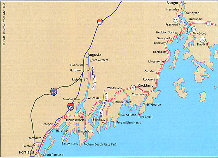
The Kennebec River's tidal waters hold one of Maine's most cherished saltwater sport-fisheries. From Augusta to Phippsburg and Georgetown, the Kennebec's striped bass fishing is currently recognized as being 'World Class."
Edwards Dam in Augusta (removed in the summer of 1999) currently marks the Kennebec River's head-of-tide. Sportfishing in the waters below the dam is popular, with rough shore access provided along the west side of the river. Parking is available in a large gravel lot found in front of the Edward's Power Plant facility, located on Water Street off Route 104. Look for a metal stairway along the edge of the parking lot that leads to the shore.
A short distance down river (along the same Route) is the Augusta Boat Landing. Not only is this a good place to temporarily land your boat, but it is also an easily accessed shore fishing site for striper fishing. This landing is situated next to a large municipal parking lot in the city's old business district. (Note: there is no boat ramp at this location).
On the east side of the river, next to Fort Western, is Augusta's Eastside Boat Landing. This site has a single cement ramp serviced by a float, large parking lot, restrooms, picnic tables and a children's playground. Shore fishing at this site is excellent.
Further down river lies the Butternut Park boat ramp in Chelsea. Follow Route 9 south out of Augusta into Chelsea, turn right onto Ferry Road and continue down the winding road to reach this site. This town operated park has a single gravel boat ramp that is in poor condition and not usable at low tide. On site parking is limited.
HALLOWELL / GARDINER / RANDOLPH
Other boat ramps found further down the west side of the Kennebec fie in the cities of Hallowell and Gardiner. The Hallowell Boat Ramp is on Routes 201 & 27 in the downtown area. it has one cement boat ramp serviced by a float and adequate parking. Shore anglers occasionally fish from the float. The Gardiner Public Town Landing is located just below the Gardiner and Randolph bridge, with access from Route 24. This site has two cement boat ramps serviced by a float. Parking for boat trailers (in a large city lot) is limited. Picnic tables and restroom facilities are available. This site is a popular shore fishing spot, specifically where the Cobbosseecontee Stream flows into the Kennebec River.
Another shore fishing spot in this area is just across the river at the Randolph Town Landing. This site can be found a short distance down the east side of the river from the Gardiner/Randolph bridge, behind a large three story brick building.
Further south on Route 24, on the Kennebec's west side, lies the Richmond Waterfront Park. This park has a single cement boat ramp, a float, limited parking and an outhouse. The Steve Powell Wildlife Management Area on Swans Island is just across the channel and this site serves as its ferrying point.
Continuing south on Route 24, the next public boat ramp is found in the town of Bowdoinham. The Bowdoinham Town Landing is part of a town park, has a paved boat ramp, a dock, ample parking, an out-house and picnic tables. This site provides access to the Cathance River which flows into Merrymeeting Bay. Should you choose to follow the Cathance into Merrymeeting Bay, note that this bay is shallow and can be a challenge to navigate. Merrymeeting Bay eventually drains into the Kennebec River where conditions improve.
The city of Bath has a public dock and two public boat ramps. On Commercial Street in the city's waterfront district is the Bath Public Boat Landing, (there is no boat ramp here) situated between two private marinas. The city's Northend Boat Ramp is located farther up river on Bowery Street, adjacent to a waste treatment plant. This site has two cement boat ramps, a float, an outhouse, plus plenty of parking for both cars and boat trailers. e city's second public boat ramp is found down river just past the historic Bath Iron Works shipyard on Washington Street. The state operated Washington Street Public Launch is new in 1999, has a single cement boat ramp, a float, outhouse and plenty of parking.
Morse Cove Public Launch, one of the busiest boat ramps in the state, is located farther down the Kennebec River in Phippsburg. This state maintained site has a single cement boat ramp, a float and an outhouse. Both upper anct lower parking lots generally offer ample parking. To get to this facile take Route 209 south from Bath, turn left onto Fiddler Reach Road and follow signs.
One of the most productive surf fishing sites found in Maine is along the shoreline of Popham Beach State Park in Phippsburg, near the end of Route 209. An entrance fee is charged at the park gate, but the on-site restrooms, changing rooms, picnic tables, swimming beach and adequate parking can make the fee worth paying. Shore fishing at nearby Fort Popham is also popular. Fort Popham is a few miles beyond the Popham Beach State Park entrance. People can fish from the shoreline as well as off a dock, across from the Fort's entrance. Parking at this site is limited. Outhouse facilities are located next to the parking lot.
Wiscasset Town Landing, off Route I on Water Street in Wiscasset's downtown, offers access to the Sheepscot River. Restrooms, two blacktop boat ramps, plus several docks with attached floats are on site. Fishing from the town dock (not to be confused with the nearby Wiscasset Yacht Club dock) is permitted. Parking is limited, especially spaces for boat trailers.
Another public boat ramp, Wiscasset's Ferry Landing, provides access to the west Back River (off the Sheepscot River). From this site boaters can get to the Sheepscot River and the Sasanoa River. To get to this boat ramp, follow Route 144 off Route 1 until Route 144 bends at a crossroad. Proceed straight through the crossroad and bear left at the 'Y" in road just before you reach the front gate of the Maine Yankee Nuclear Power Plant. Amenities at this site include one blacktop and one cement ramp (both are very steep), a float and a large parking lot (located above the ramp site).
Knickerkane Island Park has a black-top boat ramp that is in good condition. In addition, a swimming float, outhouse, picnic tables and large parking lot are on site. Situated on the east Back River (off the Sheepscot, separating Barters Island from Boothbay), this ramp provides access to the lower Sheepscot River and Sheepscot Bay. To get to the site, follow Route 27 to Boothbay; turn right onto Corey Lane at the Boothbay town common and follow the signs toward Barters Island. The park is on the left just before Barters Island.
Townsend Gut Boat Ramp (redone in 1998) is located on McKown Point Road in the village of West Boothbay Harbor, off Route 27. This town maintained boat ramp is on the right at the base of a hill. This site shares space with a small private landing; there is no public float here and parking for boat trailers is along McKown Point Road only.
A third boat ramp in the Boothbay area is located off Route 96 in the village of East Boothbay. The Murray Hill Boat Ramp, on Murray Hill Road, is paved and provides access to Linekin Bay. This ramp is in good condition, however it is generally not usable one hour before and after low tide and is difficult to use with a strong SW wind. Parking for boat trailers on site is adequate.
The only public boat ramp servicing the Damariscotta River is found at the Damariscotta Town Landing. This site has a single blacktop boat ramp and a float. Parking is in the large town lot where, Specially marked parking spaces are reserved for boat trailers. To get to this location, go to Damariscotta's downtown business district (on Route 1B) and enter the large municipal parking lot that borders the river. The nearby small bridge and surrounding area are also known to offer good shore fishing for targeting stripers.
BRISTOL (NEW HARBOR / ROUND POND)
The historic state owned Fort William Henry in Colonial Pemaquid includes a public boat ramp. The fort is located off Route 130 on Huddle Road in the village of New Harbor. On site are several parking lots and a blacktop/gravel boat ramp. Fishing from the dock behind the restaurant is a popular activity, Particularly when mackerel are running. Paring and ramp use are free and restrooms are near the museum. if you wish to enter the fort's exhibit buildings, there is a fee.
Another public ramp in the Bristol area, off Route 32, is at the village of Round Pond's Town Landing. This site has two blacktop ramps serviced by a float. A fee is charged for ramp use. There is no immediate parking for boat trailers at this site, as space is tight with several busy lobster businesses sharing the location. An outhouse is located nearby. Shore fishing from the Town Dock is popular.
The Waldoboro Marine Park is located along the west side of the Medomak River, off Route 32 on Dutch Neck Road. This town maintained site has a paved boat ramp and adequate parking.
The Waldoboro Town Landing is farther up river in the town of Waldoboro and has a blacktop boat ramp. Parking is in a spacious lot. This facility is on Pine Street, which also runs along the west bank of the Medomak River.
The Thomaston Boat Landing is situated along the east bank of the St. George River on Water Street in Thomaston's waterfront district. This facility, heavily used by both clam harvesters and recreational fishermen, has a cement boat ramp and a float. An adequately sized parking lot can be found at this site.
ST. GEORGE (PORT CLYDE / TENANTS HARBOR)
Where Route 131 ends on the St. George peninsula, lies the Port Clyde Boat Ramp. This site is often crowded, especially when the ferry is in from Monhegan Island. Due to this congestion, parking is limited with no spaces reserved for boat trailers. A single cement boat ramp services the site and outhouses can be found at the ferry dock. Mackerel fishing from the town dock is a popular activity.
Traveling north on Route 131 brings you to the village of Tenants Harbor. Along the shore on Commercial Street lies the Tenants Harbor Town Landing. This facility has a single cement boat ramp serviced by a float. Parking in the small lot is limited to 4 hours with no spaces for boat trailers.
Access to the Weskeag River and its locally known striped bass fishery can be had via the South Thomaston Town Landing. This site, located off Route 73, Has a single blacktop boat ramp and adequate parking. Shore fishing here can be excellent, especially below the Route 73 bridge.
Snow Marine Park, on Mechanic Street (off Route 73) in Rockland's southend, is the busiest boat ramp in the area. Two cement ramps, a float, an outhouse and large parking lot can be found here. Be prepared to pay a fee if you plan to use the ramp.
One of the most visited attractions in this region is the Rockland Breakwater Light. This mile long breakwater, which is constructed of large granite blocks, is used by both sightseers (the light house at the end of the breakwater is the chief draw) and fishermen. The catch of shore anglers fishing off the breakwater consists mostly of mackerel and pollock, with the occasional striped bass, cunner and black sea bass mixed in. To get to this site, take Waldo Avenue off Route I at the north end of town and follow shore access signs until you arrive at the breakwater. Parking here is limited at best.
Rockport Marine Park lies at the foot of Rockport Harbor. The park has one black-top boat ramp, picnic tables, benches, out-houses and several floats. Parking for this facility is adequate with a few places set aside for boat trailers. A fee is charged to use the ramp. Fishing off the Harbor Master's dock is permitted, but fishing off several other docks in the park is not allowed.
In the town of Lincolnville, next to the Maine State Ferry Landing and along Route 1, is the Lincolnville Beach Boat Ramp. This is a town maintained boat ramp. A launching fee is charged for use of the blacktop ramp, there is limited free parking in the town lot and an outhouse is nearby. When the town lot is full, paying to park in the state owned lot is an option.
The Northport Public Landing (no boat ramp here) is a popular shore fishing location, especially when mackerel are running. To get here, take the Shore Road off Route 1 at Northport and follow signs to the landing. Parking here is adequate. Another good shore fishing site is off the Bayside Town Dock in the village of Bayside. Follow the Shore Road north to Bayside Road to arrive at this location. Parking here is limited at best.
The Belfast Town Landing is located in Belfast's waterfront district. An excellent extra-wide blacktop boat ramp, a large pier with floats, picnic tables, restroorns and large parking lot make this site user-friendly. A launching fee is charged to use the ramp and, due to boat traffic, shore fishing is not permitted off the dock. If you need assistance or information about the harbor, check in at the Harbor Master's office next to the ramp.
The Searsport Town Landing offers both shore fishing and a boat ramp. The town pier, float, a blacktop ramp, large parking lot, picnic tables and an outhouse can be found here. To locate the landing, look for a shore access sign on the right as you enter Searsport on Route 1 from the south.
The Searsport Causeway connects Sears Island with the mainland. At this site parking is along a side road and shore fishing for stripers is possible off both sides of the causeway. To get to site, take a right onto Kidder Road when traveling north on Route 1 from Searsport.
Providing access to Stockton Springs Harbor is the Cape Docks Boat Ramp. To get to this site, follow Route 1 north into the town of Stockton Springs; proceed to the center of town and turn right onto Cape Road; follow Cape Road until making a right onto West Cape Road; then turn onto Dock Road and continue to the site. This town maintained facility has a single cement boat ramp that is in good condition. Parking is adequate. This site is mostly used by commercial fishermen and pleasure boat owners whose vessels are moored in the harbor.
The Penobscot River has a history as one of Maine's most noted Atlantic salmon rivers and still supports several Atlantic salmon fishing clubs near its head-of-tide. Please note that fishing for Atlantic salmon in Maine requires an Atlantic salmon fishing stamp. In addition, this is a hook and release fishery and only fly fishing gear can legally be used. This paragraph has been superceded by Atlantic Salmon Commission Regulation which currently prohibits fishing for or taking Atlantic Salmon by any means from all Maine waters.
The Penobscot River is also experiencing growth in its striped bass fishery. Several boat ramps on the lower reaches of the river provide good access to anglers with this species in mind.
Two boat ramps provide access from the west side of the Penobscot River. The northern-most is Turtle Head Marina Boat Ramp off Route 1A in the town of Hampden. This ramp is in good condition and is serviced by a float. Parking is not a problem and restrooms are available. The second boat ramp is at Grist Mill Park, down river along Route 1A in the town of Frankfort. Available here are a paved boat ramp (not usable at low tide) and a large parking lot.
EDDINGTON / BREWER / ORRINGTON / VERONA
Anglers targeting Atlantic salmon may try their luck shore fishing at the Penobscot River's head-of-tide In Eddington. This paragraph has been superceded by Atlantic Salmon Commission Regulation which currently prohibits fishing for or taking Atlantic Salmon by any means from all Maine waters. From Brewer, follow Routes 9 and 178 east; turn left with Route 178 where Route 9 separates; immediately take Monument Drive; follow to the dirt and cobble access road on the left, just before Monument Drive reconnects with Route 178; walk or carefully drive to the shore.
Located farther down river along the east bank are two more boat ramps. just off Routes 9 and 178 in Brewer is the North Main Street Boat Ramp with a large cement ramp (not usable at low tide) and large parking lot.
Still farther down river is the South Orrington Boat Ramp (unusable at low tide) which has adequate parking. In the village of South Orrington, turn onto Blake Road from Route 15, cross Settlers Way Road and continue to the site.
Verona Park boat ramp is at the lower reaches of the Penobscot River on Verona Island. This ramp is in good condition, there is plenty of parking and this site has the added benefit of being a fine shore fishing spot for stripers. To get to the park, take a left off Route I north prior to going over the bridge connecting Verona Island and Bucksport.
The South Penobscot Boat Ramp provides access to the Bagaduce River. To get to this site, follow Route I north out of Bucksport and connect with Route 175 south; just before entering the village of South Penobscot, look for the boat launch on the right. This town maintained cement ramp is in poor condition, is not usable around low tide and has limited parking.
Next to the Fire Station in the center of downtown Blue Hill lies the near Blue Hill Town Landing. This boat ramp provides access to Blue Hill Harbor and Blue Hill Bay. To get to the site, take Route 15 south off Route 1, just north of Bucksport. This site has a single cement boat ramp (unusable at low tide) serviced by a float. Parking for the site is adequate.