Index
- The Importance of Precise Harvest Locations on Tags
- 2021 Emergency Shellfish Closures in Western Maine Due to Oil Spills
- New Phytoplankton Data and PSP Forecast Explorer Website
- Recreational Shellfish Harvest; What to Know Before You Go
- Shellfish Long-term Environmental Monitoring Project
The Importance of Precise Harvest Locations on Tags
By James Becker, Seafood Technology Supervisor
When shellfish are harvested, they must be tagged with important information. One of the key details is the harvest location. This information is used when conducting a shellfish illness traceback so the more precise the better. For example, if somebody became sick from eating oysters, the Maine DMR and ME CDC would conduct a joint illness investigation to figure out where the oysters were grown and harvested. The investigation would start at the establishment where the oysters were eaten, usually a restaurant. Dealer and or harvester tags would be collected from the retailer for up to ten days prior to the onset of illness. This allows DMR to pinpoint which dealer delivered them and to isolate, as precisely as possible, the geographic location of harvest. If the location written on the tags is vague, like "mid-coast Maine", then that entire part of the coast could potentially be closed for a significant amount of time. Whereas, if a more precise location was used, like the name of the cove or a specific aquaculture lease site, only that particular area may be closed. This prevents a much larger than necessary closure, which could impact multiple harvesters and/or aquaculture sites and have a larger economic impact on the shellfish industry.
Providing a narrower resolution for harvest location allows the Maine DMR to visit the area or aquaculture site to see if the problem is due to a high level of a dangerous bacteria or toxins in the water, a pollution event, or poor handling of the shellstock. Whatever the cause of the illness may be, the area or lease can be closed if needed and resolved at the smallest geographic location. Moreover, if a recall of the shellfish is implemented, the smaller or more precise the location, the less product that would be recalled and destroyed.
This key piece of information also needs to be carried from the harvester tag to the dealer tag, keeping that information available along the chain of sale from the aquaculture site or mudflat all the way to the retail end point. The requirement in the most recent version of the National Shellfish Sanitation Program Model Ordinance is:
"The most precise identification of the harvest location as is practicable including the initials of the State of harvest, and the Authority's designation of the growing area by indexing, administrative or geographic designation. If the Authority has not indexed growing areas, then an appropriated geographical or administrative designation must be used (e.g., Long Bay, Decadent County, lease number, bed, or lot number)."
Providing the precise location on the shellfish tag prevents the closure of more area than is necessary, impacts industry much less in the event of closure, and allows for a more efficient and effective process for protecting the public.
2021 Emergency Shellfish Closures in Western Maine Due to Oil Spills
By Kelsey Woodhead, Marine Resources Specialist I
Last year there were several oil spill incidents that closed parts of the coast for shellfish harvest in Western Maine. Oil spills can be caused by many things, but the most common causes in coastal Maine are overfilled or ruptured home heating oil tanks, or sunken vessels. Closures in 2021 included areas in the Weskeag River in South Thomaston, Damariscotta River in Newcastle, Back River in Boothbay, and Middle Bay in Brunswick (Figure 1). When an oil spill occurs, there is the possibility that shellfish in the area around an oil spill will contain potentially harmful chemicals which could pose a risk to human health. The main risk is that some of these chemicals, polycyclic aromatic hydrocarbons, can be carcinogenic and harmful in large amounts. Along with the health risk, it is also unlawful as well as generally unappealing to sell seafood that smells or tastes like oil (NOAA Office of Response and Restoration, 2021).
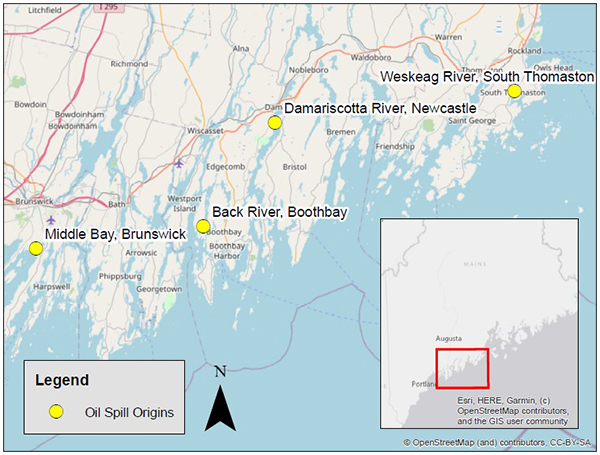
Figure 1. Locations of the four oil spills that occurred in western Maine in 2021. Map by Melissa Cote.
Once a DMR staff member is notified of an oil spill, it is their job to inform the DMR oil spill coordinator, Marine Patrol, and the Bureau of Public Health. Public Health will send out an emergency closure notice and will begin the process of sampling and testing to re-open the site affected by the spill. Sampling does not occur until after the spill has stopped, the area has been cleaned, and there is no longer any detection of the spill. The shellfish samples are comprised of 6-12 shellfish from the area of the spill and an additional 6-12 shellfish from an uncontaminated area as near to the spill as possible. The uncontaminated sample serves as a negative control. Depending on the size of the spill, more than one sample in the affected area may be taken.
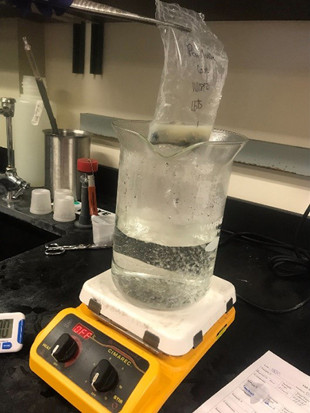
Figure 2. Photo by Amy Webb of shellfish meat boiling process. This is done to capture any potential oil vapors present in the shellfish meat for the organoleptic evaluation.
Once collected, the shellfish are wrapped in aluminum foil in order to preserve the sample and its odors. The samples are marked with the location, time and date of collection and are processed within 24 hours. A qualitative organoleptic evaluation, or "sniff test" is performed on the shell stock, followed by the un-cooked shucked meat, and finally the boiled meat of each of the samples. The negative control is used to compare to the samples from the affected area to evaluate for the presence of taint. Results are recorded and used to determine if the affected area is safe to re-open to harvesting.
Reference:
"Seafood Safety after an Oil Spill." NOAA Office of Response and Restoration, NOAA, https://response.restoration.noaa.gov/oil-and-chemical-spills/oil-spills/resources/seafood-safety-after-oil-spill.html
New Phytoplankton Data and PSP Forecast Explorer Website
By Adrienne Tracy, Marine Resource Specialist II
DMR has partnered with Nick Record's Ecological Modeling Lab at Bigelow Laboratory for Ocean Sciences to create a website that informs the public about the current presence of harmful algal blooms also known as "Red Tide" and forecasts paralytic shellfish poisoning (PSP) toxin levels in shellfish found in the Gulf of Maine.
DMR's Bureau of Public Health collects water and shellfish samples along the coast of Maine to monitor for the presence of harmful algal blooms that produce toxins in the Gulf of Maine. These algae (or phytoplankton) can cause illnesses in humans such as PSP. Biotoxins in the Gulf of Maine are produced by certain phytoplankton genera such as Alexandrium, Pseudo-nitzschia, and Dinophysis. As shellfish filter feed on these phytoplankton they can accumulate toxins in their bodies. If a human eats toxic shellfish, it can cause them to get sick. In response, DMR closes areas for shellfish harvesting where PSP toxins are present in shellfish to protect people from getting sick. While some algal blooms have historically happened during predictable times of the year, until now there has not been a way for the public to know the current bloom conditions in the Gulf of Maine.
Over the last year, DMR created a test website to display the PSP forecasting information along with DMR's phytoplankton monitoring data. This website is now open to the public. There you will find general information about biotoxins, interactive maps for the PSP forecast and DMR Phytoplankton data, and DMR's archived phytoplankton data from 2015-2021. In addition, there are graphs and interactive maps that show how the blooms of each harmful phytoplankton genus has progressed over the season.
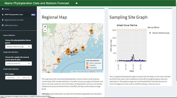
The PSP forecast developed by Bigelow uses DMR's shellfish toxicity data and other environmental data on a weekly basis to predict how likely an area is to have closure-level amounts of PSP toxins present in shellfish the next week. The goal of this forecast is to allow harvesters and growers to make more meaningful decisions about what to do in the weeks leading up to possible shellfish closures and re-openings. Please note this forecast is still in the testing phase and is not the criteria used by DMR to make shellfish closures.
Recreational Shellfish Harvest; What to Know Before You Go
By Erick Schaefer, Public Health Bureau Scientist
Congratulations! You are coming to the coast of Maine this summer and are going to get to relax and enjoy a vacation with the family. Or perhaps you are a local who is interested in harvesting your own food. Maine is famous not only for lobsters, blueberries, and potatoes but also shellfish like clams and mussels. These shellfish are good for eating, and harvesting your own is a fun activity.
Now don't worry if getting bit by greenhead flies, no see um's, and mosquitos, while getting stuck in the mud doesn't sound like your cup of tea. There are numerous licensed retailers of shellfish located throughout the entire state. Not only do they provide wild harvested shellfish, but many also sell farmed aquaculture products like oysters. As long as you purchase your shellfish from a licensed retail location, you can rest assured that you are buying a safe product.
If you choose to harvest your own shellfish, there are a few things you need to know before you go.
- Do I need a license?
- Is the area I wish to harvest from open?
- What species can I harvest, what size and how much?
DMR has a website that will provide most of the answers you need. Let's take these questions one at a time.
- Do I need a license? The short answer is no, you do not need a state license. However, Maine allows coastal towns the option to co-manage their shellfish resource so you may need a town license to recreationally harvest. Now you may be wondering how I am supposed to know which towns have a Municipal Shellfish Program? You can open the following link Towns with Shellfish Programs and see the current list of towns with Municipal Shellfish Programs. This webpage will also show you town closure information. As an example, open the link and look at Addison. Go over four columns to the one labeled "Conservation Closure Map". Conservation closures are put in place by the town to help protect or preserve resource.
Now you know the town you wish to harvest in has a shellfish ordinance, call the town office and ask what you need for recreationally harvesting shellfish. If the town you are interested in is not listed on the webpage, then proceed to question #2 and don't worry about needing a town license.
- Is the area I wish to harvest from open? The most common question we receive here at DMR is whether or not area "XXXX" is open for shellfish harvest. Of course, you are still welcome to call DMR, but we have some tools on our website that will help you figure out closures on your own. Open the following link to access a mapping interface that shows all of our current closures: Shellfish Closure Map. When this first opens you will be asked to read a short paragraph and check a box agreeing to the terms and conditions. Once you have done that, you can enter the name of the town in the search box at the top or use the zoom and pan function to navigate to the area you are interested in. Then you can click on the "legend" tab which is located on the top right of the bar of the map. This will explain what the map is showing you. If you don't want to use the legend just hover over the area of interest and left-click. This will open a description of the area. As an alternative, open the following link: Maine Growing Area Closures: Shellfish Area Inventory with Legal Notices and Maps to get the legal description of the closure boundaries or a static map. As you scroll down the page, you will see a header named "Statewide Closures", this will list all our current closures and the date they went into place. An example of a statewide closures is an emergency closures for a flood event or heavy rainfall. Scroll down a little further and you will see the statewide inventory of all our closures listed by Growing Area. This is where you will find the legal description of the closure boundaries. You can read the Growing Area Description column to locate your area of interest. Once you know where you want to look you can then open the "Bacterial Notice" which gives the legal description of the closures in that area. The same can be done for "Biotoxin" by clicking the appropriate link to the right.
Armed with this information you now need to know what and how much you can harvest recreationally.
- What can I harvest, what size and how much? There is a handy guide at the following link: Shellfish and Snail Identification and Recreational Information. This table provides you with the last piece of the puzzle to safely harvest Maine's shellfish resource recreationally. The table shows a picture of the species, indicates if there is a minimum size limit, what the total catch limit is and any other information that might be important.
We hope you find this information useful and if you have any questions pick up the phone and call or email DMRPublicHealthDiv@maine.gov.
Shellfish Long-term Environmental Monitoring Project
By Denis Nault, Shellfish Program Supervisor
In the Spring of 2021, DMR's Shellfish Management Program started an environmental monitoring project at select sites across the coast of Maine to monitor several physical parameters potentially impacting our vital clam flats. The project will conduct long-term monitoring of clam recruitment, green crab presence, macro algae and other marine organism data at the sites. Water chemistry, salinity, dissolved oxygen, conductivity and pH are also being monitored.
Soft-shell clam recruitment requires several marine and environmental factors for a successful spawning and settlement event. The hope is to put together this data to better evaluate and monitor soft-shell clam recruitment, predators, and the other potential environmental factors to better understand short-term and long-term trends. These data will hopefully assist the municipalities to better manage their valuable wild clam resources.
The Shellfish Program biologists are reviewing the preliminary data from 2021 and will be making some adjustments to the protocols and locations for 2022. One area of growth related to this study will be sediment pH and figuring out exactly what we need to be concerned with and what normal back-ground data look like. The goal is to establish similar sites that can be run by the town shellfish program with the assistance of the DMR Area Biologists.
The three towns in which DMR established the long-term environmental monitoring sites are Machiasport, Deer Isle/Stonington and Phippsburg. Each town has two sites and were chosen for their geographic locations along with their present and historical shellfish resources.