Index
- DMR Mussel Survey Efforts - 2017 Update
- Enhanced Retail Seafood Certificate Information
- Aquaculture & Public Health Web Map
- Water Testing for Growing Area Management
DMR Mussel Survey Efforts - 2017 Update, By DMR Scientist Hannah Annis
In 2016 the DMR began a project that would evaluate the application of using unmanned aerial vehicles (UAV or drones) to map and survey a small area for intertidal mussel resources. The Department's previous survey method of coast wide aerial photography is no longer a cost effective option and has technological disadvantages. Additionally, UAVs also have the capacity to fly at altitudes much lower than the 2,500 feet flown during the plane based aerial surveys.
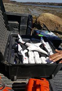
UAV used in DMR mussel survey.
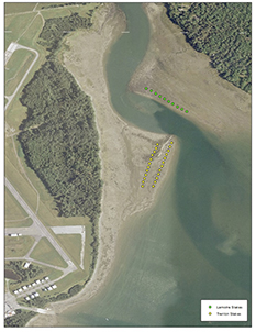
2017 DMR mussel survey plot points.
The location chosen for the trial UAV project is sited at the mouth of the Jordan River, spanning the towns of Lamoine and Trenton. The Jordan River is a significant resource area utilized by numerous harvesters from multiple fisheries. The site also happens to be located next to the Bar Harbor Airport; this resulted in licensing problems that prevented the 2016 UAV from getting off the ground.
In December of 2016, communication between DMR and UAV contractor, Alex Loer of Ocean Works Group, were initiated. By January of 2017, FAA authorization to fly the site was permitted with minor limitations.
Shellfish Management Staff then began the task of preparing the site for both the UAV survey and the "ground truth" survey; both developed and expanded upon from the 2016 survey design. Transect lines were determined and then 34 sample plots were staked 100 feet apart, covering approximately 3400 feet.
In addition, and prior to the UAV survey, DMR worked in partnership with College of the Atlantic to collect samples for evaluating size distribution, abundance, live to dead ratio and length and weight relationship. The length and weight relationship (not previously available for mussels) will provide information that, when combined with size distribution, can be used to estimate the standing crop or bushels (of mussels) per acre.
College of the Atlantic processed the samples and also provided a report based upon the date from the sampling effort. The results concluded that: Overall, the mussels from Jordan River were relatively small, falling primarily within the 35-39 mm and 40-44 mm size classes. Only a limited number of mussels were above the approximate harvestable size of 50 mm (approximately 2 in; for mussel harvesting, there can be no more than 106 mussels per two-quart container, which would average to 2 in per mussel). In addition, these mussels were distributed unevenly throughout the beds with large areas of mudflat containing no mussels.?
On May 4 the first UAV survey was successfully completed. Reviews of the preliminary results have been used to adjust the parameters of the second UAV survey that was scheduled for the beginning of June. The goal of the second flight was to complete to collection of aerial data that can then be used in an overview of the habitat, current state of resource, percent coverage and GIS mapping.
These surveys will provide DMR with updated scientific information that is helpful in making informed management decisions as well as evaluating this new technology's role and future in assessing the state's mussel resources.
Enhanced Retail Seafood Certificate Information
Enhanced retail certificates are for establishments wishing to buy molluscan or bivalve shellfish (clams, mussels and oysters) directly from harvesters. Establishments that buy from other certified dealers instead of harvesters do not need an enhanced retail license, just a retail license.
If you do buy directly from harvesters, the first step will be to apply for the enhanced retail certificate (/dmr/fisheries/commercial/licenses ), and request an inspection of the facility from the Department of Marine Resources (DMR).
Because an enhanced retail certificate allows you to be the primary buyer, you must follow standard reporting procedures required by the DMR Landings Program. Every month, regardless of activity, you will be required to report your purchases.
An enhanced retail certificate authorizes activities at only one establishment or location. If you own multiple locations, you will need an enhanced retail certificate for each one, and separate reporting must be done for each location. You will also be required to have a passing facility inspection annually.
If you have questions in regards to whether or not the Enhanced Retail Seafood Certificate is what you may need, please do not hesitate to call one of the inspectors for more information prior to application. Contact information can be found below:
John Fendl, Seafood Technology Supervisor
207-592-8934
Melinda Cook, Shellfish Dealer Inspector
207-557-3558
Arthur Rowe, Shellfish Dealer Inspector
207-557-3557
Angel Wilson, Shellfish Program Coordinator
207-633-9515
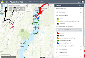
Aquaculture & Public Health Web Map Now Available
There is a new tool available on the Maine DMR website for viewing aquaculture and water quality information. The map is available at /dmr/aquaculture/maine-aquaculture-leases-and-lpas/aquaculture-lease-decisions or by following the "Aquaculture map and recent lease decisions" link under the "Aquaculture" tab on the DMR website. The map displays several layers pertinent to aquaculture and water quality.
- Aquaculture lease and LPA licenses.
- LPA health zones.
- Year end water quality station P90 scores.
- Current bacterial closure information (National Shellfish Sanitation Program classifications).
- Eelgrass beds, seabird habitat, and conserved land.
- Nautical chart and low tide imagery.
Individual layers can be turned on and off by opening the layer menu in the upper right corner of the screen (looks like a stack of tiles). In the image below, aquaculture sites in the upper Damariscotta River are visible, along with NSSP classification and water quality station P90s. Information on a feature can be displayed by clicking on the feature. For example, clicking on a water quality station (the colored circles) will display the station name and its P90 score. The web map contains several other useful features which are more thoroughly documented in the Application instructions linked directly above the map. Questions or comments can be directed to flora.drury@maine.gov. We encourage feedback as this is a new tool designed to aid the public in accessing important information. This map only displays bacterial closures and not biotoxin closures. While every effort is made to keep the bacterial closure layer up to date, the most accurate source for closure information remains the posted legal notices. These are available at the following sources:
Bacterial closures:
www.maine.gov/dmr/fisheries/shellfish/closures
Biotoxin closures:
www.maine.gov/dmr/fisheries/shellfish/closures
Water Testing for Growing Area Management - By DMR Microbiologist Michael Risoldi
In the winter 2017 edition of this newsletter, DMR Scientist Erick Schaefer explained the criteria which are used to determine the various types of shellfish growing area classifications. One of these criteria is bacterial concentration levels, a parameter designed to monitor the water quality in the various growing areas. So let's take a brief look at how DMR's laboratories in Boothbay Harbor and Lamoine determine these bacterial concentrations that are vital to growing area management.
Environmental waters normally contain significant numbers of naturally-occurring bacteria. For public health purposes, growing area managers are concerned with the presence of fecal coliform bacteria, a specific group of bacteria that are associated with the digestive tracts of warm-blooded animals, including humans. The presence of fecal coliform bacteria in water indicates the contamination of that water by animal waste. At each DMR laboratory, analysis is performed to determine a quantitative measure of what is referred to as an indicator bacteria - a species of bacteria that is relatively easy for the lab to identify and quantify and is normally associated with fecal contamination though, in and of itself, may not necessary be detrimental to human health. Presence of the indicator bacteria signals the probable presence of other harmful bacteria and viruses commonly associated with human and animal waste. Escherichia coli (E. coli) is a commonly-used indicator bacteria for fecal contamination in both salt and fresh water and is the one used in analyzing seawaters in Maine.
Laboratory analysis for E. coli at DMR's laboratories involves filtering water samples using sterile technique through filter papers that are capable of capturing any bacteria present in the water. The filter papers are then aseptically transferred to culture plates that contain a specialized growth media that specifically facilitates the growth of E. coli while inhibiting the growth of all other fecal coliform bacteria. The culture plates are incubated under exacting temperature conditions for 24 hours. After incubation, the plates are examined and colonies of E. coli, which are visually evident on the filter papers, are counted. The counts are then converted to a numerical value of the number of viable bacterial colonies - colony forming units (CFU) - in 100 milliliters of the water sample. These CFU values are used, in part, to classify and monitor the water quality of the growing areas.
In 2016, DMR's laboratories analyzed over 11,000 seawater samples for E. coli concentrations. All of these analyses were performed to help ensure the safety of the shellfish product for public consumption and thus help fulfill DMR's Bureau of Public Health mission.