DACF Home → Bureaus & Programs→ Bureau of Parks and Lands → Camping → Backcountry Camping
Backcountry & River Camping
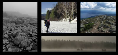
Photo Credits: Staff photos
Scenic campsites in remote settings await those who venture off the beaten path on
Maine's Parks and Public Lands. From wild coastal islands to the mountains and remote lake shores of interior Maine, we have campsites for you.
Remember: Be prepared for changeable weather and variable terrain. Plan outings wisely, don't exceed your ability or that of anyone in your group, and research where you are going. Plan ahead and prepare.
What to Expect
- Remote campsites are almost exclusively first-come, first-serve; reservations are not generally possible.
- Sites most often have a rustic picnic table, access to a pit toilet, and fire ring. Sites on the Maine Island Trail typically do not have these features.
- Backcountry campsites are predominantly accessed by boat (often canoe or kayak) or foot.
- Untreated firewood from outside of Maine has been banned. Please Buy It Where You Burn It!
- Off-season and Winter Camping information.
- Winter Camping Flyer (PDF).
Where to Go
Want to leave the car or truck behind and explore the wild backcountry? Here are some suggestions:
Paddling/Boating +
- Allagash Wilderness Waterway - Established by the Maine State Legislature in 1966 and designated by the U.S. Department of the Interior in 1970 as the first state-administered component of the National Wild and Scenic River System, the 92-mile Allagash Wilderness Waterway in northern Maine is one of America's preeminent canoe trips. View campsites on Google Earth. Note - To launch this link you need to install Google Earth on your computer. River Camping Fees.
- Penobscot River Corridor - Located in the heart of Maine's undeveloped forest land and including 67 miles of river and 70 miles of lake frontage, the Penobscot River Corridor (PRC) provides outstanding opportunities for remote canoe trips, fishing excursions, and whitewater rafting (provided by commercial operators). Portions of the Corridor provide vehicle access to campsites and the river. River Camping Fees.
- Moose River Bow Trip (Holeb Public Lands) - The 34-mile circuit encompassing Attean and Holeb Ponds, as well as the Moose River, is a classic northwoods paddling destination in the headwaters of Moosehead Lake and the Kennebec River. Wildlife and mountain views are common sights along this remote paddling route. Paddling route description and campsite map on Maine Trail Finder.
- Northern Forest Canoe Trail - Fully half of the Northern Forest Canoe Trail from Old Forge, NY to Fort Kent, ME is in Maine. Richardson Lake Public Lands, the Bigelow Preserve, Moosehead Lake Shoreline Public Lands, the Penobscot River Corridor, and the Allagash Wilderness Waterway are all Bureau of Parks and Public Lands properties along this ancient canoe route.
- Maine Island Trail - America's first water trail, the Maine Island Trail is a water trail spanning wild islands and coastal sites along entire Maine coast. Of the nearly 200 islands along the trail, over 40 are owned by the Maine Bureau of Parks and Lands. The trail is managed by the Maine Island Trail Association.
- St. Croix International Waterway - Managed by the St. Croix International Waterway Commission, the St. Croix is a storied paddling destination along the Maine-New Brunswick border.
- Machias River Corridor - The 76-mile canoe trip (with Class I-III whitewater, appropriate for experienced paddlers) begins at Fifth Machias Lake and reaches tidewater in Machias. More than 60,000 acres in the Machias River watershed are conserved, with the Maine Bureau of Parks and Lands owning 14,000-acres centered on First, Second, and Third Machias Lakes.
Close -
Backpacking/Remote Hiking +
- Deboullie Public Lands - The 21,871-acre Deboullie Public Lands offer remote campsites on crystal-clear trout ponds surrounded by low rugged mountains in a sea of forestland in north-central Aroostook County. Over 22 miles of hiking trails await exploration as well as several water-accessed campsites. Guide & Map (24x18-inches PDF 7MB). Call (207) 435-7963, the Northern Public Lands Office, to have a copy of the Guide & Map mailed to you.
- Nahmakanta Public Lands - An extensive network of hiking trails lead visitors along lake shores, up to open ledges, and through deep forests in this 43,000-acre public land. The Appalachian Trail courses through Nahmakanta and interconnects with miles of hiking trails maintained by Maine Parks and Public Lands. Six pristine water-accessible campsites on Nahmakanta Lake as well as several hike-to campsites are available to paddlers and hikers. Guide & Map (24x18-inches PDF 3MB). Call (207) 941-4412, the Eastern Public Lands Office, to have a copy of the Guide & Map mailed to you.
- Bigelow Preserve - The Bigelow Preserve encompasses the entire seven-summit Bigelow Range - including 4,150 feet West Peak, one of only 10 Maine summits over 4,000 feet in elevation. The Appalachian Trail and associated side trails enable several backpacking options on this remarkable public land. Guide & Map (24x18-inches PDF 2MB). Call (207) 778-8231, the Western Public Lands Office, to have a copy of the Guide & Map mailed to you.
- Mahoosuc Public Lands & Grafton Notch State Park - Some of the most challenging terrain along the Appalachian Trail as well as the 38 mile Grafton Loop Trail provide a memorable mountain setting for backpacking in western Maine. Guide & Map (24x18-inches PDF 1.5MB). Call (207) 824-2912, Grafton Notch State Park, or (207) 778-8231, the Western Lands Office, to have a brochure mailed to you.
- Cutler Coast Public Lands - Primitive campsites perched atop dramatic coastal cliffs in an unspoiled stretch of Atlantic coast are reached via miles of rugged hiking through a boreal forest and along an undeveloped coastline. Guide & Map (16x9-inches PDF 1.25MB). Call (207) 941-4412, the Eastern Public Lands Office, to have a copy of the Guide & Map mailed to you.
- Appalachian Trail - 281 miles of the Appalachian National Scenic Trail (AT) are in Maine. Mahoosuc, Four Ponds, the Bigelow Preserve, and Nahmakanta are prominent Public Lands crossed by the AT.
Close -
Looking for a remote camping experience with the convenience of easy access to your vehicle?
Many public Lands provide car-camping sites in remote settings. These primitive camping sites are reached by traveling over gravel logging roads and generally share the same characteristics of the sites described above. Search for camping in Public Reserved Lands.