Home → Bureaus & Programs → Bureau of Parks and Lands → Find Parks & Lands → Park Details
 Land and Water Conservation Fund
 Maine Birding Trail
 Maine Trail Finder
![]() - download brochure (510 KB)
- download brochure (510 KB)
Description
Please check for access and COVID-19 updates by using this link to the Bureau's Safety page.
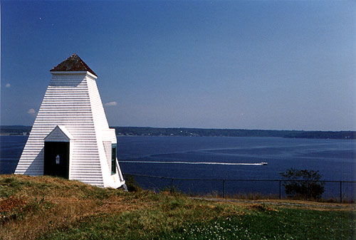
Location Lat 44.466197 / Lon -68.831381 Off U.S. Route 1 in Stockton Springs, on the tip of the peninsula jutting into scenic Penobscot Bay.
Hours / Season Open 9:00 a.m. to sunset daily from May 15 to October 15 unless otherwise posted at the gate. Fee Charged. Visitors may continue to enjoy the park during the off season by parking outside the gate and walking in during these same hours. Please be aware that facilities are closed during the off season.
Picnic tables with a waterfront view, pier and floats for fishing and boating, and access to a scenic bicycling trip are some of the top reasons to visit Fort Point State Park. Located about three miles off U.S. Route 1 in Stockton Springs, and named for the point of which Gov. Thomas Pownall established Fort Pownall in 1759, Fort Point State Park occupies a long peninsula with panoramic views of the Penobscot River and Penobscot Bay. On its 120 acres, the park features more than a mile of rocky shore, a tidal sandbar, and diverse habitat for a variety of plants and animals. Opened in 1974, the park also includes Fort Point State Historic Site and the Fort Point Light Station.
The remains of Fort Pownall contain interpretive panels and a stone marking the original burial site of Gen. Samuel Waldo for whom Waldo County and Waldoboro are named.
Just a short walk from the parking lot, visitors can relax at riverside picnic sites and fuel up for hiking, sightseeing, bicycling, fishing, or paddling. Gentle trails lead hikers through field and forest to rocky shores and historic sites. Interpretive signs describe Fort Point's history as a military, maritime, and tourist center. Using the roads, bicyclists leave the parking lot to ride to the lighthouse or to begin the seven-mile loop around Cape Jellison. Winter visitors go cross-country skiing on the park's hiking trails and closed roads.
If you are interested in learning about geology around the state, check out the Maine Geological Survey Searchable Database.
Download the Fort Point State State Park (PDF)
The Land and Water Conservation Fund contributed to this State Park.Learn more about LWCF.
Activities
- Birdwatching
- Fishing
- Lighthouse
Rules
Consider lending a hand. Contact us if you would like to help with stewardship or maintenance work.
Trails
Visit Fort Point State Park map on Maine Trail Finder.
Services and Facilities
- Picnic area
- See Visitor Accessibility