Home → Bureaus & Programs → Bureau of Parks and Lands → Find Parks & Lands → Park Details
 Land and Water Conservation Fund
 Maine Trail Finder
Description
Please check for access and COVID-19 updates by using this link.
Open 9:00 a.m. to sunset daily from Memorial Day to Labor Day unless otherwise posted at the gate. Fee Charged. - cash or check only, no credit cards accepted. Visitors may continue to enjoy the park during the off season by parking outside the gate, without blocking it, and walking in during these same hours. Please place the admission fee in the self-service collection canister. Please be aware that facilities are closed during the off season.
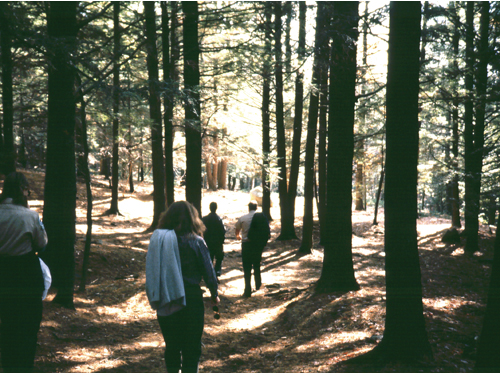
Vaughan Woods Memorial State Park is a 165-acre forested tract along the scenic Salmon Falls River. The park includes picnic facilities and hiking trails through old-growth stands of pine and hemlock. Hiking is available on several trails that connect to make up one large loop, a system of 3+ miles. Visitors can walk shorter looping sections if they choose.
Read the November 11, 2017 Rubys on the Road review of the park.
The Land and Water Conservation Fund contributed to this State Park. Learn more about LWCF.
History
What's in a Name'
Place names tell the story of this area. For example, as you approach the park on Oldfields Road, you will enter an area known as "oldfields" since colonial times. Here, Native Amerians used fire to manage wildlife habitat and to clear land for corn, beans, and squash. When the soil lost its fertility in 8-10 years, they cleared another area for farming and let this land grow up to berry bushes, brush, and finally trees, thus maintaining good farming, berrying, and hunting areas all close by.
About 1785, Jonathan Hamilton, a merchant, built the Hamilton House on a site with a beautiful view of the river and the surrounding countryside. In the early 1800s, this view was a patchwork of small fields of hay, pasture, and row crops. Only 3% of the land that became Vaughan Woods was forested then. However, by 1898, when Emily Tyson, a wealthy Bostonian, bought the Hamilton House and property, there was no open farmland left, just brushland, young white pines growing from old pastures, and a small pine-hemlock-hardwood forest. With great respect for nature, Mrs. Tyson and her daughter, Elizabeth Vaughan,managed the forest for its health and beauty. They also restored the house, which is now open to the public seasonally and owned and managed by Historic New England. In 1949, Elizabeth Vaughan bequeathed to the State of Maine her beautiful forest to be kept "in the natural wild state as the Vaughan Woods Memorial."
Elizabeth Vaughan was a nature lover and an accomplshed horsewoman, who enjoyed daily rides and walks through this forest. Now, we invite you to enjoy it, too.
For more history, read:
"From Field to Forest: The Landscape History of Vaughan Woods Memorial State Park, 1631-1983" by Gary W. Fogg, 1985.
If you are interested in learning about geology around the state, check out the Maine Geological Survey Searchable Database.
Activities
- Hiking (trails)
- Horseback riding
- Picnicking
- Watchable wildlife
Rules
- Picnic on a carry-in, carry-out basis, and take refuse home to recycle.
- Use no alcohol in the park.
- Build fires only in grills provided and use only charcoal.
- Keep pets on four-foot leashes at all times and clean up after them.
- Stay on trails to protect the land.
- Do not pick or remove anything.
- Use wheeled vehicles on the park road and parking lot only.
- Do not feed or disturb park animals.
- There is no camping in this day-use park.
- See Rules for State Parks and Historic Sites
Consider lending a hand. Contact us if you would like to help with stewardship or maintenance work.
Trails
Visit Maine Trail Finder for more information.
On the Trails - The trails through this forest cover some surprising terrain:
The Bridle Path (.7 mile) - Lies on gently rolling high ground, as does the
Bridle Path Loop (.3 mile). Then, the land drops more than 150 feet to the river, where streams continue to deepen their valleys.
Scenic River Run (.8 mile) goes up the banks and down these stream valleys, especially near Trail's End.
Warren Way - Named for James Warren, whose homestead and house once marked this land. From this trail follow the Bridle Path southward to see the plaque marking the Warren home site.
Tours and Programs
Year-at-a-Glance Event Calendar