DACF Home → Bureaus & Programs → Bureau of Parks and Lands → Sebago Lake Shoreline
Sebago Lake Shoreline Restoration Project
What's happening to our beach?
Over time, waves have carried beach sand away. To rebuild and protect the beach, we are using tree trunks, roots, and branches to capture and hold sand in place—a first-of-its-kind lake project in Maine! This is a temporary look for our long-term beach enjoyment.
Protecting the shoreline protects Sebago Lake as a drinking water source, a home to loons and landlocked salmon, and a place we can all enjoy.
Images of the restoration as it progresses

Natural materials at Sebago Lake State Park are being scientifically engineered into structures designed to capture and hold the sand brought in by wave action in order to rebuild and protect the beach.
We are using the physics of a natural process called aggradation. Aggradation occurs when land elevation increases due to the depost of sediment, typically by a river. A river will release carried sediment when the rate or amount of flow of the river decreases, or the slope of the river channel decreases.
At Sebago Lake the engineered structures, shown in the photos above, will cause the waves to depost sand on shore rather than pull it off the beach. Over time, the beach will increase in elevation and decrease in slope until it reaches an equilibrium in which there is no net gain or loss of beach sand due to wave action.
Keep checking this page to see the progress of the shoreline restoration.
Photo Descriptions
- Top: Large tree trunks with root wads attached, awaiting placement.
- Bottom left: Post assisted wicker weave structure near the shore and the exposed root wads of the vertical aggradation rootwad structure (VARS) further offshore. The trees used in the VARS are a minimum of 12 inches in diameter and 32 feet long.
- Bottom right: A brush bundle
Chronolog Picture Posts
Next time you visit Sebago Lake State Park get out your smartphone for some fun taking pictures that will help us record the shoreline changes along the lake. Three Chronolog picture posts have been installed on Songo Beach. You'll find picture post MSP-101 near the shoreline behind the playground at the north end of the beach. Follow the shoreline pathway north (to your right when facing the lake) to find picture post MSP-102 and MSP-103. Taking the photos is simple, fun, and easy to do. You'll find a convenient slot on the post to hold your phone in landscape orientation for you, and uploading your photo is made easy by the listed short URL or the QR code. Your photos will be saved and Chronolog will send you an email with a link to view the slideshow of the beach over time. Your photos will help us monitor the results of the shoreline restoration project (see article above) over the next several years. Below are links to the current slideshow at each of the three shoreline restoration locations.
View the Chronolog Slideshows
Engineering Drawings
Vertical Aggradation Rootwad Structures (VARS)
Note that the rootwads face the incoming waves. Pin logs, measuring ten feet long and 12 inches in diameter, are inserted vertically into the shoreline to hold the hold the rootwad logs in place. The rootwad logs are a minimum of 12 inches in diameter and 32 feet long.

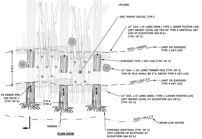
Post Assited Wicker Weaves (PAWW)
The PAWW that you see as part of the shoreline restoration project were built by park staff and volunteers. The vertical timbers are four inches in diameter and ten feet long. They are placed three feet apart and only three feet of each timber is exposed above the ground after placement. Logging slash is woven between the timber piles to complete the PAWW.

Keeping It Natural is Important
Using on-site natural materials to build these structures is advantageous over installing riprap (the use of large rocks to stabilize shorelines and prevent erosion).
These natural aggradation structures:
- Efficiently rebuild shorelines better than riprap. (Riprap is used primarily for armoring shorelines.)
- Work with the natural process of the lake and do not negatively impact the natural micro-habitats of the shoreline. This helps to ensure the health of the plants and animals around and in the lake. (If riprap was used it would, in effect, turn a sand beach into a rocky beach and change the micro-habitats of the beach.)
- Prevent the introduction of invasive species to the lake since all the materials used to make the structures are from the site. (Rock used in riprap often comes from off site and can increase the risk of introduction of new or invasive species.)
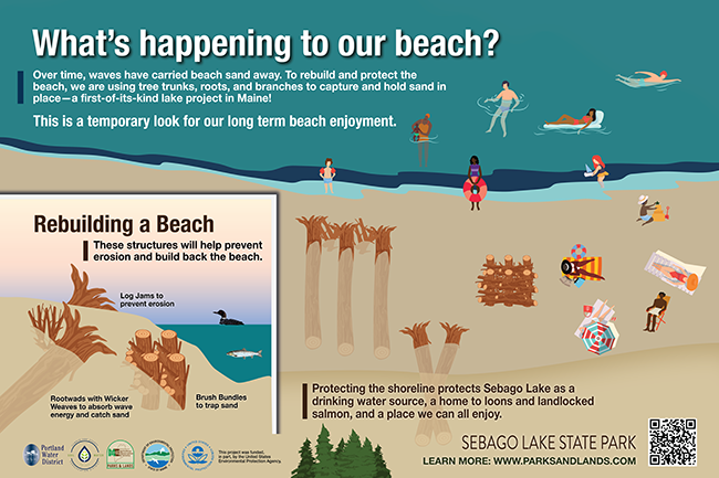
The picture above shows the beach restoration panel that is on site for visitors to read and connect to this webpage. For more information about this project contact Sebago Lake State Park at (207) 693-6231.
