DACF Home → Bureaus & Programs → Bureau of and Lands → Discover History & Explore Nature → History & Historic Sites → Allagash History
Allagash History
Prehistory
The area from which many lumber industries drew their wealth was previously the home of Native American tribes that archaeologists believe first settled in the region -- ten centuries before the lumbermen came. The tundra-like environment left by the last Ice Age finally yielded to dense forest in northern Maine about 10,000 years ago. Though a few families of Paleoindians may have traveled through the Allagash region at that time, the archaeological record shows a larger population during the Archaic period (10,000 to 4,000 years ago). The people of this era were generally nomadic, using nets for fishing and stone or wood tools. Most plentiful among the artifacts discovered from this period are stone axes and gouges for woodworking. Between 4,000 and 3,500 years ago these types of tools became less common, suggesting a shift from dugout canoes to a birch bark type. This view is also supported by a shift in the frequency of sites to drainage areas where heavier dugouts would not have been useful.
The Ceramic Period (3,000 to 500 years ago) is named for the emergence of the use of pottery. Though not very durable at this point, pottery enabled cooking directly on the fire, rather than the labor-intensive method of heating stones and placing them into a bark or wooden container. Although the Allagash region is not conducive to the long life of ceramic artifacts, archaeologists have found pottery here at least 2,000 years old.
According to Dr. Art Spiess of the Maine Historic Preservation Commission, “For most of prehistory, Maine’s Native American population supported itself by hunting, fishing, and gathering in band organized societies without complex political organization…Maine Native Americans always have been relatively mobile in lifestyle and lived in relatively small groups.” The archaeological record seems to indicate that traditional Native American's began to move away from the Allagash region early in the 1800s.
The Moir Farm
 Not
long after Native Americans moved elsewhere, in the years
just prior to the arrival of the big lumber operations, a
few new settlers filtered down into the Allagash region, particularly
from the settlements to the north along the St. John River.
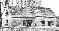
George Moir and Lucinda Diamond were among the area’s
earliest white settlers, reportedly arriving there in 1837
to establish what is now called the Moir Farm. It is from
them and other members of the Diamond family that many in
Allagash village are descended.
Not
long after Native Americans moved elsewhere, in the years
just prior to the arrival of the big lumber operations, a
few new settlers filtered down into the Allagash region, particularly
from the settlements to the north along the St. John River.
George Moir and Lucinda Diamond were among the area’s
earliest white settlers, reportedly arriving there in 1837
to establish what is now called the Moir Farm. It is from
them and other members of the Diamond family that many in
Allagash village are descended.
Business in the Allagash
At about the same time that Maine became a state (1820), a businessman from Salem, Massachusetts, named David Pingree, often called the “Merchant Prince of Salem,” foresaw the demise of his hometown as a major shipping port. Worrying about the future value of his vast shipping enterprises, he looked elsewhere for investment opportunities. Pingree was born in Bridgton, Maine, and, after moving to Salem to help manage his uncle’s large holdings, had little use for the drudgery of lumber work. In time, his uncle passed away and left his wealth to the nephew. Though skeptical at first, and prodded by others, his keen eye for commerce eventually gazed upon the seemingly unending tracts of timber-covered land in the northern half of the state. Basing his new enterprise in Bangor, a town that hosted more than three hundred sawmills by the mid-1830s, Pingree, under the guidance of his partner Ebenezer Coe, began to profit handsomely from his operations, wresting mighty trees from the virgin wilderness, running them down river to Bangor where they were milled into lumber and put aboard ships that could carry them wherever a market beckoned.
In 1837, the first of several financial panics struck the region, and though Bangor’s lumber interests suffered under competition from states to the west, Pingree expanded his holdings and pressed on. In time, he owned more than one million acres of Maine forestland, was the state’s largest taxpayer, and held more land than any other private entity in New England. Pingree’s investment in Maine timberland was so great that his heirs, now six generations later, are still the fourth largest private owners of land in the United States.
Pingree and others like him became the engines that drove the first large-scale incursion of non-native people into the Allagash region. The nation’s rapid expansion and an accompanying appetite for lumber helped spur the first stages of exploration and development that altered the landscape while opening the area to recreation, commerce and nearly an international war.
The Lumber Boom
One of the major impediments that limited the Bangor lumber interests’ ability to profit from Allagash timber was the fact that the water flowed northward into the St. John River. Once there, it could be turned into lumber in mills but the only route to sea transportation was by way of British-controlled seaports in Canada. Nature’s intended course for the waterway was not enough however, to deter the lumber barons for long. People whose ingenuity was only exceeded by their vision of large profits scoffed at Mother Nature’s plan for the river and sought to reverse the course of its flow, from northward to southward. By raising the level of the lakes and shifting the direction of the river current to the south, logs could be driven into the East Branch of the Penobscot River to Bangor where American millers and shippers could profit.
In the 1830s Amos Roberts and Hastings Strickland paid the State of Maine thirty five thousand, five hundred dollars to acquire Township 6- Range 11, a piece of land that contains the drainages into two major watersheds. These are Webster Lake, a headwater of the East Branch of the Penobscot River, and Telos Lake, which in its natural state is a headwater of the Allagash River. In order to get logs harvested from the area around Telos and Chamberlain Lakes down to the West Branch and thus into Bangor where American interests could profit, these owners needed to devise a way to move the logs from Telos over to Webster Lake.
In 1838 they engaged Shepard Body to devise a way to move logs from Chamberlain Lake into Telos Lake, then on to the East Branch basin. Body proposed the raising of waters in Chamberlain Lake via a dam and then the digging of a canal across the space between Telos and Webster Lakes. This area included a ravine that dropped approximately 47 feet into Webster Lake. By fall 1841 the two dams were in place and a canal ten to fifteen feet wide and one to six feet deep stretched the five hundred feet from Telos to Webster Lake. It was thereafter known as the Telos Cut.
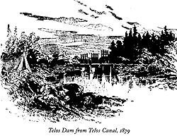 The
Telos Dam held back the lake’s water to create enough
force, upon release, to drive logs through the cut to Webster
Lake. It worked in conjunction with a canal (Telos Cut) and
a dam at the outlet of Chamberlain Lake to allow the water
in Chamberlain and Telos lakes to move south toward the Penobscot
River basin. The dam not only enabled its owners to control
the flow into the canal but also to collect a toll per thousand
board feet of lumber from any landowner along these lakes
who wanted to drive their logs to Bangor mills and markets.
However, it also made them dependent on the ability of the
Chamberlain Lake Dam (at the location now known as
Lock Dam) to retain enough water in Telos Lake to force the
move southward. This led to a series of controversies involving
owners of the Telos Dam and Cut and the other lumbering landowners
along Chamberlain and Telos Lakes.
The
Telos Dam held back the lake’s water to create enough
force, upon release, to drive logs through the cut to Webster
Lake. It worked in conjunction with a canal (Telos Cut) and
a dam at the outlet of Chamberlain Lake to allow the water
in Chamberlain and Telos lakes to move south toward the Penobscot
River basin. The dam not only enabled its owners to control
the flow into the canal but also to collect a toll per thousand
board feet of lumber from any landowner along these lakes
who wanted to drive their logs to Bangor mills and markets.
However, it also made them dependent on the ability of the
Chamberlain Lake Dam (at the location now known as
Lock Dam) to retain enough water in Telos Lake to force the
move southward. This led to a series of controversies involving
owners of the Telos Dam and Cut and the other lumbering landowners
along Chamberlain and Telos Lakes.
What abilities the Telos owners had in foresight and ingenuity, they seemed to lack in dam-building skills. While the Telos Dam held back the water with some success, the other dam in their newly devised system was not as reliable. The first dam washed out within a year, taking with it a portion of the shoreline. Its successor was thus more costly and fared little better, having been built too low. At this point, David Pingree and Eben Coe agreed to build a third dam and, by thus controlling the water from the larger Chamberlain Lake down to Telos, get a better toll rate from the owners of the Telos operation. Soon after Pingree and Coe built the third Chamberlain Lake Dam, Roberts and Strickland offered to sell the Telos operation to Pingree. After failing to agree with Pingree on a price, they sold the rights to Telos Canal to Rufus Dwinel, Pingree’s rival in the Bangor lumber industry. Dwinel then raised the toll for passage through the cut to thirty-four cents per thousand board feet. When Pingree cried “robbery” Dwinel claimed the refusal was a threat and raised the toll to fifty-cents in order to offset the cost of hiring armed guards to protect the Telos operation. The resulting clash of lumber titans would later be remembered as “The Telos War.”
Protecting Telos with a group of fifty to one hundred armed ruffians, Dwinel intended to enforce his new toll and assert his rights against those of the wealthy landowners. Pingree took his case to the Maine State Legislature, which passed two acts. The first allowed Dwinel to incorporate and set the toll at twenty-cents. If he refused, a second act would allow Pingree to incorporate the “Lake Telos and Webster Pond Sluicing Company” and open the canal to free access. Though he did not agree quietly and the arguments over the Telos operation lingered for years afterward, Dwinel was forced to concede. In the words of one historian, “The waters of the Allagash, diverted by the hands of man, continued to work for the Bangor loggers until all the pine had gone downriver.”
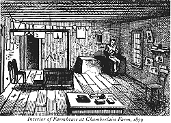 With their lumber operations expanding and reaching more deeply
into the wilderness region, Eben Coe built Chamberlain
Farm halfway up the eastern shore of Chamberlain Lake
in 1846. For Coe and Pingree, the farm provided a source of
hay and oats for workhorses, and winter vegetables for lumber
crews. It also served as a lumbering depot on Chamberlain
Lake.
With their lumber operations expanding and reaching more deeply
into the wilderness region, Eben Coe built Chamberlain
Farm halfway up the eastern shore of Chamberlain Lake
in 1846. For Coe and Pingree, the farm provided a source of
hay and oats for workhorses, and winter vegetables for lumber
crews. It also served as a lumbering depot on Chamberlain
Lake.
With the waterborne transportation system to the Penobscot basin in place and secure, lumber operations could expand further northward, widening the area from which they could be harvest timber. The same principles of water reversal led to the construction in 1846 of the Heron Lake Dam at the northern end of Heron and Churchill Lakes. This dam raised the water level of these two lakes, along with Eagle Lake, high enough to allow the passage of logs from Eagle over to Chamberlain, and thus down through Telos to Bangor. The only hurdle opposing this expansion, once the dam was in place, was the continuous strip of land that separated the two adjacent lakes. In the 1850s, Eben Coe went to work devising the first of several methods for moving logs over this barricade.
A few miles north of Chamberlain Farm Coe found a stream that connected a southern toe of Eagle Lake to Chamberlain. Here he decided to build a lock dam system with which he could move logs from one lake to the other by adjusting the water levels in the locks and floating groups of logs across. This process greatly expanded the acreage of timber that could be brought down to Bangor mills and markets, but the slow rate of the lock process limited the number of logs that could move through in a given period. It took a half-century for someone to devise a better system, but in 1902, with the help of steam-power, Fred Dow, an engineer for lumber barons H.W. Marsh and F.W. Ayer, constructed a tramway to do the job. Essentially, the tramway was a small railroad pulled by a cable loop six thousand feet long. Steel trucks attached to the cable carried logs across a three thousand foot passage at the northern end of Chamberlain Lake at the rate of about three miles per hour. As the logs dropped off on the western end, each empty truck looped underneath to a lower track and returned for another load. The tramway system worked remarkably well for five years.
In 1907, the St. John Lumber Company began construction on the Long Lake Dam and, after the first effort washed out in its first season, completed the project in 1911. This timber crib structure was made up of huge pine logs and cost a total of $50,000 and extended the duration of the company’s log drive above the lakes northward on the Allagash River. The dam was seven hundred feet across, held fifteen feet of water depth, and each of its eighteen gates were eight feet wide. When the gates were opened, the force was felt more than one hundred miles away at Van Buren. When the east side of the first dam collapsed in 1908, the water level at Fort Kent rose several feet.
The dam gave the lumber company better control of water flow down the Allagash River and added ten days to the drive. In better years, it was refilled three and four times during a single summer. It was so effective in the 1910s and 1920s that the dam was credited with stabilizing the economy of the upper St. John basin.
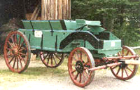 One of the tools that aided in the construction of the dam was
the Watson Bottom Dump Wagon. Built by the Watson Corporation
of Canastota, New York, (founded by David S. Watson) these
came out of the plant at a pace of 3,500 per year at its peak.
The unique bottom dump mechanism made it a useful tool in
various construction projects within the lumbering operations.
At one time, three of these wagons were stored at Churchill
Depot, but today one fully restored wagon and a collection
of parts from the other two remain. Tom Goodyear of Bangor,
Maine, and Seven Islands Land Company volunteered his time
and skills to restore this fully operational wagon.
One of the tools that aided in the construction of the dam was
the Watson Bottom Dump Wagon. Built by the Watson Corporation
of Canastota, New York, (founded by David S. Watson) these
came out of the plant at a pace of 3,500 per year at its peak.
The unique bottom dump mechanism made it a useful tool in
various construction projects within the lumbering operations.
At one time, three of these wagons were stored at Churchill
Depot, but today one fully restored wagon and a collection
of parts from the other two remain. Tom Goodyear of Bangor,
Maine, and Seven Islands Land Company volunteered his time
and skills to restore this fully operational wagon.
For those operations still driving logs south to Penobscot waters, the Eagle Lake and West Branch Railroad replaced the tramway in 1926 as the means of carrying logs from Eagle and Churchill Lakes. It ran from the Eagle Lake end of the tramway thirteen miles to Umbazooksus Lake, which connects to the Penobscot River via its west branch. “King” Edouard Lacroix’s Madawaska Company purchased a ninety-ton steam locomotive in New York and converted it from coal to oil burning for this operation. To haul the large supply of oil needed for the train, the company leased a Plymouth gasoline engine from Great Northern Paper. The oil was brought in barrels by truck from Greenville to Chesuncook Dam. From there, a scow would carry the barrels to the terminal end of the railroad on Umbazooksus Lake.
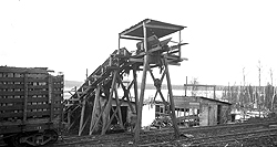 The logs were drawn up to the top of the cars along
two conveyors that raised them up twenty-five feet over a
two hundred twenty-five foot length. With a forty-horse power
diesel-burning engine powering each conveyor, a cord of wood
could move from lake to car in just ninety seconds. Each twelve-cord
car could be filled in eighteen minutes. Operators soon discovered
that the time it took to neatly pile the logs into the cars
horizontally made the practice inefficient, so they resorted
to just dumping them in as they fell from the conveyors. The
cars were built with a slight tilt in them so that when they
drove out onto the dumping site (where the tracks were tilted
still more) an operator could knock loose the pins holding
back the car wall hinged at the top and most of the load would
tumble out into the water. A little picking and prodding of
the remaining logs and the train was on its way back for another
load.
The logs were drawn up to the top of the cars along
two conveyors that raised them up twenty-five feet over a
two hundred twenty-five foot length. With a forty-horse power
diesel-burning engine powering each conveyor, a cord of wood
could move from lake to car in just ninety seconds. Each twelve-cord
car could be filled in eighteen minutes. Operators soon discovered
that the time it took to neatly pile the logs into the cars
horizontally made the practice inefficient, so they resorted
to just dumping them in as they fell from the conveyors. The
cars were built with a slight tilt in them so that when they
drove out onto the dumping site (where the tracks were tilted
still more) an operator could knock loose the pins holding
back the car wall hinged at the top and most of the load would
tumble out into the water. A little picking and prodding of
the remaining logs and the train was on its way back for another
load.
Since the round trip over the curvy road made a single-train operation too slow and inefficient, the company used two trains of ten cars each. In time, the work was increased until three trains of twelve cars each ran on the road both day and night. This, and the addition of electric lighting system for loading the cars along with storage towers to allow faster refilling of the trains’ water and oil increased the log-hauling capacity four hundred percent. In an average week, six thousand five hundred cords of wood moved across the tracks.
The railroad crossed over the northwest arm of Chamberlain Lake where it reaches toward Allagash Lake. The most significant structure of this operation was a fifteen hundred foot long railroad trestle sturdy enough to carry both the train and its regular supply of heavy log cargo across this piece of water.

As the needs of the lumbering industry changed and the types of wood harvested began to vary, it became important to find ways to haul logs across land in snow, mud, or dry ground. Hearing about this need on a train ride home to Waterville, engineer and inventor Alvin Lombard designed a track-driven locomotive that needed no rails, freeing it to range the Allagash wilderness.
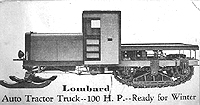 Lombard Log Haulers, produced in Lombard's Waterville
factory, featured the first-ever useable patent on a track-driven
vehicle. In 1903, the founders of the Caterpillar Corporation
paid Lombard $60,000 so they could produce vehicles under
his patent. Every track-driven vehicle in the world today,
including army tanks, snowmobiles, and heavy equipment, all
stem from Lombard’s original patented invention. Lombard’s
original hauler was driven by steam, but he continued to adapt
it to the times, eventually producing a gasoline-powered hauler
as well. The eventual arrival of gasoline-powered lumber trucks
rendered the Lombard’s obsolete, there are currently
a handful of these vehicles still in existence, mostly in
New England.
Lombard Log Haulers, produced in Lombard's Waterville
factory, featured the first-ever useable patent on a track-driven
vehicle. In 1903, the founders of the Caterpillar Corporation
paid Lombard $60,000 so they could produce vehicles under
his patent. Every track-driven vehicle in the world today,
including army tanks, snowmobiles, and heavy equipment, all
stem from Lombard’s original patented invention. Lombard’s
original hauler was driven by steam, but he continued to adapt
it to the times, eventually producing a gasoline-powered hauler
as well. The eventual arrival of gasoline-powered lumber trucks
rendered the Lombard’s obsolete, there are currently
a handful of these vehicles still in existence, mostly in
New England.
A number of small communities grew up in the early 1900s aroundlogging operations to supply the needs of the men working in these trades. J.T. Michaud, a lumber baron, established a farm on the upper reaches of the Allagash River to grow grain for his workhorses and vegetables for his work crews. He kept animals at the farm and ran a store for the families who lived and worked in the area, which was once a bustling little community of many as thirteen families. In the 1920s and 1930s, Michaud Farm became a base camp for lumber crews. When the St. John Lumber Company failed, so did the fortune of J.T. Michaud. The buildings (including one that served as a hotel for travelers), fell into disrepair and are all gone now. Today it is a camping and access site for canoers and the site of the last BPL Ranger Station on the waterway.
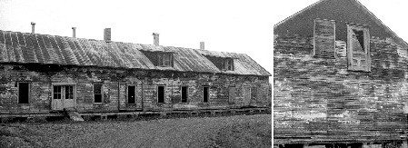
Dating from the 1920s, this boarding house was one structure among many that formed the Churchill Depot headquarters for Eduoard LaCroix’s lumbering operations in the Allagash region. The boarding house was capable of handling many people at one time, some of whom were transients going to or from lumbering camps, and others who were more or less permanent residents employed by LaCroix to keep his huge lumbering operation functioning.
This large structure, standing on the shores of the Allagash River adjacent to Churchill Dam, has been identified as a potential site for a small museum/exhibit area about the Allagash’s pre-history and history. For many years, the boarding house has been in a state of disrepair, requiring substantial structural and cosmetic work. A volunteer project, organized in 1996 by the Allagash Alliance, led to the replacement of foundation piers and sills. Work planned for the future includes replacement of exterior siding and windows, repainting, roof work, and interior refurbishment.
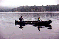 Early recreational visitors
to the Allagash relied on the facilities first built to serve
the timber industry. Dams built to float logs provided comparable
service for canoes. Chamberlain Farm and Churchill
Depot served as re-supply points and safe havens in the
woods. Eventually, purpose-built sporting camps were developed
along the waterway to serve the needs of hunters and fishermen.
Early recreational visitors
to the Allagash relied on the facilities first built to serve
the timber industry. Dams built to float logs provided comparable
service for canoes. Chamberlain Farm and Churchill
Depot served as re-supply points and safe havens in the
woods. Eventually, purpose-built sporting camps were developed
along the waterway to serve the needs of hunters and fishermen.
 Since the 1930s, recreational sporting camps have been a feature
of life on the Allagash waterway. Today, there are remnants
of these getaway destinations, some still in operation for
enthusiasts who enjoy canoeing, hiking, hunting, and fishing.
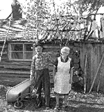
The remains of three log camps, built and occupied by former
Allagash game warden and guide, Henry Taylor and his wife
Alice (right), in the 1930s still stand on the Allagash River
today and are still referred to as the Henry Taylor Camps.
Since the 1930s, recreational sporting camps have been a feature
of life on the Allagash waterway. Today, there are remnants
of these getaway destinations, some still in operation for
enthusiasts who enjoy canoeing, hiking, hunting, and fishing.
The remains of three log camps, built and occupied by former
Allagash game warden and guide, Henry Taylor and his wife
Alice (right), in the 1930s still stand on the Allagash River
today and are still referred to as the Henry Taylor Camps.
Two other sporting camps, Jalbert’s and Nugent’s are now owned by the state and leased for operation. These two historic sporting camps were not eliminated after the Allagash was purchased by the State because they offered an alternative, traditional form of public recreational use of the Waterway, and because both provided a measure of safety for boaters on Chamberlain Lake and Round Pond.
In 1965, eight camps were owned and operated by Robert and Willard Jalbert, Jr., including five at Round Pond, two at Burntland Brook, and one at Whittaker Brook. In 1999, there were ten camps and structures at Jalbert’s, including those at Burntland Brook and Whittaker Brook. In 1965, there were twenty-six camps and structures at Nugent’s, including seventeen at the Chamberlain Lake camps. Today, there are twenty-five camps and structures at Nugent’s, excluding outhouses. In both instances, additional structures such as utility buildings, woodsheds, and outhouses were undoubtedly present in 1965 but were not identified.
The Allagash Today
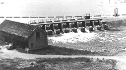 Originally known as Heron Lake Dam, Churchill Dam
was constructed in1846 to raise water levels in Eagle Lake
and Churchill Lake so that logs could be floated south from
Churchill and Eagle Lakes through Lock Dam and Telos Dam to
the East Branch of the Penobscot River. It was re-constructed
in 1925 by Great Northern Paper Company and was breached in
1958. A temporary tractor bridge existed across the natural
course of the river at its outlet from Heron Lake, which was
used until Daaquam Lumber, with design and engineering by
Great Northern Paper and the state’s approval, built
a new, timber-crib dam and bridge in 1968, 300 feet upstream
of the site of the breached dam. Shortly thereafter, the Parks
and Recreation Commission purchased the dam, along with the
Restricted Zone, and operated it to ensure an adequate flow
of water through Chase Carry Rapids for summer canoeing. Winter
water releases were sold by the state to New Brunswick Power,
until this practice was stopped at the request of the Inland
Fish and Game Department.
Originally known as Heron Lake Dam, Churchill Dam
was constructed in1846 to raise water levels in Eagle Lake
and Churchill Lake so that logs could be floated south from
Churchill and Eagle Lakes through Lock Dam and Telos Dam to
the East Branch of the Penobscot River. It was re-constructed
in 1925 by Great Northern Paper Company and was breached in
1958. A temporary tractor bridge existed across the natural
course of the river at its outlet from Heron Lake, which was
used until Daaquam Lumber, with design and engineering by
Great Northern Paper and the state’s approval, built
a new, timber-crib dam and bridge in 1968, 300 feet upstream
of the site of the breached dam. Shortly thereafter, the Parks
and Recreation Commission purchased the dam, along with the
Restricted Zone, and operated it to ensure an adequate flow
of water through Chase Carry Rapids for summer canoeing. Winter
water releases were sold by the state to New Brunswick Power,
until this practice was stopped at the request of the Inland
Fish and Game Department.
The deteriorating structural condition of the 1968 timber-crib dam caused the load limit rating of the bridge across the dam to be progressively reduced to six tons, eventually limiting the bridge to small trucks and passenger vehicles in 1995. The Bureau of Parks and Lands replaced the deteriorated, increasingly inoperable dam with a concrete structure in 1997. The new bridge deck was designed to carry off-road logging trucks and heavy forest fire fighting equipment, at the request of the Bureau of Forestry and forest landowners.
In 1960-61 Richard Gilman, a contractor for the Grafton Lumber Company built a bridge to haul timber across the narrow space of water between Round Pond and Churchill Lake. In 1964-65 the Cliff Lake gravel connection was linked to Gilman’s road making it possible for four-wheel drive vehicles to reach the area. In 1969-70 two Canadian brothers, Denis and Gilles Poulin, formed John’s Logging Company, naming this after the Pope, the slain President Kennedy, Governor John Reed of Maine, and several other John’s important to the brothers. The Johns Bridge was rebuilt and then named for the company. This connected it with the road system on the easterly side of the lakes, making it an important thoroughfare for sport fishing and lumber operations alike. The Seven Islands Land Company constructed the current bridge when the second John’s Bridge had deteriorated.
All along the Allagash Wilderness Waterway there are remnants and reminders of the long and active history of the region. In 1994, the bureau contracted with a knowledgeable individual, who was assisted by volunteers and Waterway staff, to inventory historical artifacts resting above ground along the Waterway. Since that time, three phases of the survey have been conducted. In all, twelve sites have been surveyed and mapped. Artifacts associated with each site have been numbered, photographed, and recorded. Survey records are housed in the Waterway office and in the bureau’s Augusta office.
The artifacts inventoried during this survey generally related to machinery, engines, and structures that served lumbering operations in the Waterway in the early decades of this century. Where possible, significant artifacts have been retrieved and stored in the barn at Churchill Depot for possible use in future historical exhibits.