Home → Bureaus & Programs → Bureau of Parks and Lands → Find Parks & Lands → Park Details
 Land and Water Conservation Fund
 Maine Trail Finder
 Northern Forest Canoe Trail
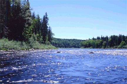
Description
Please check for access and COVID-19 updates by using this link. and text PRC to 888-514-7527 to subscribe to the park's Condition Alerts.
Lat 45.97546 / Lon -69.523756
Please review the Rules for the Penobscot River Corridor before you visit. They are specific to this waterway and supersede the standard Parks and Historic Sites rules.
Camping fees are listed under the River Camping section of this linked Campground Fees page. For more information contact the Northern Region Parks Office at (207) 941-4014.
Located in the heart of Maine's undeveloped forest land, the Penobscot River Corridor (PRC) provides outstanding opportunities for remote canoe trips, fishing excursions, and whitewater rafting (provided by commercial operators). Managed by the Bureau in cooperation with several landowners, the PRC provides water access recreation along more than 67 miles of river and 70 miles of lake frontage. Major access points in the area are gained from Millinocket or Greenville. Trips to this remote region require careful planning; contact the Bureau at (207) 941-4014 for more information.
For a guided tour of the region's geologic highlights, see Evidence for a calving embayment in the Penobscot River Valley, Bangor, Maine, or see Haskell Rock, East Branch Penobscot River, T5 R8 WELS. Learn about the geology of the area on the interactive Maine Geologic Facts and Localities map.
PLEASE NOTE:
Cell phone service should not be counted on in this area; service is spotty to non-existent. Plan your trip and emergency preparedness with this in mind; you will have to be able to reach a landline to call for help. The Maine Inland Fish and Wildlife Warden Service responds to search & rescue operations in the area. Dispatch Center phone numbers are listed on the Maine Warden Service website.
Trips to this remote region require careful planning; contact the Bureau at (207) 941-4014 for more information.
The Penobscot River Corridor is part of the Northern Forest Canoe Trail. The Northern Forest Canoe Trail is an historic 740-mile watertrail through New York, Vermont, Quebec, New Hampshire, and Maine.
The Penobscot River Corridor Map (1.73MB) is available for downloading in Adobe Portable Document Format (PDF). NOTE: This map is meant to be a general guide to the area, not an on-the-water map. If you cannot open these files, visit Adobe's website to download free Adobe Reader software for viewing and printing PDF files.
The Department of Agriculture, Conservation and Forestry contracts with North Maine Woods, Inc. for the collection of Penobscot River Corridor and Allagash Wilderness Waterway Fees.
The Land and Water Conservation Fund contributed to this State Park.Learn more about LWCF.
Activities
- Camping
- Canoeing
- Fishing
- Hiking (trails)
- Snowmobiling
- Swimming
- Watchable wildlife
Rules
Consider lending a hand. Contact us if you would like to help with stewardship or maintenance work.
Tours and Programs
View the Maine Parks and Lands EVENT CALENDAR
Services and Facilities
- Hand-carry boat launch
- Trailered boat launch
- See Visitor Accessibility
Special Considerations
Moving firewood can transport exotic insects & diseases that pose a serious threat to our forests. Don't transport firewood, buy it from a local source. Burn It Where You Buy It