Home → Bureaus & Programs → Bureau of Parks and Lands → Find Parks & Lands → Park Details
 Maine Trail Finder
![]() - download brochure (2,542 KB)
- download brochure (2,542 KB)
Description
Please check for access and COVID-19 updates by using this link to the Bureau's Safety page.
Location Lat 44.689169, Lon -67.398211 Five (5) miles south of Machias on Route 92.
Hours / Season Open 9:00 a.m. to sunset daily from Memorial Day to September 30th unless otherwise posted at the gate. Fee charged. Visitors may continue to enjoy the park during the off season by parking outside the gate and walking in during these same hours. Please be aware that facilities are closed during the off season.
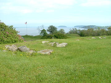
Fort O'Brien (Fort Machias) was built in 1775 and destroyed by the British in the same year. This state historic site is one of few Maine forts active during three wars - the American Revolution, War of 1812 and Civil War. Fort O'Brien's layout was altered several times over the 90 years it was active on this site. But the fort's important role in protecting the Machias River and its towns remained unchanged.
It was refortified in 1777 and destroyed once again by the British in 1814. Well-preserved earthworks which overlook Machias Bay were erected for a battery of guns in 1863. The first naval engagement of the Revolution was fought off-shore in 1775, five days before the Battle at Bunker Hill. In 1923, the United States Government deeded the site of Fort O'Brien to the State of Maine. First administered as a State Historic Site in 1966, it is now maintained by the Bureau of Parks and Lands.
If you are interested in learning about geology around the state, check out the Maine Geological Survey Searchable Database.
Download the Fort O'Brien State Historic Site brochure (PDF)
Rules
Consider lending a hand. Contact us if you would like to help with stewardship or maintenance work.
Services and Facilities
- Picnic area
- See Visitor Accessibility