Home → Bureaus & Programs → Bureau of Parks and Lands → Find Parks & Lands → Park Details
 Land for Maine's Future
 Maine Trail Finder
Description
Please check for access and COVID-19 updates by using this link to the Bureau's Safety page.
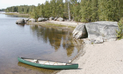
Lat 45.089221 Lon -67.862831 (Third Machias Lake access point)
The Machias River, one of Maine's wildest and most cherished waterways, flows for 76 miles from Fifth Machias Lake to tidewater in downtown Machias. The State oversees stewardship and recreational use along its nearly unbroken shoreline, thanks to a remarkable effort that has protected more than 60,000 acres in the Machias River watershed-the country's largest, self-sustaining wild Atlantic salmon run. This landscape-scale conservation project, which spanned more than a decade, successfully preserved 252 miles of river and shore frontage from development and subdivision, while ensuring that the region's working forests can keep contributing to the local economy. Recreational access is guaranteed for all time, helping to maintain a scenic and popular backcountry canoe route (considered by paddlers to be more accessible than the St. John and less heavily traveled than the Allagash).
The State owns 14,000 acres outright and holds the remaining lands under conservation easements that prevent development and greatly restrict timber cutting in a 1,000-foot corridor on both sides of the river's mainstem and major tributaries. Many minor tributaries and other headwaters are completely protected through conservation ownership-either in the State's Duck Lake Public Lands (west of Fourth Machias Lake) or in the 55,678-acre Downeast Lakes Community Forest that Downeast Lakes Land Trust owns and manages (along Wabassus, Pocumcus and West Grand Lakes). The State holds additional easements in the upper watershed, ensuring that 88 percent of the land base cannot be subdivided and developed-a critical factor in preserving the river's high water quality).
Conservation efforts along the Machias may help stabilize Maine's Atlantic salmon population (which has fallen precipitously since the 1980s). Among the state's eight wild Atlantic salmon rivers, the Machias contains the greatest amount of juvenile-rearing habitat and has the highest estimated smolt production. The river system also supports a rich array of wading birds, waterfowl, neotropical migrants and grassland species. In 2006, the American Bird Conservancy identified this Downeast Lakes region of Maine as a Globally Important Bird Area, noting the occurrence of at least 180 species of birds, including 23 warblers.
Land for Maine's Future This property was acquired in part with funds from the Land for Maine's Future program. For more information about the LMF program and the places it has helped to protect, please visit the LMF webpage.
History
The river's name derives from a Passamaquoddy Indian word meaning "bad little falls," which refers to a steep stretch of falls that now lies in downtown Machias-marking the river's transition to tidewater. The Machias River was a major travel route for Passamaquoddy Indians ("People of the Dawn"), who spent winters hunting and trapping in the north woods, and migrated each spring to the coast to gather plants and shellfish. Along the shores of Machias Bay, petroglyphs that date back 3,000 years-depicting animals and tribespeople-testify to the significance of this long-standing tradition.
Following the arrival of European settlers in the late 1700s, the Machias River became a vehicle for transporting timber from the North Woods to coastal saw mills (powered by the river's force). At the height of the lumbering boom, the Town of Machias had 20 sawmills processing lumber and exporting wood products.
In June 1775, the British armed schooner HMS Margaretta arrived in Machias escorting the sloops Polly and Unity to collect lumber from the river's sawmills for building British barracks back in Boston. Residents needed to trade lumber for critical supplies from the British but did not want to betray the American cause. Forty town residents seized the two sloops and successfully captured the Margaretta in what became the first naval battle of the American Revolution.
While timber is still a valuable resource harvested through much of the river's watershed, the log drives along the Machias River ended by 1970. The last logging dams were removed from the Machias in 1974, restoring the river to its free-flowing condition and improving navigability for recreational users and Atlantic Salmon.
The northern portions of the Machias River watershed, from Fifth to First Machias Lakes, have long been popular among fishermen and guides. Efforts to sustain this recreational resource, rich wildlife habitat and the surrounding productive forests began in the 1990s and culminated in 2008 with the completion of the third phase of the Machias River Project.
If you are interested in learning about geology around the state, check out the Maine Geological Survey Searchable Database.
Activities
- Camping
- Canoeing
- Fishing
- Hunting
- Swimming
- Watchable wildlife
Rules
- Kindle fires only in authorized campsites with fire rings and cut no live vegetation. Moving firewood can transport exotic insects & diseases that pose a serious threat to our forests. Don't transport firewood, buy it from a local source. Burn It Where You Buy It
- Carry out all trash.
- Although hunting is permitted, do not discharge weapons within 300 feet of any picnic area, camping area, parking area, posted trail or other developed area. Loaded firearms are not permitted at campsites or on hiking trails.
- Bureau of Parks and Lands staff may take custody of any personal property left unattended for more than 3 days (unless advance written permission is given).
Consider lending a hand. Contact us if you would like to help with stewardship or maintenance work.
Trails
The 76-mile canoe trip (with Class I-III whitewater, appropriate for experienced paddlers) begins at Fifth Machias Lake and reaches tidewater in Machias. The upper reaches of the river, between the five lakes, are narrow and have some stretches of rapids. The trip requires a minimum of six days to do in entirety, but can be split into two three-day trips (paddling the five lakes in the headwaters in one trip and the lower river on a second trip). Less experienced paddlers should engage a guide.
Services and Facilities
- Hand-carry boat launch
- See Visitor Accessibility
Special Considerations
The region's abundant moose, bear and other large animals can create hazards when in close contact with people (or their vehicles). Drive slowly on area roads (particularly at times of low light) and observe wildlife from a safe distance. Keep food items securely stowed when camping and make sure that tents and their contents are free of food and food odors.
Don't count on your cell phone in an emergency as coverage is spotty to non-existent.
Take care traveling along area logging roads, pulling over and stopping for trucks regardless of which direction they're headed as they have the right of way. Avoid roads that are too narrow for two vehicles, do not block side roads and never stop in a spot with poor visibility. Roads can be dusty in dry weather and washed out in wet weather. Gravel roads are hard on tires (and suspension systems): travel slowly and carry a spare tire.
When to Visit
Most paddlers travel the Machias River in May or early June (when water levels are adequate most years) but the upper lakes can be paddled throughout summer if there has been moderate rainfall. Be prepared for black flies and mosquitoes in May and June. Campers and ATV drivers enjoy the corridor all summer, while hunters arrive in October and November. Roads along the corridor are unplowed in winter so only snowmobiles can gain access then.