Home → Bureaus & Programs → Bureau of Parks and Lands → Find Parks & Lands → Park Details
 Land for Maine's Future
 Land and Water Conservation Fund
 Maine Trail Finder
Description
Location
Lat 44.261181 / Lon -70.187399
On Center Bridge Road off Route 4 in Turner.
Prepare for your visit Check the Bureau's Safety Page and text ANDRO to 888-514-7527 to subscribe to the park's Condition Alerts.
Hours/Season
Open all year; 9:00 a.m. to sunset daily unless otherwise posted at the gate. No fee is currently charged at this park.
The park is gated and accessible only for foot traffic between the end of snowmobile season and May 15. Visitors enjoy the Androscoggin Riverlands year-round, with skiers and snowmobilers using the trails in winters and a mix of hiking, boating and ATVs in warmer seasons (ATV use is allowed only between May 15 and December 15, unless otherwise posted). Hunting is popular on these lands so be sure to wear highly visible clothing in the fall.
The Park
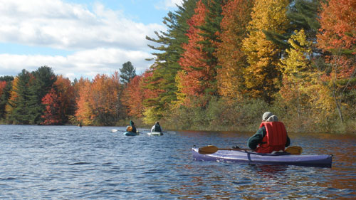
Lying near Maine's second largest urban area (Lewiston/Auburn), Androscoggin Riverlands State Park is a 2,675-acre expanse with 12 miles of river frontage. More than half of Maine's population lives within an hour drive of this park, which is the fifth largest in the State. An extensive trail network and undeveloped lands offer abundant recreational opportunities and habitat for wildlife. The park is part of the larger Androscoggin Greenway and the Androscoggin River Water Trail.
Turner Lands (2,345 acres): The larger of the park's two sections spans 6 river miles of gently rolling land along the Androscoggin's western shore in Turner. Visitors on foot, bicycle, ATV or horses can enjoy 12 miles of multi-use trails, and an additional 10 miles of foot trails (6.6 miles are shared with single-track biking) that offer great opportunities for spotting wildlife.
Leeds Lands (330 acres): The relatively flat and forested park lands along the east shore of the Androscoggin River is accessible by boat (primarily canoes and kayaks due to shallow water) and in winter by snowmobile.
Read the March 23, 2020 Rubys on the Road review of the park.
Partners and Supporters: The riverfront park was preserved as a natural area for public recreational use and conservation through the hard work and commitment of community residents and organizations. A broad Coalition of interests plans for the future of the river and the Androscoggin Greenway. Coalition members include local municipalities, the Androscoggin Land Trust, the Androscoggin River Watershed Council, the Androscoggin River Alliance, Androscoggin Valley Council of Governments, and the Maine Bureau of Parks and Lands. The Androscoggin Land Trust, The Nature Conservancy, and the Trust for Public Land helped negotiate land acquisitions, and the State's Land for Maine's Future Program as well as the National Park Service's Land and Water Conservation Fund helped support land purchases.
Land for Maine's Future This property was acquired in part with funds from the Land for Maine's Future program. For more information about the LMF program and the places it has helped to protect, please visit the LMF webpage.
The Land and Water Conservation Fund contributed to this State Park.Learn more about LWCF.
History
The Androscoggin, Maine's third largest river, begins in the mountains of New Hampshire and descends 164 miles and 1,500 vertical feet to Merrymeeting Bay. Native Americans camped and fished along its shores for at least 9,000 years and gave the river its name (meaning "plenty of fish" or "fish coming in spring").
The river's steep grade (an average of 8 feet per mile) made for challenging boat travel but helped power textile and paper mills. In 1925, Gulf Island Dam was built for hydropower production in Auburn - creating an impoundment that stretched 14 miles and forced the abandonment of riverside settlements.
Riverfront industries generated high volumes of pollution and by the 1960s, the Androscoggin was considered one of the ten most polluted rivers in the country. Pollutants built up behind the dams, diminishing water quality. The Clean Water Act in 1972 and subsequent reductions in industrial and municipal waste discharges helped water quality improve markedly.
Activities
- ATV riding
- Canoeing
- Cross-country skiing
- Fishing
- Hiking (trails)
- Horseback riding
- Hunting
- Kayaking
- Off-road biking
- Picnicking
- Snowmobiling
- Snowshoeing
- Watchable wildlife
Rules
- Motorized vehicles are allowed in the park only when conditions permit, generally between May 15 and December 15 (with snowmobiles permitted during the sledding season). Between the end of snowmobiling season and May 15, the property is gated by rule, with only foot traffic allowed.
- Park rules prohibit use of intoxicating beverages.
- Kindle fires only in authorized day-use settings with fire rings and cut no live vegetation.
- Carry out all trash.
- Stay on trails to protect sensitive ecosystems.
- Observe wildlife from far enough away that they do not change their behavior; do not follow or feed animals.
- Do not discharge weapons within 300 feet of any picnic area, parking area, posted trail or other developed area. Loaded firearms are not permitted on hiking trails.
- Park staff may take custody of any personal property left unattended for more than 3 days (unless advance written permission is given).
- Keep pets on leash (less than 4 feet) at all times and do not leave pets unattended.
- ATVs must use the north entrance parking area for off-loading.
- See Rules for State Parks and Historic Sites
Consider lending a hand. Contact us if you would like to help with stewardship or maintenance work.
Trails
12 miles of multiple use / shared use trails
10 miles of hiking trails (6.6 miles shared with mountain bikes)
6.6 miles of single-track mountain bike trails (existing and planned).
While there are many opportunities for trail-based recreation, not all trails are open to all uses. Please see the map to help determine which trails are the most appropriate for your chosen activity.
Multi-Use Trail (9.5 miles one-way), a central spine down the Turner parcel, is popular among ATV users, snowmobilers, bicyclists, horseback riders, and hikers. ATVs must use the north entrance parking area for off-loading.
Homestead Trail (4.5-mile loop with a 2.6-mile option; allow 2.5 hours for full loop) provides riverside hiking form the northern parking lot to the Picnic Meadow (1.1 mi.), where you can take the "Harrington Trail" (0.5 mi) and Multi-Use Trail back to the parking area (1.0 mi.). To extend your hike, continue south on the trail past Picnic Meadow to the juncture with the Multi-Use Trail that leads back to the main entrance (1.8 mi.).
Ridge Trail (6.85 miles) is reached by following the extended Homestead Trail to the Multi-Use Trail (2.0 mi.). Turn left, proceed over a bridge, turn right and continue up to a ledge outcrop overlooking the river (1 mi.). Turn left and descend steeply toward the river on the Ledges Trail (0.4 mi). Turn left on the Multi-Use Trail and return 2.25 miles to the Picnic Meadow, and on to the parking area via the Homestead Trail (1.1 mi.).
Deer Path Trail (8.0 miles) adds an additional loop beyond the Ledges Trail, with the Bradford Loop Trail (0.5 mi) that connects with the Deer Path Trail. At 1.5 miles, bear right at a fork and follow 0.5 mi to Multi-Use Trail. Return via the Homestead Trail (2.0 mi).
Bradford Loop Trail (12.2-mile loop) requires advanced ATV and snowmobiling riding skills. It can be accessed from the north end of the Park by following the Multi-Use Trail.
Bradford Hill Trail (variable length trips, starting with a 9.6-mile loop) offers hiking from the Conant Road entrance. Follow the Multi-Use Trail approximately 3.8 miles, turn left onto Bradford Hill Trail, then turn right on the Bradford Loop Technical Trail and follow the Multi-Use Trail back to the parking area.
Pine Loop Trail (5.7-mile round trip) from the Conant Road parking lot runs along the river. Hike along the Multi-Use Primitive Trail 1.6 miles (please see the map - this is a rough trail section), then veer right to reach the Pine Loop Trail.
View the Androscoggin Riverlands State Park snowshoe trail map at Maine Trail Finders.
Tours and Programs
Year-at-a-Glance Event Calendar for the State Parks, Historic Sites and Public Lands
Services and Facilities
- Hand-carry boat launch
- See Visitor Accessibility
Special Considerations
When boating or hiking, be prepared with extra clothing (and appropriate footwear), map and compass, and adequate water and food. Inform someone where you are going and when you expect to return.
Thoroughly clean boats and motors to avoid importing invasive plant and animal species.
The Maine Department of Inland Fisheries and Wildlife (MDIFW) Warden Service enforces state fish and game laws, boating laws (on inland waters), and ATV and snowmobile laws. To learn more about applicable laws and to purchase appropriate licenses, visit back to top)