
Sign Up for Email Alerts
Updates & News
- Updates
- News Releases
Updates
Select an update below to view details.
MaineDOT has launched an Interactive Virtual Public Meeting Story Map, including the Public and Agency Information Document and a letter from the MaineDOT Commissioner to the Towns of Machias and Marshfield, laying out next steps for the project process.
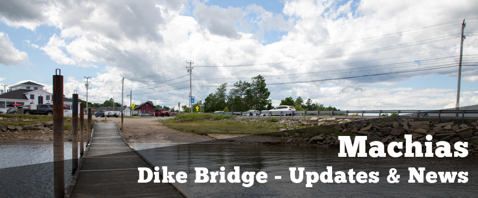
The Maine Department of Transportation is taking action to preserve the safety and reliability of the Machias Dike Bridge after recent inspections showed increasing voids within the structure. Part of the shoulder and parking area on the southbound (upstream) side of the bridge are being closed today. In the coming months, the department is planning to put a temporary bridge over the existing structure to maintain traffic on the bridge and adjacent Sunrise Trail. The construction of this temporary bridge will result in the closure of Route 1 for approximately one week.
Bridge inspectors observed areas of concern during a routine bridge inspection in September. Divers returned to the area last week and observed new areas of soil loss between the concrete slab (under the road surface) and the timber that forms the top of the gated boxes. Additionally, MaineDOT is changing its preferred alternative for the replacement of the Machias Dike Bridge. MaineDOT’s new preferred alternative involves the continued use of fully gated culverts. The Machias Dike Bridge carries Route 1 over the Middle River in the Town of Machias. The current structure dates to the Civil War era and is deteriorating. For the past several years, MaineDOT has been undertaking a feasibility study to improve or replace the existing bridge. In the last 16 months, MaineDOT has continued to receive public and stakeholder input.
The department has conducted an investigation of the former municipal landfill site and asked federal resource agencies, including the National Marine Fisheries Service, for clarifying information. Community stakeholders and landowners adjacent to the Middle River have repeatedly expressed concerns about the flooding that would be associated with a bridge alternative. This flooding would impact private property and the former landfill location. While MaineDOT realizes that some stakeholders may prefer a bridge alternative and tidal restoration, the department believes a fully gated culvert alternative will best meet the project’s purpose and need. This alternative will improve the structure’s condition, maintain the Sunrise Trail, provide for future rail use, and avoid flooding hundreds of acres of land.
MaineDOT will prepare a draft Environmental Assessment of the gated culvert alternative under the National Environmental Policy Act. The department intends to hold a public meeting on the draft Environmental Assessment in early 2024. This project should be entering the design phase by this time next year.
MaineDOT is continuing to work on the Machias Dike Bridge Feasibility Study including preparation of an Environmental Assessment (EA) under the National Environmental Policy Act (NEPA). MaineDOT anticipates publishing and holding a public meeting and public comment period on the draft EA some time in 2023. The study schedule and alternative evaluation remain dynamic as MaineDOT gathers additional information including public comments on study alternatives. Consistent with NEPA, MaineDOT and the Federal Highway Administration (FHWA) continue to evaluate the transportation alternatives that meet the project purpose and need which could impact the study schedule. For instance, during a June 2022 public meeting, MaineDOT received a number of substantive comments regarding the former municipal landfill and spent several months conducting an in-depth analysis, the results of which are available at the Machias Dike Bridge Project page. Current study efforts include the following:
- Receiving and responding to questions and comments on study materials including, but not limited to, the Machias Landfill Report.
- Discussing and receiving feedback with municipalities, project stakeholders, and partner state agencies.
- Sharing input received and requesting additional information from federal resource agencies. MaineDOT and FHWA are planning on submitting a biological assessment for the in-kind replacement alternative in early 2023 in pursuit of a biological opinion detailing the effects of that alternative on the endangered Atlantic salmon. The consultation process and biological opinion will help inform the NEPA process. We anticipate this process will take approximately months.
Please note that MaineDOT has not changed its position on a bridge as the study preferred alternative. However, MaineDOT understands the importance of the Dike Bridge and Causeway to Downeast Maine. In particular, MaineDOT has received a lot of feedback regarding potential property impacts of alternatives under consideration in Marshfield and Machias. Therefore, the department will continue to gather information and will evaluate the transportation alternatives based on feedback and, in particular, new substantive information received during the EA process. Any individual or party with questions on the study or wishing to make any formal project comments should continue to contact Martin Rooney, MaineDOT’s Feasibility Study Project Manager, via the information below.
Martin Rooney
Bureau of Planning - MaineDOT
Phone: 207-624-3317
Email: martin.rooney@maine.gov
- Reduced number of alternatives on the matrix by grouping by structure type. To eliminate duplication from previous studies and allows for clearer comparison of potential impacts.
- Evaluation of alternatives shifted to box culvert alternatives or bridge alternatives; less preference for in-kind due to potential impacts to Atlantic salmon and its critical habitat.
- Data collection on wells, hazardous materials and waste sites, and tidal exchange continues to refine flooding/property impacts of the box culvert and bridge alternatives.
- Hydraulic modeling refined to characterize fish passage improvements with box culvert and bridge alternatives.
- Coordination and technical assistance from NOAA underway to identify potential effects to Atlantic Salmon critical habitat (safe, timely, and efficient fish passage).
- Expanded survey of National Register-eligible properties to include areas potentially affected by a bridge alternative and any potential improvements at Stride Bridge.
- Coordination with Maine Historic Preservation continues, as well as with FHWA Historical and Cultural experts.
- Considering feasibility of Sea Level Rise accommodation for bridge and culvert options.
- Legal Research underway to understand railroad requirements and design implications for alternatives.
- Legal research underway on options for compensation of property owners related to flooding.
- Characterize existing uses of the causeway and community needs
- Tracking other efforts in the area (Downeast Salmon Federation Schoppee Marsh
News Releases
- There are currently no press releases posted.