Home → Hunting & Trapping → Hunting → Game Species → Deer → Expanded Archery Season on Deer → Lewiston Area
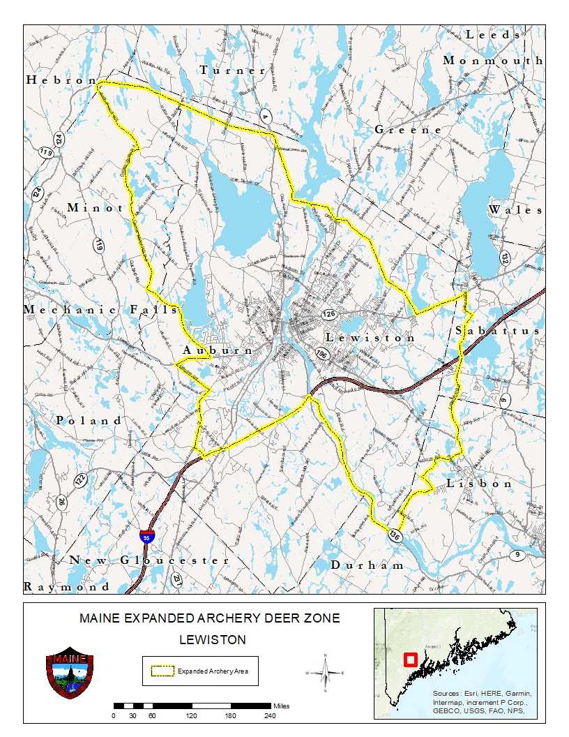
Boundary Description for the Expanded Archery Season on Deer - Lewiston Area
To view PDF documents, you will need the free Adobe Reader. If you need assistance, view our PDF Help page, or email us.
Portions of Auburn, Hebron, Lewiston, Lisbon, Minot, and Sabattus:
Beginning at the junction of Interstate Highway #495 and the Androscoggin River in Lewiston; then following the Androscoggin River southerly approximately five miles to a point directly south of the southern terminus of Hatch Road in Lisbon; then overland northerly to the southern terminus of Hatch Road; then following Hatch Road northerly to Ferry Road; then following Ferry Road westerly to Pinewoods Road; then following Pinewoods Road northeasterly to Cotton Road; then following Cotton Road northwesterly and beyond its terminus to the crossing with Salmon Brook; then following Salmon Brook northeasterly to the crossing of Moody Road; then following Moody Road easterly to State Route #196 (Lisbon Street); then following State Route #196 northerly to Littlefield Road; then following Littlefield Road northerly to Lisbon Road in Sabattus; then following Lisbon Road northerly to State Route #126; then following State Route #126 southwesterly to the double Central Maine Power line in Lewiston; then following the power line northwesterly and then westerly to the southwest corner of Gulf Island Pond on the Androscoggin River; then following the power line northwesterly and then westerly to Brighton Hill Road; then following Brighton Hill Road southeasterly to Death Valley Road; then following Death Valley Road southerly to Marstons Hill Road; then following Marstons Hill Road southerly to Center Minot Hill Road; then following Center Minot Hill Road southerly to Garfield Road; then following Garfield Road southeasterly to Minot Avenue; then following Minot Avenue westerly to Merrow Road; then following Merrow Road southeasterly to Hotel Road; then following Hotel Road southerly to Kitty Hawk Avenue; then following Kitty Hawk Avenue southeasterly to Interstate Highway #495; then following Interstate Highway #495 northeasterly to the point of origin at the junction of Interstate Highway #495 and the Androscoggin River in Lewiston.