See the maps posted periodically
throughout the late winter and early
spring.
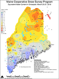
The Maine Cooperative Snow Survey collects, interprets, and distributes information on the depth and water content of Maine's snowpack in the late Winter and early Spring, when the danger of flooding in Maine's rivers and streams is greatest. The data are obtained from a number of cooperating sources, including:
- Allagash Wilderness Waterway
- Brookfield Renewable Energy Group
- Cobbossee Water District
- College of the Atlantic
- Great River Hydro, LLC
- Maine Environmental Science Academy - Fryeburg
- Maine Forest Service
- Maine Geological Survey
- National Weather Service Forecast Office, Caribou
- National Weather Service Forecast Office, Gray
- Nestle - Poland Spring Water Company
- New Brunswick Environment and Local Government
- New Hampshire Department of Environmental Services
- SAPPI Limited
- U.S. Geological Survey, New England Water Science Center, Maine Office
- University of Maine - Earth and Climate Science
The data are analyzed by staff from the Maine Geological Survey and U.S. Geological Survey, and maps are prepared showing the water content in the snowpack for the State. This information is transmitted to the National Weather Service (NWS) for use in preparing flood potential statements and running flood forecast models. In the event of a significant flood, the NWS would use the data to refine its estimates of flood crests. The data are also distributed to the Maine Emergency Management Agency (MEMA) and, through MEMA, to county emergency management officials.
Additional information on snowpack in Maine can be found at the National Weather Service Caribou Office web site on their snow information page. The National Weather Service Northeast River Forecast Center in Taunton, MA, has regional snowpack information on their web site. Select the snow information option from the sidebar menu.
Advances in remote sensing and satellite technology are allowing the National Oceanic and Atmospheric Administration to provide regional overviews of snow cover and water content for the Northeast , but until significant improvements are made in this technology, the maps you can view from this page provide the most detailed estimate of the rapidly changing water content in Maine's snowpack.