Home → Programs & Resources → Environmental Review → MDIFW Data → Accessing Data
Accessing Data
Fisheries and Wildlife Data Hub
Explore and engage with GIS data, discover apps, and collaborate on projects. Learn about the various fish and wildlife datasets, how to access data, and participate in the Department’s initiatives through the data hub. This site offers story maps, GIS data, project specific dashboards, Department mapping applications, data collection forms, and more.
Open the Maine Department of Inland Fisheries and Wildlife Data Hub
Providing public access to habitat data is not intended as a substitute for consultation with Maine Department of Inland Fisheries and Wildlife staff regarding environmental reviews.
Other Methods
Geographic Information System [GIS] Format (requires GIS software):
- Maine Office of GIS (shapefile (ArcGIS), KML (Google Earth), web service (REST))
- CD (shapefile copies)
GoogleEarth format (KML files)
Paper Maps
- Request a map from a MDIFW Regional Office
- Beginning With Habitat Maps (organized towns only)
MDIFW's wildlife/habitat data are updated as new information becomes available. The shapefiles available from the Maine Office of GIS are our most current data; we recommend that users refresh copies of these data at least annually (the metadata for each shapefile indicates when it was last updated by MDIFW).
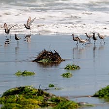
Photo Credit: Jonathan Mays, MDIFW
CD Request
To request a digital copy of MDIFW’s wildlife/habitat data, send an email to Amy.Meehan@maine.gov.
Please write “Data Request – Your Name” in the email subject line to help us track and save the request.
In the body of the email message, please indicate:
- Data sets of interest (list individual data sets or just indicate “all”):
- Piping Plover/Least Tern Essential Wildlife Habitat
- Roseate Tern Essential Wildlife Habitat
- Inland Waterfowl / Wading bird Habitat
- Tidal Waterfowl / Wading bird Habitat
- Shorebird Areas
- Deer Wintering Areas
- Seabird Nesting Islands
- Significant Vernal Pools
- Endangered, Threatened, & Special Concern Species
- Geographical area of interest. Include either a list of townships or attach a GIS shapefile.
- Your contact information including address, phone number, and email.
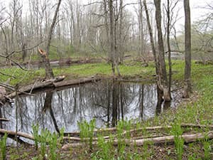
Photo Credit: Phillip deMaynadier, MDIFW
Data will be shipped as ESRI GIS shapefiles, UTM NAD83 Zone 19N. Each data set will have attached metadata. You must have GIS software to use this data!
If the requested data is small enough to email, it will be emailed to you. Otherwise a CD will be sent via regular mail.
We will make every attempt to process data requests as quickly as possible. If you need data faster, please consider using the MEGIS data catalog or GoogleEarth.
MDIFW's wildlife/habitat data are updated as new information becomes available. The shapefiles available from the Maine Office of GIS are our most current data; we recommend that users refresh copies of these data at least annually (the metadata for each shapefile indicates when it was last updated by MDIFW).
GoogleEarth

MDIFW recognizes that many potential data users do not have access to GIS software and that GoogleEarth is a popular alternative. MDIFW therefore provides copies of its wildlife/habitat data sets in GoogleEarth (KML) format, but users assume all responsibility for using GoogleEarth in accordance with its license restrictions. Please go to GoogleEarth’s website to learn about their software and licensing rules.
Note that MDIFW has limited control over how these KML files will display in GoogleEarth and cannot insert appropriate language concerning the meaning of the data into any maps printed using GoogleEarth.
MDIFW's wildlife/habitat data are updated as new information becomes available. The shapefiles available from the Maine Office of GIS are our most current data; we recommend that users refresh copies of these data at least annually (the metadata for each shapefile indicates when it was last updated by MDIFW).