August 4, 2016 at 3:23 pm
By Regional Wildlife Biologist Allen Starr
 Imagine an area that could provide an opportunity to hunt or view any of Maine’s big game species, pursue a variety of small game (including waterfowl), search for a plethora of songbirds, access a large, scenic river for boating and fishing or visit rare and exemplary natural communities and ecosystems. The Mattawamkeag River WMA, located in Drew Plantation, Kingman, Webster Plantation and Prentiss Township, is just such an area.
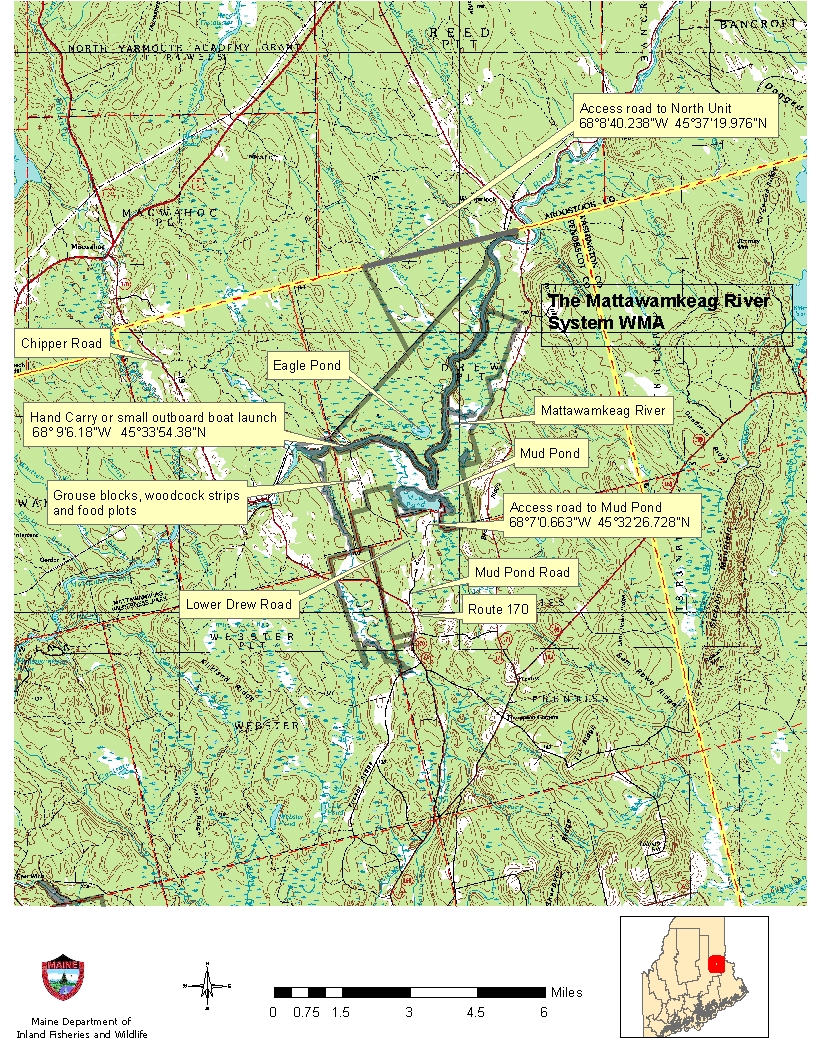
This management area is over 11,000 acres, is bisected by the Mattawamkeag River and is composed of four management units. Areas north of the Mattawamkeag River are in the Mattawamkeag North Unit, the Mattagodas Stream Unit encompasses areas surrounding Mattagodas Stream, old farm land on the western side of the management area constitutes the Page Farm Unit and all other ownership on the south side of the Mattawamkeag River is considered the Mattawamkeag South Unit. Each unit has unique wildlife, wildlife habitats or natural communities and are managed to benefit the greatest variety of wildlife, a specific species of wildlife or to conserve a unique natural area.
The North Unit is about 6000 acres on the north side of the Mattawamkeag River. It contains a 46-acre pond (Eagle Pond) and is primarily wetlands on the south side of the Eastern Maine Railroad tracks. Most of the area south of the tracks contains a rare natural community identified as an Unpatterned Fen Ecosystem and there is about 350 acres of upland adjacent to the wetlands. These wetland areas are also mapped as Inland Waterfowl and Wading Bird Habitats. The best way to access this portion of the North Unit is by watercraft from the Mattawamkeag River. There is road access to another portion of the North Unit using forest products company roads. Take the Chipper Road off Route 170 in Kingman and follow a series of dirt roads for about 7.5 miles that head for the Reed Plantation town line. Just prior to the town line, a road to the right provides access to this portion of the management area (coordinates provided on map). This dirt road is not maintained and travel becomes more difficult after crossing the bridge on Meadow Brook. There are a couple of mapped, Deer Wintering Areas in this part of the unit and an Inland Waterfowl Wading Bird Habitat along Meadow Brook. Meadow Brook also supports a wild brook trout population. Potential activities in the upland areas include: hunting for black bear, deer, birds and even a chance to hunt or view moose. Or, through a canoe on Meadow Brook for some waterfowl hunting, trout fishing or wildlife viewing.
Imagine an area that could provide an opportunity to hunt or view any of Maine’s big game species, pursue a variety of small game (including waterfowl), search for a plethora of songbirds, access a large, scenic river for boating and fishing or visit rare and exemplary natural communities and ecosystems. The Mattawamkeag River WMA, located in Drew Plantation, Kingman, Webster Plantation and Prentiss Township, is just such an area.
This management area is over 11,000 acres, is bisected by the Mattawamkeag River and is composed of four management units. Areas north of the Mattawamkeag River are in the Mattawamkeag North Unit, the Mattagodas Stream Unit encompasses areas surrounding Mattagodas Stream, old farm land on the western side of the management area constitutes the Page Farm Unit and all other ownership on the south side of the Mattawamkeag River is considered the Mattawamkeag South Unit. Each unit has unique wildlife, wildlife habitats or natural communities and are managed to benefit the greatest variety of wildlife, a specific species of wildlife or to conserve a unique natural area.
The North Unit is about 6000 acres on the north side of the Mattawamkeag River. It contains a 46-acre pond (Eagle Pond) and is primarily wetlands on the south side of the Eastern Maine Railroad tracks. Most of the area south of the tracks contains a rare natural community identified as an Unpatterned Fen Ecosystem and there is about 350 acres of upland adjacent to the wetlands. These wetland areas are also mapped as Inland Waterfowl and Wading Bird Habitats. The best way to access this portion of the North Unit is by watercraft from the Mattawamkeag River. There is road access to another portion of the North Unit using forest products company roads. Take the Chipper Road off Route 170 in Kingman and follow a series of dirt roads for about 7.5 miles that head for the Reed Plantation town line. Just prior to the town line, a road to the right provides access to this portion of the management area (coordinates provided on map). This dirt road is not maintained and travel becomes more difficult after crossing the bridge on Meadow Brook. There are a couple of mapped, Deer Wintering Areas in this part of the unit and an Inland Waterfowl Wading Bird Habitat along Meadow Brook. Meadow Brook also supports a wild brook trout population. Potential activities in the upland areas include: hunting for black bear, deer, birds and even a chance to hunt or view moose. Or, through a canoe on Meadow Brook for some waterfowl hunting, trout fishing or wildlife viewing.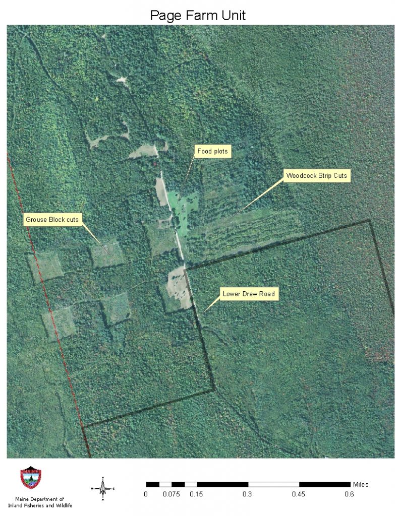 The Mattagodus Unit contains a variety of rare plants including Shrubby Cinquefoil, which is the sole larval host plant for Clayton’s Copper Butterflies. Clayton’s copper butterflies are currently known to occur in only eleven sites worldwide – nine
in Maine and just two sites in New Brunswick. Clayton’s Copper is listed as a Threatened Species in Maine. Protecting endangered and threatened species and their habitats is the highest priority for this unit by maintaining riparian buffers along Mattagodus Stream. The best way to access this unit is via canoe by launching from the bridge that crosses the Mattagodus Stream on Route 170 in Webster Plantation. Make sure to take along a fishing pole, this stream also supports a wild brook trout population.
The Page Farm Unit is where our most active habitat management is occurring, food plots have been
The Mattagodus Unit contains a variety of rare plants including Shrubby Cinquefoil, which is the sole larval host plant for Clayton’s Copper Butterflies. Clayton’s copper butterflies are currently known to occur in only eleven sites worldwide – nine
in Maine and just two sites in New Brunswick. Clayton’s Copper is listed as a Threatened Species in Maine. Protecting endangered and threatened species and their habitats is the highest priority for this unit by maintaining riparian buffers along Mattagodus Stream. The best way to access this unit is via canoe by launching from the bridge that crosses the Mattagodus Stream on Route 170 in Webster Plantation. Make sure to take along a fishing pole, this stream also supports a wild brook trout population.
The Page Farm Unit is where our most active habitat management is occurring, food plots have been 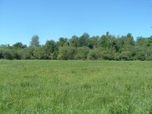 established to benefit deer, bear, turkeys and various non-game species. Apple trees have been pruned and released; fruit trees (hard and soft mast) have been planted and the fields that have not been planted with herbaceous seed are mowed annually. Habitat improvement practices for upland birds include creation of five acre block cuts to benefit ruffed grouse and strip cuts to benefit American woodcock; this is an excellent area to pursue upland birds with dogs. These two practices also provide early successional habitat for numerous songbirds and good cover for snowshoe hares. Traveling on the Lower Drew Road beyond the fields leads to the shores of the Mattawamkeag River, here a canoe or small boat can be launched to pursue smallmouth bass, hunt for waterfowl or to observe the abundant diversity of wildlife that inhabits the riparian areas of the river. This launch site is adjacent to a private camp, so please be courteous when accessing the river here.
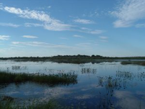
Finally, the Mattawamkeag South Unit encompasses all areas east of the Page Farm Unit on the south side of the Mattawamkeag River. The majority of unit is comprised of various wetland types and is a candidate Eco Reserve area due to the presence of rare plants, natural communities and unique wildlife. There are two ponds located within the unit, Benson Pond, an 18-acre pond surrounded by wetlands with walk-in access and Mud Pond, a 250-acre pond with emergent vegetation which provides important spring migration and feeding habitats for a variety of waterfowl and shorebirds. Mud Pond contains good interspersion of vegetation and open water, which provides excellent waterfowl/wading bird brood rearing habitat. Many aquatic furbearers inhabit the Mud Pond area, as well. There is road access to Mud Pond, although it is a not that obvious, at the end of the Mud Pond Road adjacent to an agricultural field (see coordinates on map). The road borders the field on the east side and can be wet during spring and fall rainy periods. Care should be taken when traveling along the field edge, the agricultural field is privately owned with a legal Right of Way for access. At the end of the field, a small woods road leads to a hand-carry boat launch on the southeastern side of Mud Pond. The pond provides an excellent opportunity for waterfowl hunting or bird watching and even the occasional moose or deer can be spotted on the shoreline. The rest of this unit is probably best accessed by watercraft from the Mattawamkeag River, unless you like trudging through wetlands!
The Mattawamkeag River System WMA provides a wealth of outdoor recreational opportunities and unique natural habitats to be explored. Whether you’re hunting for black bear, photographing a black tern or visiting a rare ecosystem, make a day of it and take advantage of what this area has to offer!
established to benefit deer, bear, turkeys and various non-game species. Apple trees have been pruned and released; fruit trees (hard and soft mast) have been planted and the fields that have not been planted with herbaceous seed are mowed annually. Habitat improvement practices for upland birds include creation of five acre block cuts to benefit ruffed grouse and strip cuts to benefit American woodcock; this is an excellent area to pursue upland birds with dogs. These two practices also provide early successional habitat for numerous songbirds and good cover for snowshoe hares. Traveling on the Lower Drew Road beyond the fields leads to the shores of the Mattawamkeag River, here a canoe or small boat can be launched to pursue smallmouth bass, hunt for waterfowl or to observe the abundant diversity of wildlife that inhabits the riparian areas of the river. This launch site is adjacent to a private camp, so please be courteous when accessing the river here.
Finally, the Mattawamkeag South Unit encompasses all areas east of the Page Farm Unit on the south side of the Mattawamkeag River. The majority of unit is comprised of various wetland types and is a candidate Eco Reserve area due to the presence of rare plants, natural communities and unique wildlife. There are two ponds located within the unit, Benson Pond, an 18-acre pond surrounded by wetlands with walk-in access and Mud Pond, a 250-acre pond with emergent vegetation which provides important spring migration and feeding habitats for a variety of waterfowl and shorebirds. Mud Pond contains good interspersion of vegetation and open water, which provides excellent waterfowl/wading bird brood rearing habitat. Many aquatic furbearers inhabit the Mud Pond area, as well. There is road access to Mud Pond, although it is a not that obvious, at the end of the Mud Pond Road adjacent to an agricultural field (see coordinates on map). The road borders the field on the east side and can be wet during spring and fall rainy periods. Care should be taken when traveling along the field edge, the agricultural field is privately owned with a legal Right of Way for access. At the end of the field, a small woods road leads to a hand-carry boat launch on the southeastern side of Mud Pond. The pond provides an excellent opportunity for waterfowl hunting or bird watching and even the occasional moose or deer can be spotted on the shoreline. The rest of this unit is probably best accessed by watercraft from the Mattawamkeag River, unless you like trudging through wetlands!
The Mattawamkeag River System WMA provides a wealth of outdoor recreational opportunities and unique natural habitats to be explored. Whether you’re hunting for black bear, photographing a black tern or visiting a rare ecosystem, make a day of it and take advantage of what this area has to offer!
Imagine an area that could provide an opportunity to hunt or view any of Maine’s big game species, pursue a variety of small game (including waterfowl), search for a plethora of songbirds, access a large, scenic river for boating and fishing or visit rare and exemplary natural communities and ecosystems. The Mattawamkeag River WMA, located in Drew Plantation, Kingman, Webster Plantation and Prentiss Township, is just such an area.
This management area is over 11,000 acres, is bisected by the Mattawamkeag River and is composed of four management units. Areas north of the Mattawamkeag River are in the Mattawamkeag North Unit, the Mattagodas Stream Unit encompasses areas surrounding Mattagodas Stream, old farm land on the western side of the management area constitutes the Page Farm Unit and all other ownership on the south side of the Mattawamkeag River is considered the Mattawamkeag South Unit. Each unit has unique wildlife, wildlife habitats or natural communities and are managed to benefit the greatest variety of wildlife, a specific species of wildlife or to conserve a unique natural area.
The North Unit is about 6000 acres on the north side of the Mattawamkeag River. It contains a 46-acre pond (Eagle Pond) and is primarily wetlands on the south side of the Eastern Maine Railroad tracks. Most of the area south of the tracks contains a rare natural community identified as an Unpatterned Fen Ecosystem and there is about 350 acres of upland adjacent to the wetlands. These wetland areas are also mapped as Inland Waterfowl and Wading Bird Habitats. The best way to access this portion of the North Unit is by watercraft from the Mattawamkeag River. There is road access to another portion of the North Unit using forest products company roads. Take the Chipper Road off Route 170 in Kingman and follow a series of dirt roads for about 7.5 miles that head for the Reed Plantation town line. Just prior to the town line, a road to the right provides access to this portion of the management area (coordinates provided on map). This dirt road is not maintained and travel becomes more difficult after crossing the bridge on Meadow Brook. There are a couple of mapped, Deer Wintering Areas in this part of the unit and an Inland Waterfowl Wading Bird Habitat along Meadow Brook. Meadow Brook also supports a wild brook trout population. Potential activities in the upland areas include: hunting for black bear, deer, birds and even a chance to hunt or view moose. Or, through a canoe on Meadow Brook for some waterfowl hunting, trout fishing or wildlife viewing.
The Mattagodus Unit contains a variety of rare plants including Shrubby Cinquefoil, which is the sole larval host plant for Clayton’s Copper Butterflies. Clayton’s copper butterflies are currently known to occur in only eleven sites worldwide – nine
in Maine and just two sites in New Brunswick. Clayton’s Copper is listed as a Threatened Species in Maine. Protecting endangered and threatened species and their habitats is the highest priority for this unit by maintaining riparian buffers along Mattagodus Stream. The best way to access this unit is via canoe by launching from the bridge that crosses the Mattagodus Stream on Route 170 in Webster Plantation. Make sure to take along a fishing pole, this stream also supports a wild brook trout population.
The Page Farm Unit is where our most active habitat management is occurring, food plots have been established to benefit deer, bear, turkeys and various non-game species. Apple trees have been pruned and released; fruit trees (hard and soft mast) have been planted and the fields that have not been planted with herbaceous seed are mowed annually. Habitat improvement practices for upland birds include creation of five acre block cuts to benefit ruffed grouse and strip cuts to benefit American woodcock; this is an excellent area to pursue upland birds with dogs. These two practices also provide early successional habitat for numerous songbirds and good cover for snowshoe hares. Traveling on the Lower Drew Road beyond the fields leads to the shores of the Mattawamkeag River, here a canoe or small boat can be launched to pursue smallmouth bass, hunt for waterfowl or to observe the abundant diversity of wildlife that inhabits the riparian areas of the river. This launch site is adjacent to a private camp, so please be courteous when accessing the river here.
Finally, the Mattawamkeag South Unit encompasses all areas east of the Page Farm Unit on the south side of the Mattawamkeag River. The majority of unit is comprised of various wetland types and is a candidate Eco Reserve area due to the presence of rare plants, natural communities and unique wildlife. There are two ponds located within the unit, Benson Pond, an 18-acre pond surrounded by wetlands with walk-in access and Mud Pond, a 250-acre pond with emergent vegetation which provides important spring migration and feeding habitats for a variety of waterfowl and shorebirds. Mud Pond contains good interspersion of vegetation and open water, which provides excellent waterfowl/wading bird brood rearing habitat. Many aquatic furbearers inhabit the Mud Pond area, as well. There is road access to Mud Pond, although it is a not that obvious, at the end of the Mud Pond Road adjacent to an agricultural field (see coordinates on map). The road borders the field on the east side and can be wet during spring and fall rainy periods. Care should be taken when traveling along the field edge, the agricultural field is privately owned with a legal Right of Way for access. At the end of the field, a small woods road leads to a hand-carry boat launch on the southeastern side of Mud Pond. The pond provides an excellent opportunity for waterfowl hunting or bird watching and even the occasional moose or deer can be spotted on the shoreline. The rest of this unit is probably best accessed by watercraft from the Mattawamkeag River, unless you like trudging through wetlands!
The Mattawamkeag River System WMA provides a wealth of outdoor recreational opportunities and unique natural habitats to be explored. Whether you’re hunting for black bear, photographing a black tern or visiting a rare ecosystem, make a day of it and take advantage of what this area has to offer!
Categories