October 22, 2015 at 4:56 pm
[caption id="attachment_1026" align="alignright" width="553"]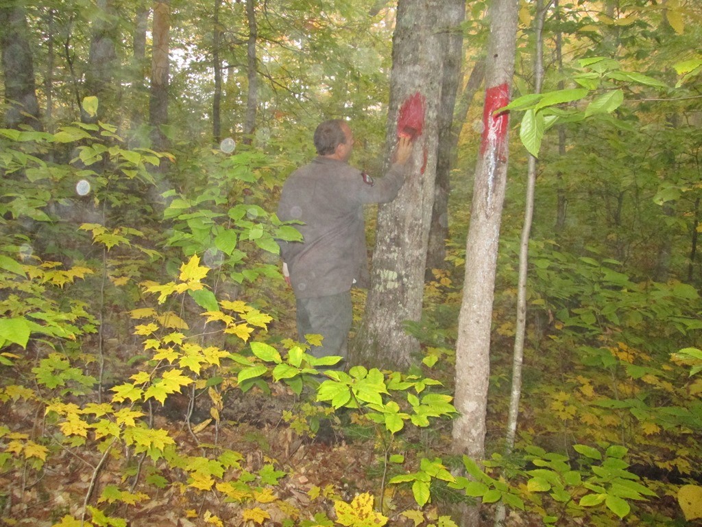 Marking the boundary line along wildlife managment areas provides benefits to both users and abutting landowners.[/caption]
The Delano Wildlife Management Area (WMA) is located about 4 miles north of the town of Monson along the eastern side of Routes 6 and 15. This 589 acre WMA wraps around Spectacle Pond, which is the only roadside pond visible between Monson and Greenville (see Map 41 of The Maine Atlas and Gazetteer, E3).
One responsibility that we have as a landowner is to ensure that the bounds of the WMA are well-marked so that it is easy for both the public (who may be using the WMA for sporting activities) and abutting landowners (who may have a different management plan than we do) to discern one piece of property from another. It is standard practice to remove the limbs and ground vegetation where the line lies (also known as brushing) so that there is a clear line of vision along the boundary. This is usually followed up by “spotting”, or cutting a small area from the bark, trees that lie along the line, or close to the line. These spots are then painted a chosen color (bright red, in our case) that is easy to see in all seasons.
Corners of the boundary are usually marked with a wooden post or rebar stake or something obvious that can be painted and easy to locate in the future. Trees close to the corner are usually spotted 3 times (also known as witness trees) in the event that the corner marker becomes missing. Spots on boundary or witness trees are located high enough on the tree so that they are still visible even in winters when snowfall totals are very high. Now that we are near the completion of this project, we expect it to last at least 20 years before we have to redefine the boundary again.
Marking the boundary line along wildlife managment areas provides benefits to both users and abutting landowners.[/caption]
The Delano Wildlife Management Area (WMA) is located about 4 miles north of the town of Monson along the eastern side of Routes 6 and 15. This 589 acre WMA wraps around Spectacle Pond, which is the only roadside pond visible between Monson and Greenville (see Map 41 of The Maine Atlas and Gazetteer, E3).
One responsibility that we have as a landowner is to ensure that the bounds of the WMA are well-marked so that it is easy for both the public (who may be using the WMA for sporting activities) and abutting landowners (who may have a different management plan than we do) to discern one piece of property from another. It is standard practice to remove the limbs and ground vegetation where the line lies (also known as brushing) so that there is a clear line of vision along the boundary. This is usually followed up by “spotting”, or cutting a small area from the bark, trees that lie along the line, or close to the line. These spots are then painted a chosen color (bright red, in our case) that is easy to see in all seasons.
Corners of the boundary are usually marked with a wooden post or rebar stake or something obvious that can be painted and easy to locate in the future. Trees close to the corner are usually spotted 3 times (also known as witness trees) in the event that the corner marker becomes missing. Spots on boundary or witness trees are located high enough on the tree so that they are still visible even in winters when snowfall totals are very high. Now that we are near the completion of this project, we expect it to last at least 20 years before we have to redefine the boundary again.
 Marking the boundary line along wildlife managment areas provides benefits to both users and abutting landowners.[/caption]
The Delano Wildlife Management Area (WMA) is located about 4 miles north of the town of Monson along the eastern side of Routes 6 and 15. This 589 acre WMA wraps around Spectacle Pond, which is the only roadside pond visible between Monson and Greenville (see Map 41 of The Maine Atlas and Gazetteer, E3).
One responsibility that we have as a landowner is to ensure that the bounds of the WMA are well-marked so that it is easy for both the public (who may be using the WMA for sporting activities) and abutting landowners (who may have a different management plan than we do) to discern one piece of property from another. It is standard practice to remove the limbs and ground vegetation where the line lies (also known as brushing) so that there is a clear line of vision along the boundary. This is usually followed up by “spotting”, or cutting a small area from the bark, trees that lie along the line, or close to the line. These spots are then painted a chosen color (bright red, in our case) that is easy to see in all seasons.
Corners of the boundary are usually marked with a wooden post or rebar stake or something obvious that can be painted and easy to locate in the future. Trees close to the corner are usually spotted 3 times (also known as witness trees) in the event that the corner marker becomes missing. Spots on boundary or witness trees are located high enough on the tree so that they are still visible even in winters when snowfall totals are very high. Now that we are near the completion of this project, we expect it to last at least 20 years before we have to redefine the boundary again.
Marking the boundary line along wildlife managment areas provides benefits to both users and abutting landowners.[/caption]
The Delano Wildlife Management Area (WMA) is located about 4 miles north of the town of Monson along the eastern side of Routes 6 and 15. This 589 acre WMA wraps around Spectacle Pond, which is the only roadside pond visible between Monson and Greenville (see Map 41 of The Maine Atlas and Gazetteer, E3).
One responsibility that we have as a landowner is to ensure that the bounds of the WMA are well-marked so that it is easy for both the public (who may be using the WMA for sporting activities) and abutting landowners (who may have a different management plan than we do) to discern one piece of property from another. It is standard practice to remove the limbs and ground vegetation where the line lies (also known as brushing) so that there is a clear line of vision along the boundary. This is usually followed up by “spotting”, or cutting a small area from the bark, trees that lie along the line, or close to the line. These spots are then painted a chosen color (bright red, in our case) that is easy to see in all seasons.
Corners of the boundary are usually marked with a wooden post or rebar stake or something obvious that can be painted and easy to locate in the future. Trees close to the corner are usually spotted 3 times (also known as witness trees) in the event that the corner marker becomes missing. Spots on boundary or witness trees are located high enough on the tree so that they are still visible even in winters when snowfall totals are very high. Now that we are near the completion of this project, we expect it to last at least 20 years before we have to redefine the boundary again.Categories