July 1, 2015 at 4:52 pm
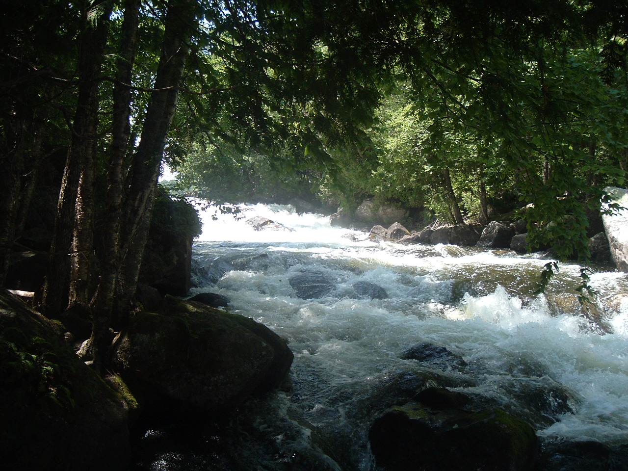
[caption id="attachment_807" align="alignright" width="329"] Mud Lake Falls is a quarter-mile of quickly dropping rapids.[/caption]
The Booming Ground Wildlife Management Area is located in the northeastern part of Forest City Township, Washington County, Maine, and is composed primarily of a peninsula formed by the dammed waters of the St. Croix River.
The WMA is a 650-acre property, made up of two parcels. One parcel is a 500-acre peninsula bounded on the east by Spednic Lake and on the west by Mud Lake. A second parcel is 150-acres, located on the south shore of Mud Lake, to the south of the peninsular parcel. The WMA is accessed by a lumber road off the Forest City Road as you enter the village of Forest City.
[caption id="attachment_804" align="alignleft" width="270"]
Mud Lake Falls is a quarter-mile of quickly dropping rapids.[/caption]
The Booming Ground Wildlife Management Area is located in the northeastern part of Forest City Township, Washington County, Maine, and is composed primarily of a peninsula formed by the dammed waters of the St. Croix River.
The WMA is a 650-acre property, made up of two parcels. One parcel is a 500-acre peninsula bounded on the east by Spednic Lake and on the west by Mud Lake. A second parcel is 150-acres, located on the south shore of Mud Lake, to the south of the peninsular parcel. The WMA is accessed by a lumber road off the Forest City Road as you enter the village of Forest City.
[caption id="attachment_804" align="alignleft" width="270"]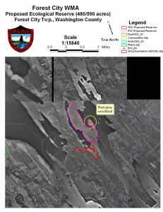 Located on the eastern edge of Maine in Forest City, Booming Ground WMA is a peninsula[/caption]
The WMA is largely mature conifer forest. Stands of hemlock, red spruce, white pine, and some cedar mixed with yellow birch and other tolerant hardwoods dominate the property. There are old stumps present, and while the forest in the WMA may not accurately be described as old growth, much of it is thought to be well over a hundred years old and fits the class of late successional. Mud Lake Falls, a waterfall and ¼-mile of class II rapids on the St. Croix River, is located at the northern tip of the peninsula.
Archaeological surveys performed in the area have discovered the existence of two sites having historical significance. One is a small camp or temporary habitation site adjacent to Mud Falls on the American side. Another is a canoe carry trail combined with an additional campsite. The trail, known as Hawthorne Carry, transects the peninsula in the area referred to as the Booming Ground. Artifacts from prehistoric periods have been found at these sites and dated by archaeologists. The campsite associated with the carry trail is on the east side near the shore of Spednic Lake. The Hawthorne Carry site is considered to be of special interest as an excellent survival of a prehistoric Native American carry trail.
[caption id="attachment_808" align="alignright" width="300"]
Located on the eastern edge of Maine in Forest City, Booming Ground WMA is a peninsula[/caption]
The WMA is largely mature conifer forest. Stands of hemlock, red spruce, white pine, and some cedar mixed with yellow birch and other tolerant hardwoods dominate the property. There are old stumps present, and while the forest in the WMA may not accurately be described as old growth, much of it is thought to be well over a hundred years old and fits the class of late successional. Mud Lake Falls, a waterfall and ¼-mile of class II rapids on the St. Croix River, is located at the northern tip of the peninsula.
Archaeological surveys performed in the area have discovered the existence of two sites having historical significance. One is a small camp or temporary habitation site adjacent to Mud Falls on the American side. Another is a canoe carry trail combined with an additional campsite. The trail, known as Hawthorne Carry, transects the peninsula in the area referred to as the Booming Ground. Artifacts from prehistoric periods have been found at these sites and dated by archaeologists. The campsite associated with the carry trail is on the east side near the shore of Spednic Lake. The Hawthorne Carry site is considered to be of special interest as an excellent survival of a prehistoric Native American carry trail.
[caption id="attachment_808" align="alignright" width="300"]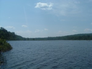 Mud Lake and neighboring Spednic Lake is known for its smallmouth bass fishery. A picnic spot with a fire ring is quite popular.[/caption]
The only development on the WMA is a lunch site with picnic table and fire ring near the shore of Mud Pond. The site is used and maintained by fishing guides from Forest City.
Mud and Spednic Lakes, as formed by the dammed waters of the St. Croix River, hold an abundance of smallmouth bass. This is an important recreational fishery surrounding the wildlife management area.
[caption id="attachment_802" align="alignleft" width="300"]
Mud Lake and neighboring Spednic Lake is known for its smallmouth bass fishery. A picnic spot with a fire ring is quite popular.[/caption]
The only development on the WMA is a lunch site with picnic table and fire ring near the shore of Mud Pond. The site is used and maintained by fishing guides from Forest City.
Mud and Spednic Lakes, as formed by the dammed waters of the St. Croix River, hold an abundance of smallmouth bass. This is an important recreational fishery surrounding the wildlife management area.
[caption id="attachment_802" align="alignleft" width="300"]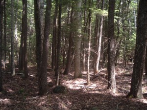 The peninsula is forested, and is comprised of a mix of both hardwoods and softwoods.[/caption]
 Mud Lake Falls is a quarter-mile of quickly dropping rapids.[/caption]
The Booming Ground Wildlife Management Area is located in the northeastern part of Forest City Township, Washington County, Maine, and is composed primarily of a peninsula formed by the dammed waters of the St. Croix River.
The WMA is a 650-acre property, made up of two parcels. One parcel is a 500-acre peninsula bounded on the east by Spednic Lake and on the west by Mud Lake. A second parcel is 150-acres, located on the south shore of Mud Lake, to the south of the peninsular parcel. The WMA is accessed by a lumber road off the Forest City Road as you enter the village of Forest City.
[caption id="attachment_804" align="alignleft" width="270"]
Mud Lake Falls is a quarter-mile of quickly dropping rapids.[/caption]
The Booming Ground Wildlife Management Area is located in the northeastern part of Forest City Township, Washington County, Maine, and is composed primarily of a peninsula formed by the dammed waters of the St. Croix River.
The WMA is a 650-acre property, made up of two parcels. One parcel is a 500-acre peninsula bounded on the east by Spednic Lake and on the west by Mud Lake. A second parcel is 150-acres, located on the south shore of Mud Lake, to the south of the peninsular parcel. The WMA is accessed by a lumber road off the Forest City Road as you enter the village of Forest City.
[caption id="attachment_804" align="alignleft" width="270"]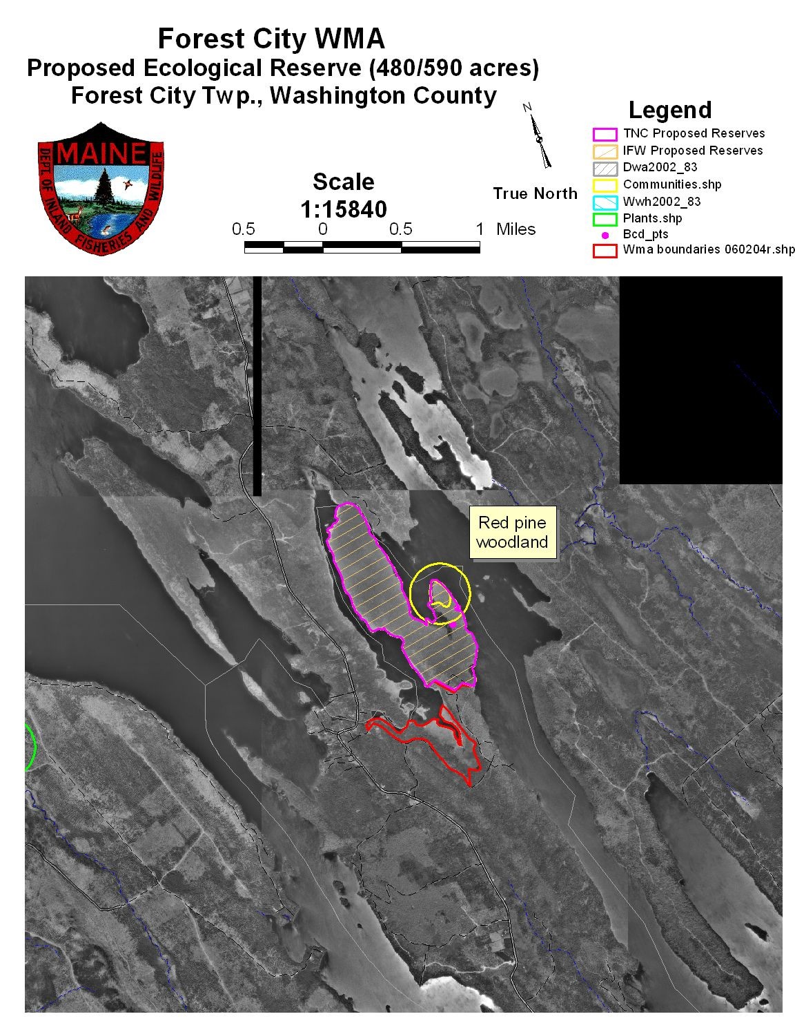 Located on the eastern edge of Maine in Forest City, Booming Ground WMA is a peninsula[/caption]
The WMA is largely mature conifer forest. Stands of hemlock, red spruce, white pine, and some cedar mixed with yellow birch and other tolerant hardwoods dominate the property. There are old stumps present, and while the forest in the WMA may not accurately be described as old growth, much of it is thought to be well over a hundred years old and fits the class of late successional. Mud Lake Falls, a waterfall and ¼-mile of class II rapids on the St. Croix River, is located at the northern tip of the peninsula.
Archaeological surveys performed in the area have discovered the existence of two sites having historical significance. One is a small camp or temporary habitation site adjacent to Mud Falls on the American side. Another is a canoe carry trail combined with an additional campsite. The trail, known as Hawthorne Carry, transects the peninsula in the area referred to as the Booming Ground. Artifacts from prehistoric periods have been found at these sites and dated by archaeologists. The campsite associated with the carry trail is on the east side near the shore of Spednic Lake. The Hawthorne Carry site is considered to be of special interest as an excellent survival of a prehistoric Native American carry trail.
[caption id="attachment_808" align="alignright" width="300"]
Located on the eastern edge of Maine in Forest City, Booming Ground WMA is a peninsula[/caption]
The WMA is largely mature conifer forest. Stands of hemlock, red spruce, white pine, and some cedar mixed with yellow birch and other tolerant hardwoods dominate the property. There are old stumps present, and while the forest in the WMA may not accurately be described as old growth, much of it is thought to be well over a hundred years old and fits the class of late successional. Mud Lake Falls, a waterfall and ¼-mile of class II rapids on the St. Croix River, is located at the northern tip of the peninsula.
Archaeological surveys performed in the area have discovered the existence of two sites having historical significance. One is a small camp or temporary habitation site adjacent to Mud Falls on the American side. Another is a canoe carry trail combined with an additional campsite. The trail, known as Hawthorne Carry, transects the peninsula in the area referred to as the Booming Ground. Artifacts from prehistoric periods have been found at these sites and dated by archaeologists. The campsite associated with the carry trail is on the east side near the shore of Spednic Lake. The Hawthorne Carry site is considered to be of special interest as an excellent survival of a prehistoric Native American carry trail.
[caption id="attachment_808" align="alignright" width="300"]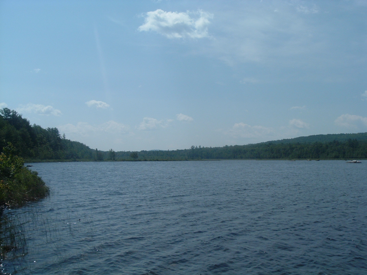 Mud Lake and neighboring Spednic Lake is known for its smallmouth bass fishery. A picnic spot with a fire ring is quite popular.[/caption]
The only development on the WMA is a lunch site with picnic table and fire ring near the shore of Mud Pond. The site is used and maintained by fishing guides from Forest City.
Mud and Spednic Lakes, as formed by the dammed waters of the St. Croix River, hold an abundance of smallmouth bass. This is an important recreational fishery surrounding the wildlife management area.
[caption id="attachment_802" align="alignleft" width="300"]
Mud Lake and neighboring Spednic Lake is known for its smallmouth bass fishery. A picnic spot with a fire ring is quite popular.[/caption]
The only development on the WMA is a lunch site with picnic table and fire ring near the shore of Mud Pond. The site is used and maintained by fishing guides from Forest City.
Mud and Spednic Lakes, as formed by the dammed waters of the St. Croix River, hold an abundance of smallmouth bass. This is an important recreational fishery surrounding the wildlife management area.
[caption id="attachment_802" align="alignleft" width="300"] The peninsula is forested, and is comprised of a mix of both hardwoods and softwoods.[/caption]
Categories