Adapting to climate change
MaineDOT is experiencing the effects of climate change first-hand. In the last five years, a number of large storm events resulted in infrastructure failure, causing roads to be impassible, extended detours, and millions of dollars in damage. As noted in the Maine Climate Council’s Vulnerability Mapping Report (PDF), many culverts across the state have a greater than 66% chance of overtopping within the next 30 years (75-year or greater recurrence interval peak flows). Additionally, along the coast, the Maine Climate Council recommends the state commit to manage 1.5 feet of relative sea level rise by 2050, and 3.9 feet of sea level rise by 2100. The data and science to support this recommendation are included in the Scientific Assessment of Climate Change and Its Effects in Maine (PDF), which is also available on the Maine Climate Council Website. To lower the risk of future damage to infrastructure, MaineDOT has taken a number of steps to reduce vulnerability to climate change for transportation assets and other infrastructure.
General Information
- MaineDOT Design Guidance
MaineDOT has updated design standards for culverts and bridges to take climate impacts into account. When designing transportation infrastructure, that could be under the influence of sea level rise, the target is to account for 4 feet of sea level rise at 2100. The change was based on the National Oceanic and Atmospheric Administration’s (NOAA) historical data for the Maine coast and a range of predictions for future sea level rise and is consistent with the current recommendations of the Maine Climate Council. Additionally, MaineDOT culverts on the inland side are now designed for 100-year flow rates; prior design guidance was for the 25-year storm event.
- MaineDOT At-Risk Coastal Infrastructure Projects
MaineDOT has identified six segments of road as particularly vulnerable to flooding during storm events and/or sea level rise:
- US 1, Scarborough
- Route 9, Scarborough
- Route 15, Deer Isle
- Route 127, Arrowsic
- Route 209, Phippsburg
- Route 1A, Frankfort
MaineDOT has started preliminary engineering on these six at-risk coastal infrastructure projects that currently experience flooding. Construction cost estimates have been completed on 5 of the 6 projects, with estimates ranging from $3 to $30 million dollars. Further, MaineDOT has conducted a feasibility study on the little causeway and the main causeway in Deer Isle. The purpose of the study was to evaluate several alternatives to improve transportation reliability and resiliency by addressing impacts from sea level rise, severe storm events, and erosion while maintaining connectivity during construction. At the Scarborough Route 1 project, MaineDOT has modeled various currents and flows to establish the size of the opening and height of the road surface, as well as further preliminary design on the entire roadway. Preliminary design has been completed for Arrowsic and Phippsburg.

Click to Enlarge - Maine Coastal Flood Risk Model
MaineDOT is working in collaboration with other state agencies, and the Woods Hole Group, to develop a high-resolution, dynamic, and probabilistic model of current and future flood risk along the Maine coast. The Maine Coastal Flood Risk Model will integrate the Maine-based sea level rise projections in existing law with data about coastal storm events.
The Model aims to provide information to public and private landowners to assist them in making more informed decisions about activities in the coastal environment. Products from the Model will be made available across state governments as well as in communities and regional planning organizations across the state. Model output for part of the coast is expected to be available in June 2026 and for remaining areas by the end of 2026.
Grant Programs
- Maine Infrastructure Adaptation Fund (MIAF)
MaineDOT administers the Maine Infrastructure Adaptation Fund (MIAF). The purpose of this funding is for municipal, tribal, and infrastructure districts to adapt their critical infrastructure to reduce vulnerability to climate change.
Funding
MIAF was a recommendation within Maine Won't Wait, the state's four-year climate action plan. In December 2021, Governor Mills announced the creation of MIAF. Since the creation of the fund, MaineDOT has held three rounds of funding, with a fourth opportunity coming in March 2026, through the National Oceanic and Atmospheric Administration (NOAA) Climate Resilience Regional Challenge. There are no designated funding sources for MIAF, therefore eligible projects, maximum grant awards, etc., can change depending on the funding source. However, the intent of the program, climate resiliency, has stayed the same.
The grant funding cap depends on the funding source/round but has ranged from $50,000 - $75,000 for scoping and design projects and between $125,000 - $4,000,000 for construction projects. MIAF typically requires a 5% local match share (cash or in-kind) that is raised or appropriated by the entity applying. This program is reimbursement only.
Eligible projects
Typically, this program will fund 1) scoping and design 2) construction projects or 3) a combination of scoping, design and construction not to exceed the maximum grant fund amount. Examples of projects funded through this program are:
- Stormwater
- Wastewater
- Drinking water upgrades to meet resilience of the system
- Transportation resilience projects such as raising roads or moving roads inland due to flooding
- Shoreline stabilization
Project eligibility depends on the funding source and will be defined in each specific Request for Applications (RFA).
Timeline of funding opportunity
The Grant Tentative Timeline below provides a conservative schedule. This timeline accounts for possible delays beyond MaineDOT's control, such as federal government shutdown or delays in the environmental compliance review.
- MaineDOT posted the 2026 MIAF notice on December 31, 2025, to inform individuals about the funding opportunity and encourage them to start considering potential projects.
- The Request For Applications (RFA) went live on March 30, 2026.
- On April 29, 2026, MaineDOT held an open-hour MIAF Workshop Session.
- The RFA stayed open for six weeks and closed on May 11, 2026, at 11:59pm EST.
- The interagency review team will be scoring applications over the new few months (60 - 120 days).
- Applicants should expect to receive conditional award and non-award letters around October 2026.
- Conditional Grantees undergo NOAA's environmental compliance process. This step could take approximately 90 to 180 days.
- Grant Agreements will be issued sometime around the end of March 2027. With the grant agreement recipients will receive details of all requirements, including reporting, project milestones, and reimbursement requirements.
- Grantee Orientation Meeting will be held in April or May of 2027.
- Projects have until 9/30/2029 to be completed. No extensions are allowed.

Click to enlarge For more information, please review the Frequently Asked Questions document.
Contact
If you have any questions, please email the Adaptation inbox
- Maine Public Working Waterfront Infrastructure Fund
MaineDOT and other state partners administer the Maine Public Working Waterfront Infrastructure Fund. This program is for Municipalities or Tribal Governments to adapt existing public working waterfront infrastructure to reduce vulnerability to climate change, sea level rise, coastal flooding, and other impacts.
Funding
The Maine Public Working Waterfront Infrastructure Fund is a new funding opportunity made possible through the National Oceanic and Atmospheric Administration (NOAA) Climate Resilience Regional Challenge, as well as other federal funding. This program differs from the Working Waterfront Resilience Grant Program that was funded through state funding, authorized through the supplemental budget in May 2024.
This program will provide grants for 1) scoping and design 2) construction projects at existing public working waterfronts or 3) a combination of scoping, design, and construction. Applicants may request up to $75,000 for scoping and design and up to $2,000,000 for construction or a combination of scoping, design, and construction not to exceed $2,000,000. This program requires a 5% local match share (cash or in-kind) of the total project costs (the project phase that is being applied for). The local match amount must be raised or appropriated by the entity applying. This grant program is reimbursement only.
Eligible projects
Eligible properties include Municipal or Tribally owned existing public working waterfronts abutting tidal waters or located in the intertidal zone that provide access to or support commercial fishing, aquaculture, or other commercial marine activities. This could include boat launching, water access paths, gear loading/unloading space, or equipment, among other things. Projects could include elevating, strengthening or relocating existing infrastructure, or other activities that will make public working waterfront infrastructure more accessible to commercial and recreational users and functional in future conditions. Properties do not have to be exclusively for commercial use; however, the use of the grant funds must demonstrate a benefit to commercial fishing and aquaculture industries in Maine.
Timeline of funding opportunity
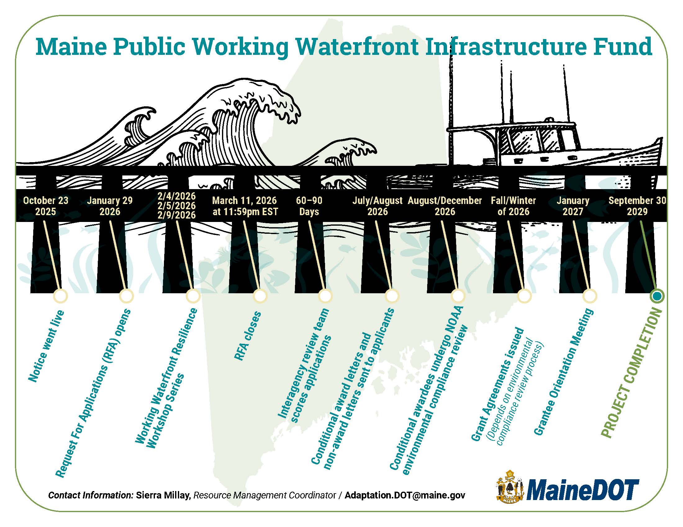
MaineDOT posted a notice on October 23, 2025, about the upcoming funding opportunity. The Request For Applications (RFA) went live on January 29, 2026. MaineDOT presented at the Working Waterfront Resilience Workshop Series on February 4, 5, and 9. The RFA closed on March 11, 2026, at 11:59 EST. The inter-agency review team will be scoring applications over the next few months (60 - 90 days). Applicants should expect to receive conditional award and non-award letters in July or August. Conditional awardees will then undergo environmental compliance review by NOAA between August - December. Once environmental compliance review has been completed, grant agreements will be issued. Grantee Orientation Meeting will be held in January 2027. All projects must be completed by September 30, 2029. For more information, please review the Frequently Asked Questions document.
Contact
If you have any questions, please email Adaptation.DOT@maine.gov
Click to enlarge - Municipal Stream Crossing (MSC) Program
MaineDOT administers the Municipal Stream Crossing Program. The intent of the program is to replace municipal stream crossings (e.g. culverts, minor spans, bridges) under local government roads to improve fish and wildlife habitat and community safety.
Funding
The Maine Department of Environmental Protection (MaineDEP) had administered the program from 2015 - 2022. MaineDOT acquired the program from MaineDEP, in 2023. MaineDOT held one round of funding in the beginning of 2024. When funding is allocated to the program, the Request for Applications will be posted on this webpage. See future funding opportunities for more detail.
In the last opportunity, the maximum grant funding amount was $200,000. The MSC program requires a $5,000 local match share (cash or in-kind) that is raised or appropriated by the municipality applying. This program is reimbursement only.
Eligible projects
Eligible projects are stream crossings (e.g. culverts, minor spans, bridges) that carry a stream under a town-owned roadway, not a state (including state-aid) or private road. Use MaineDOT Public Map Viewer to ensure the structure is located on a municipal owned facility (town way). Municipalities can request funding for projects that include design and construction, as long as the project results in completed construction. All projects must end in completed construction.
Project requirements
- Replacement structures need to meet 1.2x the stream's bankfull width and MaineDOT's 100-year flood standard
- Design plans will need to be shared and reviewed by MaineDOT's Bridge Maintenance Office for structures that span 10 feet or greater. Please review the 2020 Fact Sheet listed under helpful resources
- All final design plans must be stamped by a Professional Engineer (PE) licensed in Maine
- Any required permits, such as Army Corps of Engineers permit will need to be shared with MaineDOT prior to construction
- After project completion, the awarded Municipality must submit a written certification stamped by a PE licensed in Maine, stating that the project is complete and was constructed as designed
- The awarded applicant is required to complete an Annual and Final Report Form that will be provided to you
Helpful resources
- 2020 Fact Sheet on Current Bridge Policies and Laws
- MaineDOT's Bridge Design Guidance
- Stream Smart Field Work Video
- Maine Stream Habitat Viewer
- StreamStats
- Beginning with Habitat Map Viewer
Future funding opportunities
There are no future funding opportunities at this time. If available, future funding opportunities will be posted on this webpage.
Contact
If you have any questions, please email the Municipal Stream Crossing inbox