Home → Water Quality → Monitoring & Reporting → Biomonitoring → Sampling & Analysis → River & Stream Algae
 Algae Sampling in Rivers & Streams
Site locations & rationale
The Biological Monitoring Program has been sampling algae from rivers and streams throughout the State of Maine since 1999. Sampling is usually performed between mid-June and the end of July. This time frame ensures that all sites are receiving approximately the same level of daily exposure to sunlight when they are sampled. Sampling during this time period also ensures that river and stream flow is no longer directly influenced by spring snow melt. Sampling is usually conducted in areas of moderate flow with low density canopy cover.
Sampling methods
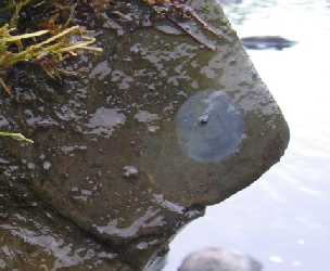
Rock or log scrapings This method of sampling focuses on epilithic algae, the type of algae that live on rocks, although logs and other large woody debris can also be sampled when rocks are not available as habitat at a site. Rocks are sampled along transects at the sampling site. A cobble-size rock is collected from the beginning, middle, and end of each transect. A circular rubber sampling device is placed on the rock to standardize the surface area of the sample. Algae are removed from the rock within the designated area (see the picture above). Algae from all rocks are pooled into one sample representing the entire site. A similar approach is used on logs when rocks are not available.
Viewing bucket survey This method provides an estimate of the amount and types of periphyton cover existing on the stream bottom at a given site. A viewing bucket with a clear bottom is used to record the length of filamentous algae and the thickness of periphyton mats. This process is repeated at multiple locations within a given site. Minimally disturbed streams usually have very little algal growth with thin, transparent layers on rocks and isolated patches of filamentous algae. Streams and rivers enriched with nutrients often have thick mats of algae smothering rocks and/or long strands of filamentous algae.
Data analysis
The algae in a rock or log scraping sample are identified to the lowest practical taxonomic level. Diatoms are typically identified to species or subspecies level while green algae, red algae, cyanobacteria, and other algae are usually identified to genus or species level. The data are reported with cell densities (cells per unit area sampled) and cell biovolumes (micrometers per unit area sampled). The Biological Monitoring Program uses a statistical model based on algal metrics calculated from results of rock or log scraping samples to predict the probability of a waterbody attaining aquatic life criteria for Class AA/A, B or C, or of not attaining criteria for any water quality class (NA, non-attainment).
Results of viewing bucket surveys are not used to determine attainment of aquatic life criteria, but the percent cover of nuisance algae calculated from the surveys is used as a biological indicator for phosphorus criteria described in Chapter 583 rules (Nutrient Criteria for Class AA, A, B, and C Fresh Surface Waters).
For more information on how the Biological Monitoring Program samples algae from rivers and streams, please visit our Materials Page.