Home → Air Quality → Monitoring and Reporting → Monitoring Sites Map
Maine's Air Monitoring Sites
Monitor Map Legend Explained
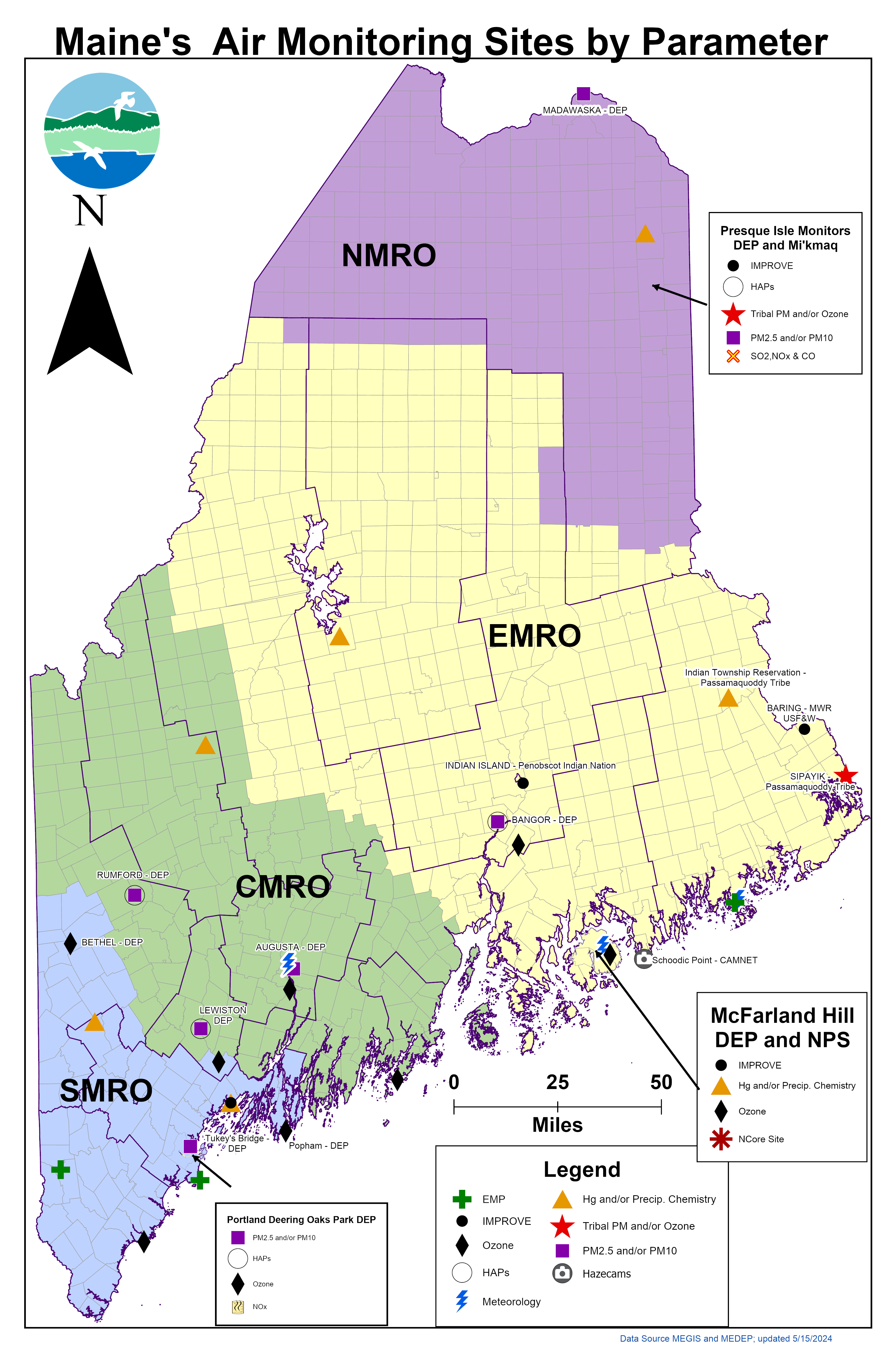
Monitoring Organizations – While Maine DEP conducts the bulk of the air quality monitoring in the state, air quality data is collected by other organizations at multiple sites (numbered on map) around the state. These other organizations include, the Penobscot Nation (sites 1 and 2), the Passamaquoddy Tribe of Sipayik (3), Mi’kmaq Nation (4), National Park Service (5 and 6), the US FWS (7) and Passamaquoddy Tribe of Indian Township (8).
Regional Offices – Maine is split into four regions, with a DEP office in each region responsible for the sites in that region. Northern Maine Regional Office (NMRO) in green, Eastern Maine Regional Office (EMRO) in purple, Central Maine Regional Office (CMRO) in yellow, and Southern Maine Regional Office (SMRO) in blue.
Monitored Pollutants – The DEP and other organizations in the state monitor a large array of air quality pollutants (e.g., ozone, and particulate matter), along with supporting parameters (e.g., wind speed and direction) or research and trends parameters (e.g., particulate speciation or precipitation chemistry). Ozone, particulate matter (PM), and hazardous air pollutants (HAPs) are the dominant air quality pollutants of focus in the state, with at least one being collected at nearly every site in the state.
Map symbol descriptions - The symbols used in the figure have five elements, indicated by either being filled (black) or empty (light grey). The first four elements indicate the presence of pollutant monitoring being conducted at that site. Each of these four elements are one quadrant of a complete circle, with the top left for ozone, top right for continuous PM, and bottom left for hazardous air pollutants. The bottom right quadrant is for all other pollutants and parameters collected and measured. The final element is a ring on the outer edge of the circle. This ring is used where the site density is too high, and a single symbol is being used to indicate multiple sites. A quadrant is filled if any site represented by the symbol has the appropriate pollutant.
There are 22 single site symbols in the figure and five multiple site symbols. Multiple site symbols are located in Portland and South Portland (9 sites), Augusta (3 sites), Bar Harbor (2 sites), Old Town/ Indian Island/Alton (4 sites) and Presque Isle (3 sites).
Maine DEP's Bureau of Air Quality produces an annual air monitoring plan every year. This plan contains a more in-depth description of the monitoring networks, monitoring site types, objectives, and monitored pollutants. The current plan can be found on the Air Monitoring and Reporting page.