Home → Air Quality → Programs→ Meteorology → Wind Information
Wind Information
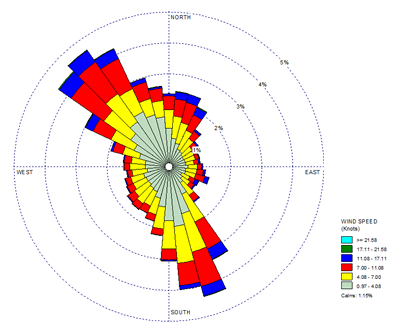
All meteorologists, but especially Air Quality Meteorologists, are interested in wind direction information at a given location. One tool that meteorologists use to provide a visual depiction of wind direction frequency at a given location is called a wind rose because it displays wind information and sometimes it looks like a rose.
Windroses from Maine DEP:
- Display the direction the wind came from.
- Present the data for 36 directions in 10 degree sectors.
- Depict 5 years of data. A database of 5 years or longer will average a wide range of wind conditions and is a common timeframe for air quality analysis. While the wind roses are not all from the same 5 year time period, each should be representative of winds at that location.
- Are site specific. Topography and land / sea breezes at coastal sites all impact winds near the surface. There may be a great difference between winds in a river valley and winds just a few miles away in open terrain or high elevation.

Maine DEP maintains a number of monitoring stations around the state collecting air pollution data and some also collect meteorological data (DEP MET), mainly wind direction and speed. At DEP MET sites, wind data is collected continuously and a minute average is tabulated. An hourly average is calculated from that hour's 60 one-minute averages*.
Please contact us to request one or more wind roses for sites shown on the map.
Online tools to create a wind rose
Wind data is collected at many different sites around the state and country. Sites are grouped and organized into networks such as the Automated Surface Observing Systems (ASOS) installed at airports in the United States. There are several online tools that can be used to create wind roses. Before using an online tool, please remember that unless the site is at or adjacent to the location you have in mind the resulting wind rose may not truly represent the winds for your location of interest.
- Wind Roses from airports around the world - Graphics or Raw Data Tables This tool lists several networks available in Maine, but ASOS is most likely to have sufficient data to generate a wind rose. Explore the site to see if you can find data for your area of interest.
- Northeast Climate Center For this tool you either need to know the station ID or the city & state or the zip code.
- Iowa State This link brings you to Maine ASOS sites and from here you canselect from a number of automated weather stations to obtain weather data.
* Important Note About Wind Data Collection Methods: The way the National Weather Service (NWS) reports winds is different from the way DEP reports winds. Wind direction information on NWS sites is a snapshot' of a moment in time rather than an hourly average. You can view the NWS current winds by following these steps:
- Go to either Gray NWS or Caribou NWS depending on which part of the state concerns you.
- Click on the map for the location you are interested in.
- The resulting page displays the forecast for that location. On the right, part-way down the page, you will see the most current hour of weather data from the nearest NWS monitor to that location.
- Links to view data from other nearby NWS monitors or a 3 day history of hourly weather from that monitor are displayed under the current weather data.