Home → Air Quality → Meteorology Home → Permit Air Quality Modeling Guidelines → Meteorological Data
Meteorological Data For Air Quality Modeling
An appropriate meteorological database must be used as input for sequential dispersion modeling. Before beginning to process any meteorological data, it is very important to determine that the meteorological data is representative. Representative is defined as the extent to which a set of measurements taken at the collection site (met tower) spatially and temporally reflects the actual conditions at the application site (source/facility). The collected meteorological data should closely mimic the conditions affecting the transport and dispersion of pollutants in the area of interest as determined by the locations of the sources/receptors being modeled. Representativeness of meteorological data depends on the following factors:
• Character and complexity of the terrain in the source surroundings and between the source and the meteorological monitoring or observing site;
• Proximity of the meteorological monitoring site to the source;
• Instrumentation and exposure of the meteorological monitoring site; and
• Quality, completeness, and period of record of the meteorological data.
The acceptability of a meteorological database, expressed in terms of percentage recovery and duration of record, must be in the context of adequacy and suitability for modeling in accordance with the document Meteorological Monitoring Guidance for Regulatory Modeling Applications (EPA, 2000) and all applicable MEDEP-BAQ/EPA guidelines.
On-Site/Off-Site Meteorological Data
Meteorological data plays a very important role in estimating modeled concentrations of the various pollutants. The collection and processing of the data for model input should be done with great care, to insure that the accuracy and integrity of the data is maximized. Meteorological data is traditionally broken into 2 categories: "on-site" and "off-site":
On-Site Data
On-site meteorological data is generally defined as data that is collected within close proximity to the modeled source and is truly representative of localized conditions near the stack. While EPA no longer interprets "on-site" to mean "data that has been collected on-property", MEDEP-BAQ does require strong justification for a source located somewhat further away from the collection site for the meteorological data to be considered "on-site".
The representativeness of "on-site" data for use with "off-site" sources depends on the distance from the source and the complexity of terrain both immediately surrounding the source and between the source and collection location. One may consider data as "on-site" if the terrain is generally simple around the source, at the collection site, and between the source and collection site. Conversely, data is not likely to be considered "on-site" where significant intervening terrain separates the source and collection location and/or where significant local circulation's (sea breeze, channeled flow, etc.) affect either the source or collection location, etc.Off-Site Data
Off-site meteorological data is defined as data that is generally representative of conditions at the modeled source, although localized variations are not likely to be captured in the data. MEDEP-BAQ does offer more flexibility for using meteorological data that was collected somewhat further removed from the stack.
If you have any questions regarding the appropriateness of particular dataset that you wish to use, you should consult with the project meteorologist for help prior to performing any modeling.
Period Of Record
As stated in the Guideline On Air Quality Models, the user should "acquire enough meteorological data to ensure worst-case meteorological conditions are adequately represented in the model results." Section 9.3.1.2 recommends using five years of "off-site" data or at least one year of "on-site" data. If more than one year of site-specific (i.e. "on-site") data is available, then all years, up to five years, shall be used.
To allow for the unexpected, such as a gap in data from a catastrophic incident or a persistent but subtle problem that evades detection, a five (5) year on-site meteorological database acceptable for modeling purposes need not be compiled from either five (5) consecutive years or sixty (60) consecutive months of data. If this is the case, then the applicant must write to the Department requesting an exemption from the consecutive five (5) year database requirement. Once a five (5)-year on-site database is developed, the database will be considered to remain climatologically valid and, hence, appropriate for regulatory purposes. If data requirements, source configurations or characteristics of the surrounding area change, the database may need to be updated after consultation with the Department. However, a requirement to collect a new database will neither preclude the applicant's ability to use the existing database in the interim data collection period nor require the applicant to redo any previously submitted analyses that used the original database.
Available Databases
MEDEP-BAQ has several five-year meteorological datasets available for use. While these meteorological datasets are typically AERMOD-ready, it may be necessary for the user to re-process the data through the most recent version of AERMET or AERSURFACE. Consult with the project meteorologist as to which of the following datasets will be best suited for you application:
AERMOD-READY PROCESSED DATA
1991-1996*
76
* AERMET dataset spans 6 year period, as raw met data was not processed using calendar years (i.e., January 1 - December 31)
DATA SOMEWHAT READY TO BE PROCESSED IN AERMET
Millinocket
Great Northern Paper (Katahdin Paper)
90
Auburn
Lewiston/Auburn Airport DEP
15
Westbrook
SAPPI Paper
100
RAW DATA OR DATA NOT YET PROCESSED
Madawaska
Fraser Paper
60
Data Collection
It is assumed that the data that you will be proposing for use in your modeling analysis will meet all of the requirements set forth by EPA (see EPA, 2000).
Database Preparation
Standard EPA pre-processing techniques should be used in preparing a meteorological database for air quality dispersion modeling, regardless of the model chosen.
When preparing a database for model use, only EPA-approved preprocessors (AERMET, etc.) are to be used. Meteorological preprocessors require many user-selected parameters, many which will require sound meteorological judgment and expertise. The modeling protocol should contain sufficient detail/justification to demonstrate to the project meteorologist that the meteorological data has been processed with a high degree of quality assurance, so that the integrity of the meteorological data can be maximized.
On-Site Data
Transport Wind Speed and Direction
Transport wind speed and direction are to be derived from data measured at or near stack top. For complex industrial sources with multiple stacks, stack top is generally taken as the height of the tallest stack.
AERMOD Stability Classes
AERMOD includes a continuous treatment for characterizing dispersion based on similarity theory, as compared to ISC's use of six P-G stability classes. The Monin-Obukhov length (L) is used as the primary parameter, and is computed by the AERMET meteorological preprocessor.
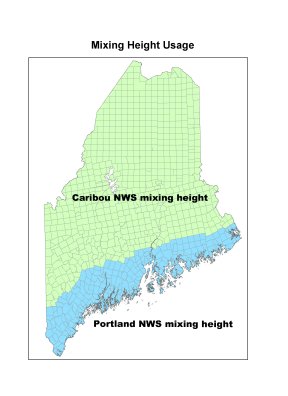
Mixing Height
Mixing heights are calculated using upper air data from radiosonde (weather balloon) ascents coupled with surface data. Upper air data are available for two sites in Maine: Portland and Caribou. Mixing heights for coastal and near coastal areas are best determined from surface and upper level data collected at Portland while mixing heights for inland areas are best determined from surface and upper level data collected at Caribou. Use the following figure to determine which upper air data should be used for the source being modeled.
Mixing heights should be calculated using surface data and upper air data from the same site. Mixing height data are available from the NCDC and SCRAM websites.
Off-Site Data
The most representative surface data for dispersion modeling would be collected on-site. Should on-site data be unavailable, meteorological data may be available from other sites (such as the National Weather Service (NWS), Federal Aviation Administration (FAA), military stations, universities, industry or from MEDEP-BAQ for selected regional representative sites within the State (e.g., Auburn, Augusta, Bangor, Presque Isle, Portland, etc.)).
Although MEDEP-BAQ will typically try to help you get the meteorological data that you need for your project, the applicant is ultimately responsible for obtaining representative data. The applicant is also responsible for processing any raw data obtained from MEDEP-BAQ and other off-site sources.
It is necessary to check with MEDEP-BAQ prior to modeling, to determine if your proposed meteorological data is the proper dataset to be using.
Missing Data
Substitutions for missing data are allowed, but may not exceed 10 percent of the hours (876 hours per year) in the database. Guidance on treatment of missing on-site meteorological data as well as treatment of calms can be found in the Guideline on Air Quality Models and the latest version of Meteorological Monitoring Guidance for Regulatory Modeling Applications. The same procedures for "on-site' data should be used for treatment of missing "off-site" data.
Before use in modeling, a preprocessed meteorological database should be examined by the applicant and MEDEP-BAQ to ensure that all values are reasonable and proper. The apparent correctness of the model meteorological database may be assessed via cumulative distributions of the model meteorological parameters along with extremes and means, median, or modal values, in addition to comparison of data to other neighboring collection sites.
Period Of Validity
Once a 5-year database is developed, the database will be considered to remain climatologically valid and, hence, appropriate for regulatory purposes. If data requirements, source configurations or characteristics of the surrounding area, or approved air quality models change, the database may need to be updated after consultation with MEDEP-BAQ. As new air quality models are approved by EPA, the data may need to be reprocessed for use. However, a requirement to collect a new database will neither preclude the applicant's ability to use the existing database in the interim data collection period nor require the applicant to redo any previously submitted analyses that used the original database.
Submittal Of Meteorological Data
MEDEP-BAQ requires that ALL meteorological input, output and diagnostic files used in refined modeling analyses (regardless of model) be formatted for use by computer software used by MEDEP-BAQ and submitted on compact discs. This includes all raw surface and upper air data as well as any utilities used to process the meteorological data for model use.