DACF Home → Bureaus & Programs → Maine Geological Survey → Maps, Publications and Online Data → Using Geologic Maps → Coastal Marine Geologic Environments Maps
Coastal Marine Geologic Environments Maps Description
What are coastal marine geologic environments?
Coastal marine geologic environments are located between the nearshore uplands and shallow subtidal depths approximately 25-30 feet below the low-tide mark. Supratidal, intertidal, and subtidal environments include features such as sand dunes, salt marshes, beaches, channels, and mud flats.
Coastal Marine Geologic Environments Maps
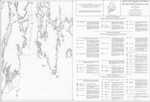
This black-and-white map series illustrates the size and location of marine geologic environments for the entire Maine coast. Fifty-five environments are distinguished with simple letter codes. Refer to the explanation for a description of the types of mapped environments.
Uses of coastal geologic environment information
These maps show regional characteristics of the Maine coast. They illustrate which areas are rocky, muddy, sandy, etc. along the shoreline between the high- and low-tide lines. These maps include sand and gravel beaches and dunes in areas of the state where MGS has not published detailed Coastal Sand Dune Geology Maps for use in the Department of Environmental Protection permitting process. These maps illustrate the location of salt marshes and other tidal wetlands for evaluation of coastal habitats, impact of dredging, and siting of coastal facilities. Alison Ward analyzed these maps for the Maine Department of Environmental Protection and results are summarized in a report entitled Maine's Coastal Wetlands (DEPLW1999-13). Additional description of map units is available in the (now out-of-print) 1983 State Planning Office publication The Geology of Maine's Coastline: a handbook for resource planners, developers, and managers. Copies of this publication are available at many Maine libraries. These maps do not provide an exact location of a tidal datum such as mean low water along the coast.
How to obtain or view these maps
Use the Maps and Publications Search to identify printed and online publications available from the Maine Geological Survey. You can search for maps and publications by geographic area or subject. Search results are linked to online publications. To order printed materials see the ordering instructions.
Last updated on June 12, 2018