DACF Home → Bureaus & Programs → Maine Geological Survey → Hazards → Earthquakes → Recent Maine Earthquakes → 12-27-01 Earthquake
December 27, 2001 Earthquake in Eastern Maine
Weston Observatory reports that a small earthquake occurred at 3:54:27 p.m. Eastern Standard Time on Thursday, December 27, 2001 northeast of Bangor in a sparsely populated part of eastern Maine.
The following parameters have been calculated for the earthquake (this is a preliminary determination):
| Preliminary magnitude | 2.8 |
| Preliminary location | 45 deg. 3 min. North latitude, 68 deg. 9 min. West longitude |
| Depth | 22 kilometers |
| This places the epicenter near the south end of Nicatous Lake in northern Hancock County. | |
Further Information:
The Maine Geological Survey received only two felt reports, from Greenfield and Burlington. This is not surprising given the earthquake's small magnitude and relatively great depth, and also considering the low population density of the region.
Canadian Seismic Network Hourly plot for 20:00 to 21:00 (UT) on December 27, 2001. The earthquake registered on several instruments between 20:50 and 21:00.
Phase Data Listing of Weston Observatory. This table lists information about the earthquake recorded at seismic stations around the region. It also gives statistics related to calculating the time, location, and magnitude of the earthquake.
Epicenter
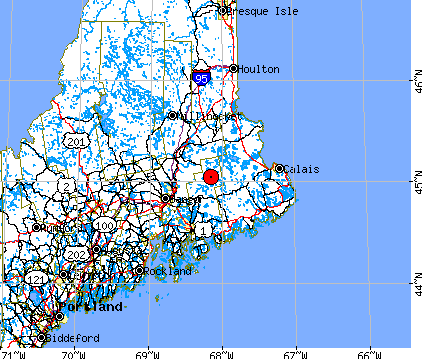
December 27, 2001 Maine, Approximately 56 km ENE of Bangor
| DATE | ORIGIN | LAT N | LONG W | DEPTH | MN | MC | ML GAP | RMS | ERH | ERZ Q |
| 11227 | 2054 | 28.92 | 45-2.51 | 68- 9.36 | 21.68 | 2.8 | 130 | 0.39 | 4.6 | 7.0 C |
| STN | DIST | AZM | RMK | HRMN | SEC | TOBS | TCAL | RES | WT | AMX | PRX | XMAG | FMP | FMAG |
| UMM | 66.3 | 124 | IPD1 | 2054 | 39.86 | 10.95 | 11.19 | -0.26 | 2.61 | 177 | .14 | 2.3 | ||
| S 4 | 2054 | 48.05 | 19.14 | 19.92 | -0.80 | 0.00 | ||||||||
| WVL | 132.4 | 245 | IPD4 | 2054 | 44.65 | 15.73 | 20.44 | -4.72 | 0.00 | 129 | .24 | 2.5 | ||
| S 4 | 2054 | 59.25 | 30.33 | 36.39 | -6.07 | 0.00 | ||||||||
| PQI | 181.4 | 3 | EPD4 | 2054 | 63.23 | 34.31 | 26.50 | 7.79 | 0.00 | |||||
| S 4 | 2054 | 80.29 | 51.38 | 47.16 | 4.16 | 0.00 | ||||||||
| LMN | 277.3 | 71 | P 3 | 2055 | 9.90 | 40.98 | 38.34 | 2.65 | 0.00 | |||||
| A11 | 291.1 | 327 | S 3 | 2055 | 39.06 | 70.15 | 71.28 | -1.15 | 0.41 | |||||
| A16 | 305.2 | 332 | P 1 | 2055 | 10.93 | 42.01 | 41.77 | 0.24 | 1.54 | |||||
| S 3 | 2055 | 42.71 | 73.79 | 74.36 | -0.56 | 0.50 | ||||||||
| LBNH | 312.3 | 253 | P 0 | 2055 | 11.70 | 42.78 | 42.66 | 0.07 | 2.01 | |||||
| A54 | 320.0 | 327 | P 1 | 2055 | 12.85 | 43.94 | 43.61 | 0.27 | 1.47 | |||||
| MOQ | 323.4 | 275 | P 1 | 2055 | 13.30 | 44.39 | 44.03 | 0.22 | 1.46 | |||||
| LMQ | 324.9 | 329 | P 0 | 2055 | 13.12 | 44.21 | 44.22 | -0.08 | 1.94 | |||||
| S 2 | 2055 | 47.55 | 78.64 | 78.70 | -0.19 | 0.97 | ||||||||
| FFD | 329.2 | 238 | EPD4 | 2055 | 16.27 | 47.35 | 44.75 | 2.61 | 0.00 | 276 | .22 | 3.5 | ||
| S 4 | 2055 | 60.74 | 91.82 | 79.65 | 12.18 | 0.00 | ||||||||
| A61 | 330.2 | 333 | S 3 | 2055 | 48.21 | 79.29 | 79.86 | -0.58 | 0.46 | |||||
| HNH | 361.0 | 246 | EPD4 | 2055 | 2.04 | 33.13 | 48.66 | -15.57 | 0.00 | |||||
| S 4 | 2055 | 66.10 | 97.19 | 86.62 | 10.51 | 0.00 | ||||||||
| DPQ | 402.2 | 297 | P 1 | 2055 | 22.86 | 53.95 | 53.76 | 0.19 | 1.11 | |||||
| S 4 | 2055 | 61.81 | 92.90 | 95.69 | -2.80 | 0.00 | ||||||||
| GSQ | 437.8 | 10 | P 1 | 2055 | 28.00 | 59.08 | 58.15 | 0.93 | 0.88 | |||||
| S 3 | 2055 | 72.15 | 103.23 | 103.50 | -0.28 | 0.31 | ||||||||
| CNQ | 473.7 | 1 | P 3 | 2055 | 30.49 | 61.57 | 62.58 | -1.03 | 0.22 | |||||
| S 4 | 2055 | 78.50 | 109.58 | 111.39 | -1.85 | 0.00 | ||||||||
| ICQ | 502.5 | 8 | P 1 | 2055 | 35.00 | 66.08 | 66.14 | -0.06 | 0.66 | |||||
| S 4 | 2055 | 85.25 | 116.33 | 117.72 | -1.40 | 0.00 | ||||||||
| SMQ | 586.3 | 11 | P 1 | 2055 | 46.09 | 77.18 | 76.48 | 0.63 | 0.28 | |||||
| MNQ | 612.0 | 356 | P 1 | 2055 | 48.40 | 79.48 | 79.65 | -0.17 | 0.17 |
Explanation of Table
Table Header: detailed hypocenter data
- Geographic location
- DATE = date event occurred, yr/mo/dy (year/month/day)
- ORIGIN = event origin time (UCT) in hours, minutes, and seconds
- LAT N = latitude north in degrees and minutes
- LONG W = longitude west in degrees and minutes
- DEPTH = event depth in kilometers
- MN = Nuttli Lg phase magnitude with amplitude divided by period
- MC = signal duration (coda) magnitude
- WES: 2.23 Log(FMP) + 0.12Log(Dist) - 2.36 (Rosario, 1979)
- MIT: 2.21 Log(FMP) - 1.7 (Chaplin et al., 1980)
- ML = local magnitude
- WES: calculated from Wood-Anderson seismograms (Ebel, 1982)
- GSC (Geological Survey of Canada): Richter Lg magnitude
- GAP = largest azimuthal separation, in degrees, between stations
- RMS = root mean square error of travel time residual in seconds
- ERH = standard error of epicenter in kilometers
- ERZ = standard error of event depth in kilometers
- Q = solution quality of hypocenter
- A = excellent
- B = good
- C = fair
- D = poor
Table Body: earthquake phase data
- STN = station name
- DIST = epicentral distance in kilometers
- AZM = azimuthal angle in degrees measured clockwise between true north and vector pointing from epicenter to station
- Description of onset of phase arrival
- I = impulsive
- E = emergent
- R = phase
- P = first P arrival
- S = first S arrival
- M = first motion direction of phase arrival
- U = up or compression
- D = down or dilatation
- K = weight of arrival
- 0 = full weight (1.0)
- 1 = 0.75 weight
- 2 = 0.50 weight
- 3 = 0.25 weight
- 4 = no weight (0.0)
- HRMN = hour and minute of phase arrival
- SEC = second of phase arrival
- TCAL = calculated travel time of phase in seconds
- RES = travel time residual (error) of phase arrival
- WT = weight of phase used in hypocentral solution
- AMX = peak-to-peak ground motion, in millimicrons, of the maximum envelope amplitude of vertical-component signal, corrected for system response
- PRX = period in seconds of the signal from which amplitude was measured
- XMAG = Nuttli magnitude recorded at station
- FMP = signal duration (coda), in seconds, measured from first P arrival
- FMAG = coda magnitude recorded at station
Last updated on October 6, 2005