DACF Home → Bureaus & Programs → Maine Geological Survey → Hazards → Earthquakes → Recent Maine Earthquakes → 11-5-97 Earthquake
November 5, 1997 Quebec City Earthquake
Widely Felt Across Maine
The Geological Survey of Canada reports that an earthquake occurred at 9:34:33 p.m. Eastern Standard Time on Wednesday, November 5, 1997, centered about 14 kilometers southwest of Quebec City at Cap-Rouge. The earthquake, one of the largest to have occurred in the Quebec City metropolitan area, was felt widely across Quebec Province and northern New England. A school near the epicenter suffered damage of a few thousand dollars to concrete and masonry. Otherwise, damage was minor. The Geological Survey of Canada deployed a series of portable seismographs in the earthquake area to monitor aftershocks. Forty-five aftershocks were recorded in the following 35 days, most of which were too small to be felt.
The following parameters have been calculated for the earthquake:
| Magnitude | 5.1 (calculation after Nuttli, 1973) |
| Accurate location | 46.77 North Latitude, 71.41 West Longitude |
| Depth | 21.6 kilometers |
| Focal mechanism | reverse motion on a steeply dipping, northeast-striking fault. |
Further Information:
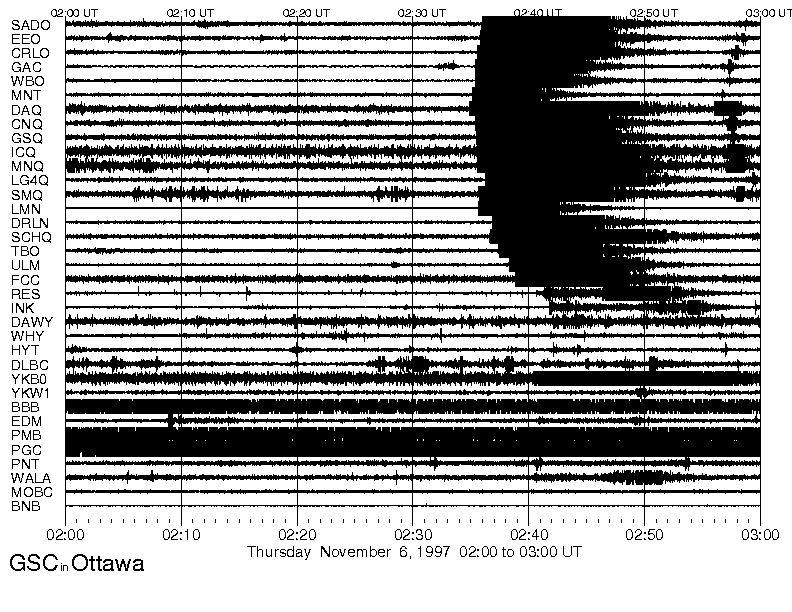
Waveform plot of the earthquake as recorded at 19 stations of the Canadian seismic network. This plot shows the strong main shock at 2:34 UT, and smaller aftershock at 2:56 UT.
November 5, 1997 hourly seismic plot from the Canadian Seismic Network.
Report on the Cap Rouge earthquake from the Canadian National Earthquake Hazards Program. Includes maps, photos, and narrative reports by people who experienced the earthquake.
Press Release:
Nov. 7, 1997 1:13 p.m.
Mainers Asked to Describe Their Earthquake Experience
AUGUSTA, Maine - Mainers who experienced the November 5 earthquake which was widely felt across the state are asked to tell their story to the Department of Conservation's Maine Geological Survey. The "Earthquake Questionnaire" developed in cooperation with the US Geological Survey, asks residents about specific information such as the type of soil and building construction, and the sorts of noises and movements that were felt during the quake. If you would like to fill out the questionnaire, contact the Maine Geological Survey Monday through Friday by phone at (207) 287-2801 or through mail:
Department of Conservation/Maine Geological Survey
93 State House Station
Augusta, ME 04333
e-mail at mgs@maine.gov
"It is important to collect personal observations from many people as soon as possible in order to establish the size of the area affected, and the various types of effects people felt in different areas," remarked State Geologist Robert Marvinney. "This information helps seismologists understand the way that seismic waves travel through the bedrock crust of Maine." The November 5 earthquake registered 5.1 on the Richter Scale and occurred at 9:34 pm EDT a few kilometers southwest of Quebec City. Modern seismographs have been monitoring Maine earthquakes only since the 1970's, and having similar first-hand reports for this earthquake will help to estimate the sizes and locations of historical earthquakes that occurred before modern equipment was available.
Preliminary report on the Cap Rouge, Quebec, earthquake by the Maine Geological Survey, as the 1998 December Geologic Site of the Month. This report includes a record of the event from the seismic station in Milo, and an isoseismal map of intensities reported across Maine.
Reference:
Nuttli, Otto W., 1973: "The Mississippi Valley Earthquakes of 1811 and 1812; Intensities, Ground Motion, and Magnitudes," Bulletin of the Seismological Society of America, v. 63, No.1, p. 227-248.
Last updated on January 26, 2015