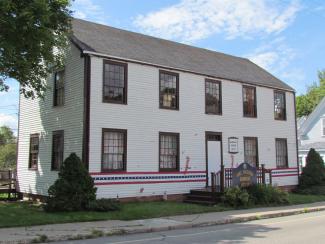
Fort Sullivan was built to protect the small fishing settlement and aid in the enforcement of embargoes against the British. The site was considered the easternmost boundary of the United States and sat on a bluff on Moose Island at the mouth of the St. Croix River. The fort was roughly five acres and consisted of three batteries, three blockhouses, a store magazine, an artillery storehouse, and an unfinished regent's redoubt. On June 1, 1812, President James Madison declared war on Great Britain. Two years later, the British formed a naval blockade of New England ports. British naval forces quickly gained control of eastern Maine, including Fort Sullivan. The name of the fort was changed to Sherbrooke and was intended to be part of a settlement for British Loyalists called New Ireland. The fort was returned to the United States at the end of the War of 1812. Today, all that remains of Fort Sullivan are the officers barracks which were moved to Washington Street and now is a museum and offices for the Border Historical Society. Shead High School now covers most of the original site.
Year Listed: 1969
For more information: https://npgallery.nps.gov/NRHP/AssetDetail?assetID=4a83dc89-0a4c-4c94-bf76-b9942b8b5781https://bhssociety.com/
