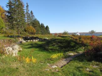
Located in Fort Point State Park, Fort Pownall looks out to where the Penobscot River meets Penobscot Bay. Originally the outer walls of the fort were ninety feet long and ten feet high and surrounded by a moat fifteen feet wide and eight feet deep with palisades placed in the middle for more protection. A drawbridge was used to enter the fort. Within the walls was a forty-four-foot blockhouse standing two-stories tall with diamond shaped flankers at each corner for riflemen. The whole fort was constructed of squared timbers, dovetailed at the corners and tree-nailed. It was built to defend the Penobscot Bay during the French and Indian War, but never saw action. In 1775, during the American Revolution, British forces confiscated all guns and ammunition from Fort Pownall. That same year, Colonel Cargill of the Continental Army burned the fort down and filled the moat to ensure British forces could not use it. Presently, only the foundations and earthworks remain.
Year Listed: 1969
For more information: https://npgallery.nps.gov/NRHP/AssetDetail?assetID=4b8de860-a481-4c17-9c0a-4c01eab42f34
https://www.maine.gov/dacf/parks/docs/brochures/FortPoint.pdf
