DACF Home → Bureaus & Programs → Maine Natural Areas Program → Communities, Plants, and Animals → Natural Community Fact Sheets → Riverside Seep
Printer Friendly Fact Sheet - 760 KB pdf (Get a free copy of Adobe Acrobat Reader)
Riverside Seep
Scientific Name: Circumneutral Riverside Seep; State Rank: S2
- Community Description
- Soil and Site Characteristics
- Diagnostics
- Similar Types
- Conservation, Wildlife and Management Considerations
- Distribution
- Characteristic Plants
- Associated Rare Plants
- Associated Rare Animals
- Examples on Conservation Lands You Can Visit
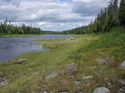
Community Description: This type can include graminoid dominated, graminoid/forb, or shrubby vegetation, often with all three forms adjacent to one another. Shrubs include sweetgale, willows, and alders, either low or tall depending on how recently they have been scoured by ice. An array of forbs and graminoids grows among the shrubs or downslope on the shore. Forbs and graminoids are best developed in areas with only sparse or low shrubs and include fen indicators such as sticky false asphodel, grass-of-parnassus, various sedges and grasses, and forbs both native (various asters, Canada goldenrod, rose twisted-stalk) and introduced (clovers, ox-eye daisy, cow vetch). The bryoid layer is typically extensive, and features numerous bryophytes other than peat mosses. Back to top.
Soil and Site Characteristics: These riparian seeps are below the annual high water mark on a substrate of unconsolidated, coarse textured soil and are constantly saturated by groundwater seepage. The substrate varies from fairly steep gravelly banks with locally extensive moss cover to lower shore flats with stabilized cobble. This type is restricted to larger rivers where spring floods and ice scour maintain a semi-open shore, versus a shoreline of dense shrubs. Continued exposure of glacial tills produces comparatively high pH. Back to top.
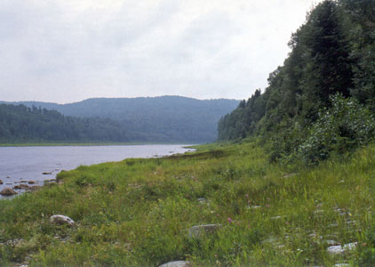
Diagnostics: Intermingled short graminoids, forbs, and shrubs grow on an open rivershore. The substrate is usually unconsolidated sandy to gravelly soil, saturated by groundwater discharge. Indicator species include grass-of-parnassus, hidden-scale sedge, and sweetgale. Back to top.
Similar Types: Circumneutral Fens contain many of the same species but occur in a peatland setting, not on a rivershore. Tall Grass Meadows, which may be adjacent to these seeps, are more homogeneous and are dominated by tall graminoids, particularly bluejoint grass. Laurentian River Beach vegetation occurs on somewhat drier cobble or sand substrates and includes few if any sedges. Back to top.
Conservation, Wildlife and Management Considerations: The structure and richness of this community is linked to naturally fluctuating water levels and occasional ice scour. Maintenance of an intact forest buffer is important, both for light conditions and for ensuring the flow of seepage waters. Many seeps are protected along the upper portions of the St. John River, but elsewhere conservation depends on the individual landowner. Some sites have been degraded by clearing the adjacent overstory. Foot traffic has been light and poses no threat, but where off road vehicles use the shore, the effects can be devastating. Back to top.
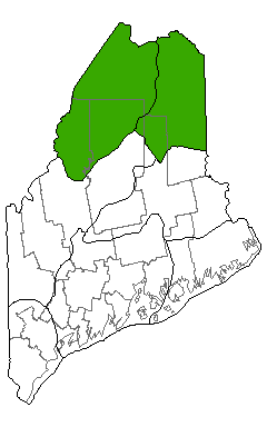
Distribution: Known primarily from the St. John River and sparsely on other northern Maine rivers and lakes, west to other parts of northern New England (New England - Adirondack and Laurentian Mixed Forest Provinces). Many Canadian affinities, but distribution there unknown. Landscape Pattern: Small Patch, linear. Back to top.

Characteristic Plants: These plants are frequently found in this community type. Those with an asterisk are often diagnostic of this community.
- Sapling/shrub
- Beaked hazelnut*
- Bush-honeysuckle*
- Meadowsweet
- Mountain alder*
- Mountain maple*
- Red-tipped willow
- Shining willow
- Speckled alder*
- Dwarf Shrub
- Shrubby cinquefoil*
- Sweetgale*
- Herb
- Bluejoint
- Common horsetail*
- Dwarf raspberry
- Field mint
- Flat-topped white aster
- Fowl mannagrass
- Grass-of-parnassus
- Purple-stemmed aster
- Sticky false asphodel
- Swamp buttercup
- Tall meadow-rue
- Wild strawberry*
- Auricled twayblade
- Black sedge
- Furbish's lousewort
- Garber's sedge
- Glaucous rattlesnake-root
- Mistassini primrose
- Mountain timothy
- Northern gentian
- Northern painted-cup
There are no documented rare animals associated with this natural community.
Examples on Conservation Lands You Can Visit
| Example | County |
|---|---|
| Allagash Public Lands | Aroostook Co. |
| St. John River Preserve | Aroostook Co. |