DACF Home → Bureaus & Programs → Land Use Planning Commission → Featured Projects → Location of Development (Adjacency) → Rule Revisions Summary
Location of Development (Adjacency) Rule Revisions Summary
Last Updated: April 3, 2026
The LUPC recently updated its adjacency principle, which is an initial screen for where new zones for development of a residential subdivision or business can be created. This high-level screen is just the first step – the rezoning process still applies and permits would still be required for most uses. The adjacency principle guides most development toward existing development and away from undeveloped areas. This helps lower tax burdens, ensures land remains available for forestry, agriculture and recreation, and promotes the health of existing communities.
Key Objectives of the Adjacency Rule Changes
- Guide new development near town. Instead of basing new zones on existing development – which may be remote – focus rezonings to areas within a mile of a public road and within seven miles of rural hub communities that provide services. In townships and plantations directly abutting a rural hub, some zones for residential subdivision could locate within five miles of a public road.
- Limit new development farther from town, while recognizing the changing economy. Limit rezonings farther from rural hubs to types that depend on proximity to natural resources or are connected to recreation
- Continue to protect the environment and natural resources. New development zones are not allowed on undeveloped or lightly developed lakes, even if within one mile of existing development. Existing requirements that any rezoning not have an undue adverse impact on the natural resources, along with all environmental permitting standards, remain in place.
- Improve predictability of rezoning for property owners and the public. Locations where rezonings could be considered are tied to predictable factors such as the location of designated rural hubs and public roads, instead of to a shifting pattern of scattered development. This makes planning for the future easier.
Since the early 1980’s, the LUPC’s comprehensive plans have said that the policy should be updated. Maine’s changing economy made that need more urgent. Planning ahead now increases economic opportunity and improves protections for remote areas.
This page describes how the new system for applying the adjacency principle works for different types of development, and discusses some of the reasons to update the policy.
Skip ahead to:
- Commercial development
- Residential development
- Businesses that have to be near a natural resource
- Reasons to update the policy
- Primary and Secondary Locations
Zoning for Commercial Development
A proposal for new commercial or industrial development larger than a home-based business may require a rezoning if the property is not already zoned for development. Rezoning for commercial uses would be possible in primary locations if the use is a good fit for the site and the neighboring uses.
Large commercial/industrial facilities that rely on three phase power are sited on a case-by-case basis using criteria (see Section 10.08,B,2 of the proposed rule revisions) incorporated into rule. Home based businesses were also considered in the rule changes, and now have some additional options to expand in size. Farm stands are allowed in some places where they were not allowed in the past.
Skip ahead: Primary and Secondary Locations
Zoning for Residential Development
The rule changes apply to proposals to develop residential subdivisions. The rule changes did not affect single family homes on individual lots.
In most cases, development of a residential subdivision requires rezoning and the proposed site must be in a primary or secondary location; the developer must demonstrate that emergency services could be provided; and that lot owners would have legal access. Some subdivisions are allowed by permit if located in a primary location, and if they meet other criteria, such as being close to a road and not on a waterbody. The rule changes also allow rezoning for “low density” subdivisions that have lots in the 12-25 acre range, which is a substantial departure from past policy. Low density subdivisions are only allowed in a certain zone, and only in certain places to minimize fragmentation.
Outside the primary and secondary locations, the rule changes allow residential subdivisions on some lakes that are already developed with camps or homes, and near motorized or multi-use trailheads, but eliminated options for residential subdivision on undeveloped lakes.
Camps are common on lakes in the Commission’s service area, and subdivision near a cluster of camps was possible under the old adjacency system. The goal of the rule changes was to continue to allow camp subdivisions but to proactively direct them toward lakes that are already developed, and away from undeveloped lakes. The new rules use information contained in the lakes management program, and some basic criteria, to determine if a lake is developed enough to qualify for residential subdivision. (For more information about adjacency on lakes, see Considerations for Rezoning on Lakes.)
Skip ahead: Primary and Secondary Locations
Zoning for businesses that have to be near a natural resource
Not all uses can locate “near town” in a primary or secondary location: some uses are resource dependent. Examples include operations that process forest products to reduce bulk and make them cost-effective to transport; extraction of natural resources such as water and gravel; the rental of gear on-site for recreation in areas that are distant from town; and trail centers that need certain kinds of terrain and a lot of open space to operate. These resource dependent uses should be located in a manner that does not undermine the quality of the surrounding natural resources or unduly increase the demand for services.
The rule changes identified types of locations for each use and established criteria. For example, businesses that supply recreational day users with gear or food may locate near busy multi-use trail heads or boat launches, so long as there is enough space for parking and activities would not create a problem for neighboring uses or resources.
Reasons to Update the Adjacency Policy
Before the adjacency policy was updated, rezoning for development could be proposed anywhere within a mile of existing development. The one-mile test was a blunt planning tool, long-recognized as needing improvement. Existing, dispersed development provided a springboard for new development into remote areas or onto undeveloped lake shores. This can affect the cost of providing public services (e.g., fire protection, ambulance) and impact forestry operations, wildlife habitat and the character of the UT.
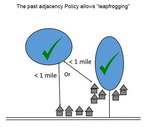
Leapfrogging
Many people agree that the best place for residential subdivision is “near other development.” Camps are common in the Commission’s service area, especially around lakes, and tend to be scattered across the landscape (sort of like freckles). Before the adjacency policy was updated, new zones for residential subdivisions could be within a mile of an existing group of homes or camps, no matter where they were located. Because of the historical pattern of development, the old adjacency system allowed for new development in scattered locations, which can be hard to serve for fire and ambulance providers. The problem would have increased over time as more homes were built.
Example: Before being updated, the adjacency policy would potentially have allowed residential development on undeveloped lakes and ponds that are within a mile of any group of homes.
Lack of flexibility
The one-mile test was not a nuanced enough tool to locate new types of commercial uses, particularly those that need to be farther from town and closer to natural or recreational resources.
The old adjacency system tended to treat all commercial development the same. When in reality, uses can be pretty different from each other and a more nuanced approach leads to better outcomes.
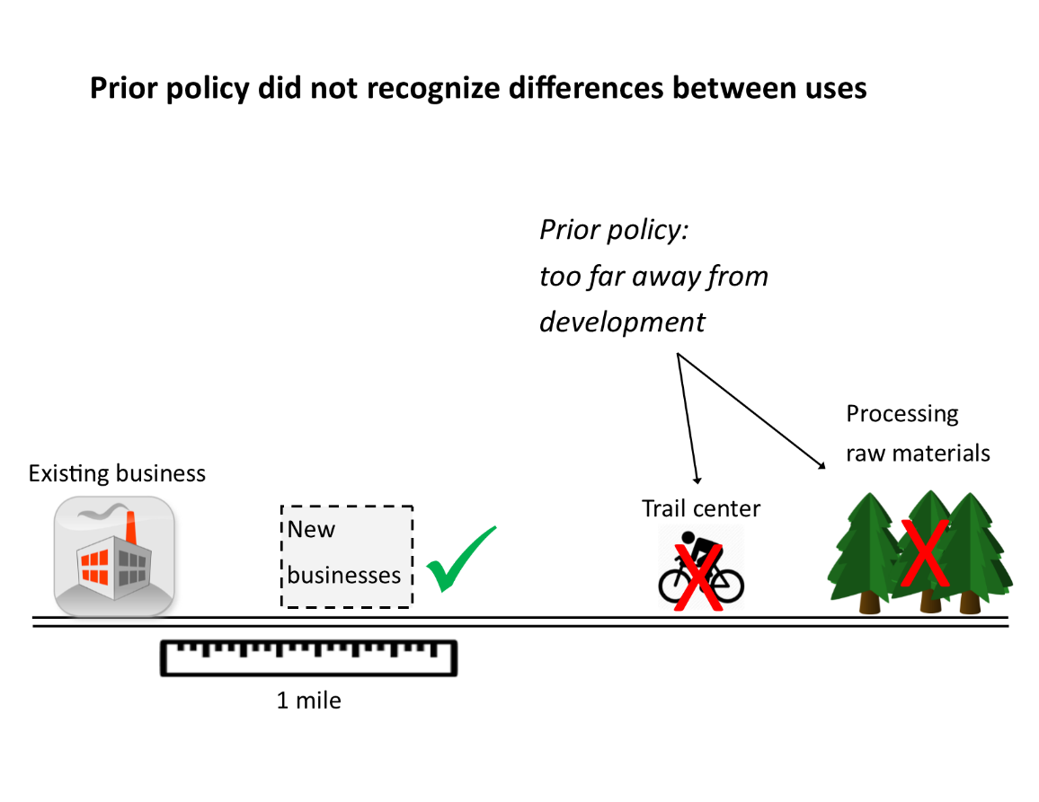
Before being updated, the adjacency policy required most commercial development to be within one mile by road of existing compatible development (shown in the diagram above as a ruler).
Primary and Secondary Locations
The new location of development rules use proximity to public roads and populated areas that provide services to locate most types of residential subdivision and commercial activities. The goal of locating these uses near towns, townships, and plantations with substantial services (called “rural hubs” in the rule revisions) is to provide services in a cost-effective manner and avoid the negative effects of development in distant areas. The negative effects of distant development include higher costs for services such as fire, ambulance, sheriff, solid waste, education, and roads; disruption in land needed for timber, agriculture and recreation economies; impacts to wildlife habitat; uncertain future private road access; and reduced viability of local communities that need a “critical mass” of people in the area to support hospitals, schools, and other community services.
The rule changes guide most residential and commercial development to areas that are generally no more than 7 miles from a rural hub and 1 mile from a public road, which are called primary locations. Some subdivisions can be located up to 3 miles from a public road if a legal right of access and emergency services are available, and these places are called secondary locations.
Guide to the Map:
| Location | Description | What can happen here |
|---|---|---|
Primary Locations  |
|
|
Secondary Locations  |
|
|
Resource based locations (areas not in orange or orange hash marks) |
|
|