DACF Home → Bureaus & Programs → Land Use Planning Commission → Featured Projects → Highland Plantation Zoning Map Update
Highland Plantation Zoning Map Update
Revised: April 23, 2026
Commission Completes Rezoning and Rulemaking Related to Location of Development Criteria in Highland Plantation
At its February 11, 2026 meeting, the Maine Land Use Planning Commission adopted an updated Land Use Guidance Map (Zoning Map) and a rule amendment to Chapter 10 of its rules related to the Location of Development in Highland Plantation.
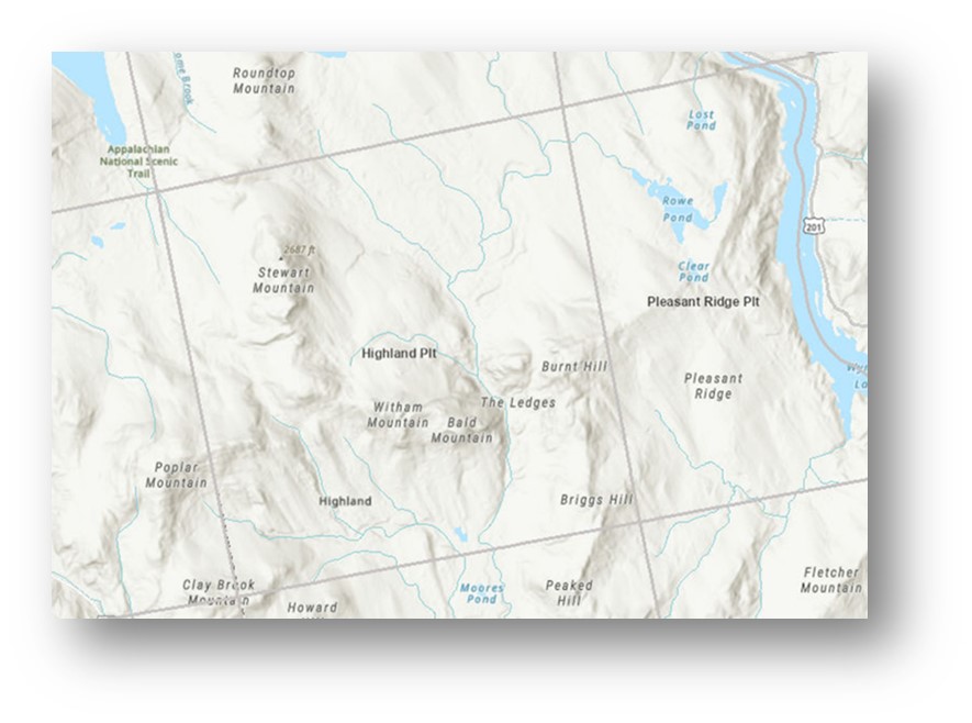
The updated Land Use Guidance Map reflects zoning changes requested by residents and property owners during community meetings to discuss future development and zoning as part of the Commission’s reestablishment of land use authority in Highland Plantation. The changes include rezoning a total of approximately twelve (12) acres in the vicinity of the intersection of Long Falls Dam Road and Sandy Stream Valley Road from Residential Development (D-RS) subdistrict to General Development (D-GN); and rezoning approximately ten (10) acres along Old County Road from General Management (M-GN) subdistrict to Commercial-Industrial (D-CI).
At the community’s request, the adopted rule change excludes Highland Plantation from primary and secondary locations under the Location of Development rules. This effectively prevents future petitions to rezone land for most development subdistricts that allow for general commercial development or residential subdivisions.
Background
Highland Plantation was originally part of the Commission’s jurisdiction and service area. After a local process to develop a comprehensive plan and land use ordinance, Highland Plantation assumed local land use authority from the Commission in July 2016.
At the annual Plantation meeting on April 26, 2025, residents in attendance voted to repeal the comprehensive plan and land use ordinance. Plantation officials subsequently submitted a petition to return to the LUPC service area.
On August 13, 2025, the Commission adopted a rulemaking for Chapter 17 to reestablish jurisdiction in Highland Plantation. One component of the rule adopts the 2016 LUPC Land Use Guidance Map (Zoning Map) to provide interim permitting guidance until a community-based update process is undertaken.
Materials Related to the Highland Plantation Zoning Map Update
| Date | Project Update or Event | Additional Information |
|---|---|---|
| February 11, 2026 | Commission Meeting |
|
| December 10, 2025 | Public Comment Period Open- Proposed rulemaking to exclude Highland Plantation from primary and secondary locations | |
| November 12, 2025 | Commission Meeting |
|
| October 2, 2025 | Initial draft of an updated zoning map | |
| August 13, 2025 | Commission Meeting | |
| May 14, 2025 | Commission Meeting |