DACF Home → Bureaus & Programs → Maine Geological Survey → Explore Maine Geology → Maine's Coastal Marine Geology → Living Shorelines in Maine
Living Shorelines in Maine
Living shoreline* is a broad term that encompasses a range of shoreline stabilization techniques along estuarine coasts, bays, sheltered coastlines, and tributaries. A living shoreline:
- has a footprint that is made up mostly of native material;
- incorporates vegetation or other living, natural “soft” elements alone or in combination with some type of harder shoreline structure (e.g. oyster reefs or rock sills) for added stability; and
- maintains continuity of the natural land–water interface and reduce erosion while providing habitat value and enhancing coastal resilience.
*Definition adapted from NOAA’s Guidance for Considering the Use of Living Shorelines (2015)
In the past few decades, the majority of Maine’s experience with designing, permitting, and constructing “living shorelines” has been related to stream restoration activities, most notably beneficially reusing woody debris and rocks. Living shoreline techniques have also been employed along Maine’s sandy beach and dune environments in the forms of dune restoration, construction, and beach nourishment through the beneficial reuse of dredged materials, usually from the dredging of a federal harbor. However, Maine’s sandy beaches only account for about 2% of Maine’s overall coastal shoreline. A large majority of Maine’s coast, approximately 40%, is made up of unconsolidated, erodible bluffs. These areas have seen large amounts of development over the past few decades, and an increasing percentage of them have been stabilized by traditional shoreline engineering methods such as installing rip-rap. Although this technique may protect property, it can exacerbate erosion on neighboring properties, and over time, can result in loss of protected resources such as marshes and mudflats due to storms and sea level rise.
As a result, there has been an increased interest by the State and many Maine municipalities to explore employing living shoreline techniques, especially in coastal bluff environments, to help curtail erosion while still maintaining the natural continuity of the land-water interface and providing habitat value.
This page, which will evolve as additional resources are developed, is meant to share some of the projects and resources which have been undertaken by the State in efforts to further coastal resiliency through the use of living shorelines.
Living Shorelines Decision Support Tool for Casco Bay
The Living Shorelines Decision Support Tool for Casco Bay map viewer provides generalized information regarding the potential suitability of living shoreline approaches for sections of shoreline in Casco Bay, Maine. Color coded points along the shore represent the potential suitability of the shoreline for living shoreline approaches, based on a variety of factors, including annualized fetch, nearshore bathymetry, landward shoreline type, seaward shoreline type, aspect, relief, and slope.
State of Maine Projects related to Living Shorelines
Increasing resilience and reducing risk through application of nature-based coastal infrastructure practices in New England (ongoing)
Project Summary Video (courtesy of Greater Portland Council of Governments)
LIVING SHORELINES (final) from IhilaFilms on Vimeo.
Background
This 2-year NOAA-funded Regional Resilience Grant is an extension of the work completed as part of a previous regional project which focused on identifying the challenges of implementing living shorelines in New England. All five New England states (Connecticut, Rhode Island, Massachusetts, New Hampshire, and Maine, along with the project team lead The Nature Conservancy) are developing regional and state-level monitoring protocols for furthering concepts of living shorelines in New England. In each state, projects are being developed to design, permit, construct, and monitor demonstration treatment “living shorelines”.
In Maine, the Project Team includes: State Partners (Maine Coastal Program, Maine Geological Survey, Maine Department of Transportation); Non-Governmental Organizations (Casco Bay Estuary Partnership, The Nature Conservancy - Maine, Maine Coast Heritage Trust, and Brunswick-Topsham Land Trust); and Municipal Partners (Town of Brunswick).
State and federal review and commenting agencies have also participated in various project stages, providing input on project designs and monitoring protocols, including: the US Army Corps of Engineers, National Oceanic Atmospheric Administration’s National Marine Fisheries Service, US Environmental Protection Agency, the Maine Department of Environmental Protection, Maine Department of Inland Fisheries and Wildlife, and the Maine Department of Marine Resources.
GEI Consultants out of Portland, ME teamed with SumCo Eco-Contracting (Peabody, MA) were selected through an RFP process to provide engineering services for the project and have worked with the project team to refine demonstration treatment designs. Additional project support is being provided by EJ Prescott (Gardiner, ME), BMT Fibers (New York, NY), Tensar (Alpharetta, GA), Smith Boat Yard (Brunswick, ME), and Higmo’s, Inc. (Brunswick, ME) who have all worked to develop and supply materials specific for demonstration treatments, and aided in acquiring required materials for the projects.
Demonstration Treatment Sites
The Maine Project Team used the Maine Geological Survey’s Living Shoreline Suitability Support Tool for Casco Bay (Slovinsky, 2017) to help select up to three project sites which had the following common characteristics:
- Had an eroding bluff or eroding marsh toe;
- Was owned by a municipality or project partner;
- Had easy access or access representative of a larger geographic region;
- Had at least a “suitable” rating on the MGS Suitability Support Tool;
- Had a relatively consistent and straight shoreline type that was 150 feet in length;
- Was representative of the overall geography/geology of the Casco Bay region;
- Was proximal to mapped special habitat types;
- Was proximal to supplemental educational or research work; and
- Had educational opportunities.
The Project Team ended up selecting three project demonstration treatment sites. Each site would include a living shoreline “treatment” of approximately 50 feet in length, with a minimum 50-foot natural control. Sites selected included:
- Wharton Point, Brunswick, ME – a section of eroding 2-3 foot high marsh edge adjacent to the Wharton Point boat launch, owned by Maine IF&W and the Town of Brunswick. The site was selected because of its ease of accessibility, visibility to the public, educational opportunities, proximity to other work, the presence of an in-situ log to incorporate into the treatment, and influence of tides, waves, and ice (during the winter season).
- Maquoit Bay Conservation Lands, Brunswick, ME - a section of eroding 2-3 foot high marsh edge on lands owned by the Town of Brunswick, with a conservation easement held by the Brunswick-Topsham Land Trust. The site was selected because of its visibility to the public, educational opportunities, proximity to Wharton Point, and influence of tides, waves, and ice (during the winter season).
- Lanes Island, Yarmouth, ME – a section of highly unstable, eroding 10-12 foot high coastal bluff on an island owned by Maine Coast Heritage Trust. This site was selected because it represented an eroding bluff on an island site (common in Casco Bay, but with unique challenges such as access), visibility, educational opportunities, number of fallen trees, and influence of tides and waves.
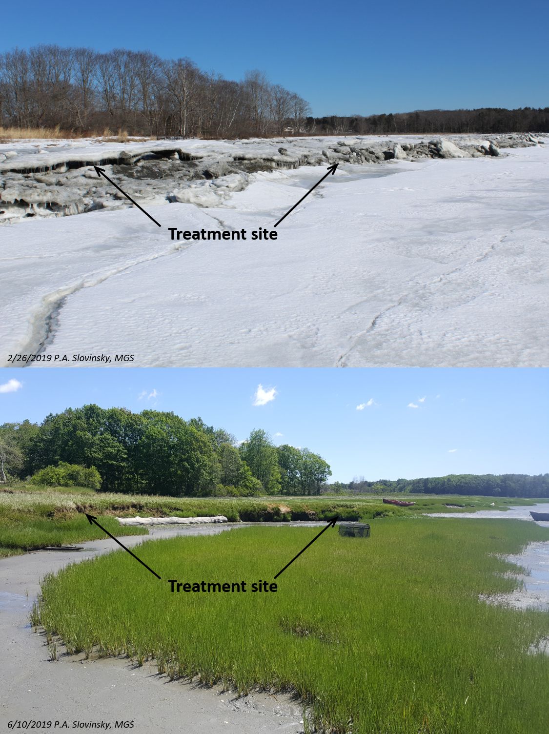
Figure 1. Images depicting the eroding marsh along the Wharton Point, Brunswick, ME demonstration treatment site during winter and summer 2019.
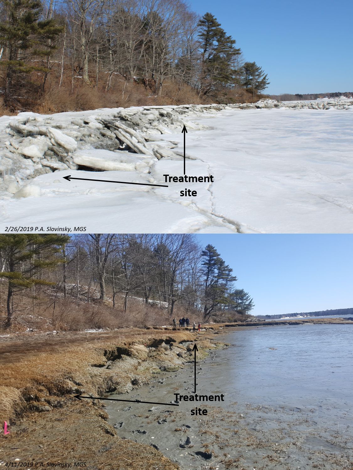
Figure 2. Images depicting the eroding marsh along the Maquoit Bay Conservation Lands, Brunswick, ME demonstration treatment site during winter and spring 2019.
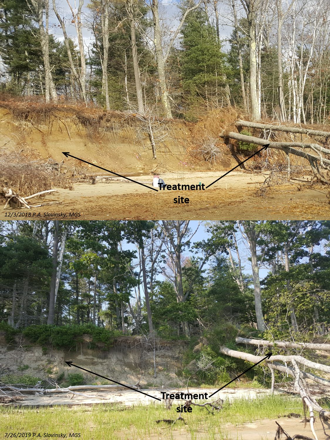
Figure 3. Images depicting the eroding bluff along the Lane’s Island, Yarmouth, ME demonstration treatment site during winter 2018 and summer 2019.
Pre-Project Baseline Characterization
At each site, pre-project baseline conditions were established by MGS and CBEP by installing water level data loggers, erosion pins, conducting RTK-GPS surveys of the edges of the marsh or bluff (Figure 4a), and at the Lane’s Island site, installing a game camera (Figure 4b). Erosion pins are simply 3-ft pieces of rebar hammered into either the edge of the marsh or bluff and periodically measured for erosion (more of the rebar is exposed and measured then pounded flush). The game camera at Lane’s Island was set facing east and set to capture images along the top of the bluff and project site at half-hour intervals during daytime in order to observe daily tide and storm interaction with the bluff. Within the first few weeks of installation, the camera was able to capture the collapse of a large tree after a storm event as shown in the image series in Figure 5. The red line in Figure 5 shows the position of the tree from several images between 10/31/2018-11/14/2018.
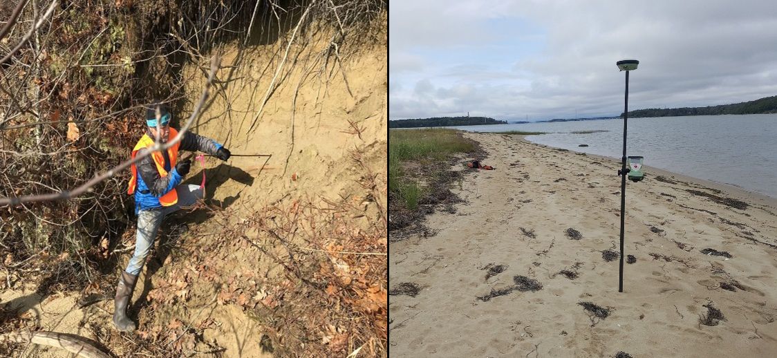
Figure 4a. Images depicting installation of erosion pins and RTK-GPS surveying at Lane’s Island, Yarmouth, ME demonstration treatment sites. Images by M. Craig, CBEP and P.Slovinsky, MGS.
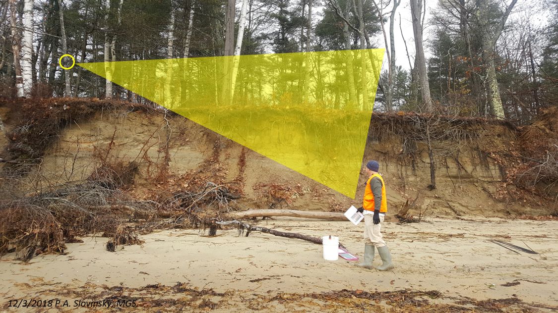
Figure 4b. Image depicting the Lane’s Island, Yarmouth eroding bluff and location of game camera. The yellow cone depicts the approximate direction and line-of-site for captured images.
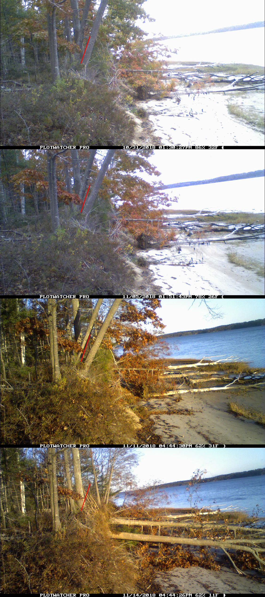
Figure 5. Time-lapse images from the Lane’s Island, Yarmouth game camera capturing failure of several trees along the bluff during winter 2018. Red line approximates the lean of the trees before failure. Images processed with PlotWatcher Pro.
Demonstration Treatments
At each of these sites and in consultation with the Project Team and permit review and commenting agencies, living shoreline demonstration treatments were developed that beneficially reuse naturally occurring materials common to Casco Bay. It was decided that these materials would include recycled (and appropriately aged) oyster shell and fallen trees. Permit applications for these demonstration treatments were submitted to Maine DEP, the US Army Corps of Engineers, and the Town of Yarmouth and permits received. Fifty-foot demonstration treatments permitted for each of the project sites include:
Wharton Point, Brunswick – 50% oyster shell will be placed in customized coir-fabric-based bags and 50% oyster shell placed in Tensar Georeef baskets, below the highest annual tide. This is meant to provide a comparison between completely biodegradable treatment (BMT coir fabric bags) and a new synthetic treatment (Tensar Georeef basket) in terms of efficacy of slowing bank erosion and also survivability in Maine’s harsh climate. The demonstration treatment was developed to incorporate the in-situ log along the edge of the marsh edge. Installation will be completed by volunteers in the Spring of 2020. Plans developed by GEI are presented in Figure 6.
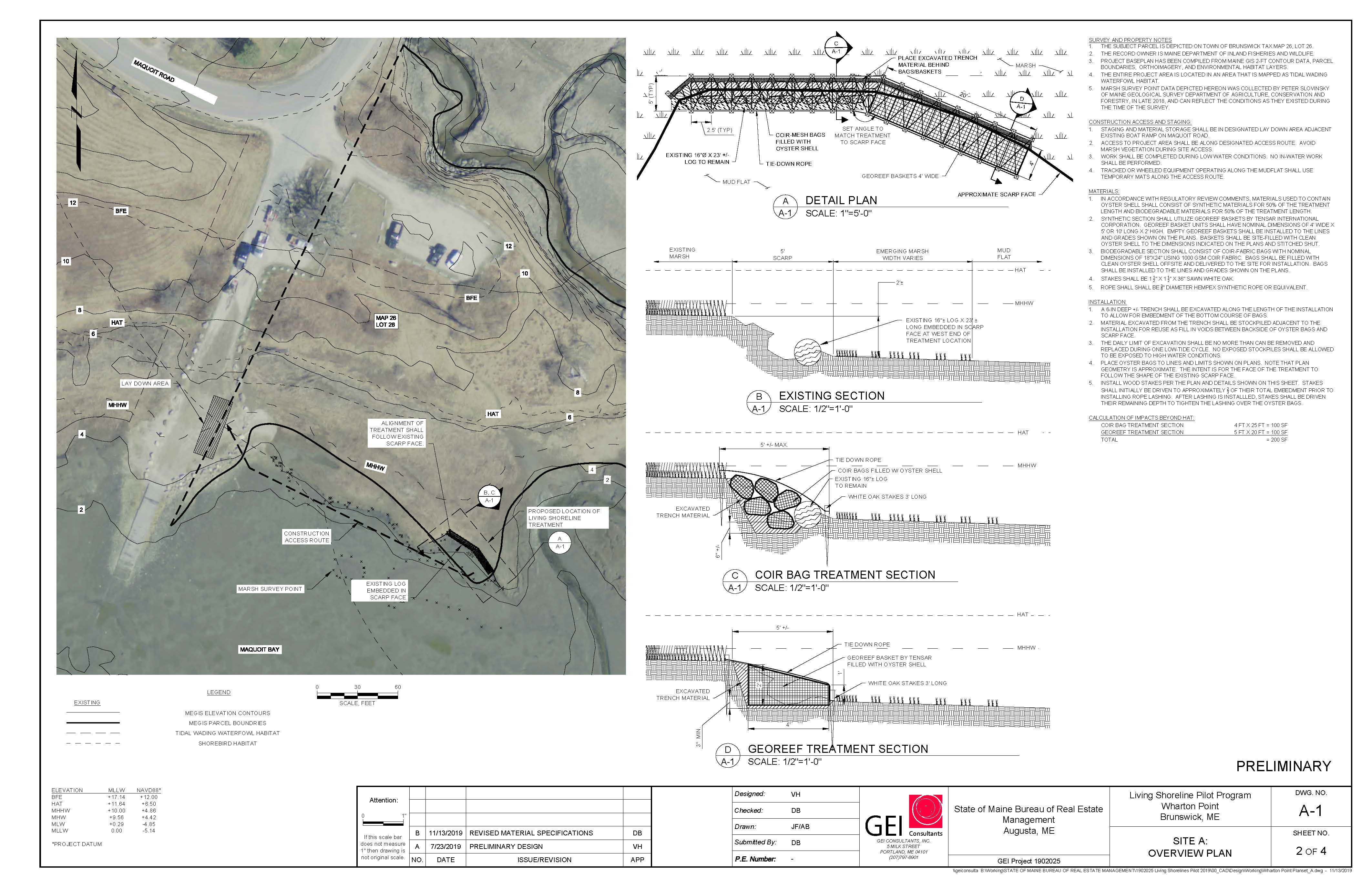
Figure 6. Demonstration treatment plan developed by GEI Consultants for Wharton Point, Brunswick, ME.
Maquoit Bay Conservation Lands, Brunswick – Similar to Wharton Point, the demonstration treatment includes 50% coir-based bags and 50% Georeef filled with recycled oyster shells placed along the eroding marsh edge, below the highest annual tide. One big difference here is the incorporation of “tree runners”, which use 10-12 foot-long straight hardwood tree trunks to provide a ramp for ice to ride up and over the demonstration treatment installation during the winter months. This installation will allow comparison of the survivability of the biodegradable vs. synthetic materials with the no protection site (Wharton Point). Installation will be completed by volunteers in the Spring of 2020. Plans developed by GEI are shown in Figure 7.
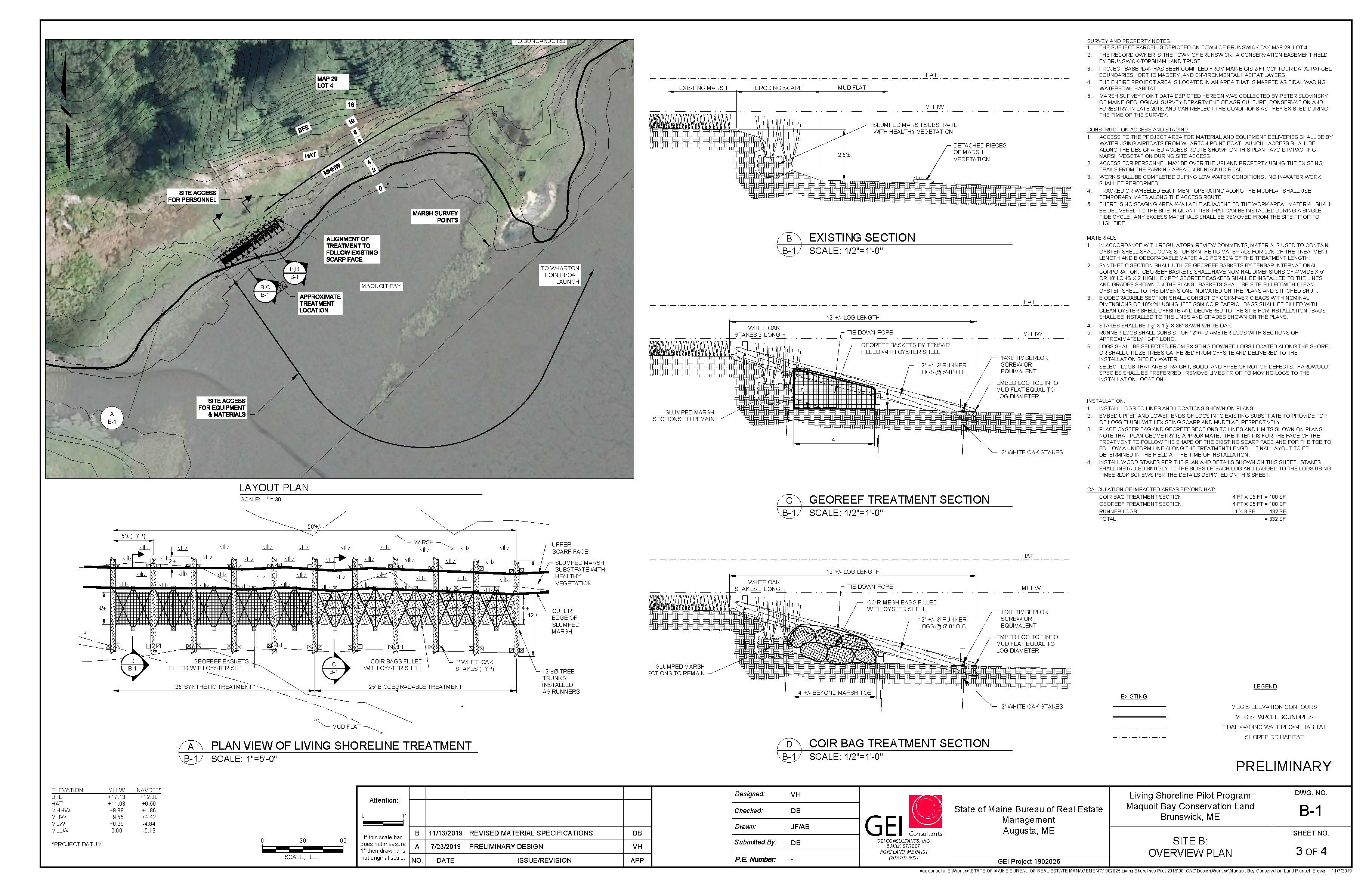
Figure 7. Demonstration treatment plan developed by GEI Consultants for Maquoit Bay Conservation Lands, Brunswick, ME.
Lane’s Island, Yarmouth – The demonstration treatment developed for Lane’s Island beneficially reuses on-site materials, including the numerous fallen trees on the beach and adjacent to the site. A 50-foot segment of the highly unstable, eroding bluff will be regraded to a more stable slope and several trees about to fall over will be removed. Trees will be cut and arranged into a step-like terraced crib structure, and root wads from cut or fallen trees will be placed within the first terrace and at the edges of the installation to help decrease end-effect erosion. Sediment from regrading will be used to fill the terraces, and excess sediment will be placed at the toe of the terrace, above the highest annual tide. Regrading and installation will require the use of heavy equipment (backhoe) and the use of a barge for transporting materials and equipment. After this, each terrace will be planted with salt-tolerant vegetation (becoming progressively less tolerant up each terrace). It is hoped that construction might begin in Spring 2020. Plans developed by GEI are shown in Figure 8.
Figure 8. Demonstration treatment plan developed by GEI Consultants for Lane’s Island, Yarmouth, ME.
Project Construction – Brunswick Demonstration Treatments
Bagging of Oyster Shell – In consultation with the Virginia Oyster Shell Recycling Program, MGS developed a design for 2 shell “bagging stations”. The design included SDR35 piping, rope, plywood, and 2x4s. Bagging stations were constructed by Smith Boatyard in Brunswick, ME. Constructed stations were transported to Brunswick Public Works where aged oyster shell was stored. Coir-bags were placed on the ends of the pipes and the pipes loaded into the bagging stations. A small front-end loader was used to scoop shell out of the pile. A spotter removed visible trash and debris prior to dumping the load onto the plywood cover. Volunteers hand sifted the shell into the pipes and bags and removed any excess trash. The pipes were removed and filled corig bags were then taken to sewing stations where metal camp tent stakes were used to sew the bags shut using a blanket stitch. Bags were packed onto wooden pallets (about 30-35 per pallet) with the sewn-end facing inward and wrapped with pallet wrap. It took teams of 5-6 volunteers three 4-hour days to complete filling 350 bags. Bags were stored indoors at Brunswick Public Works.
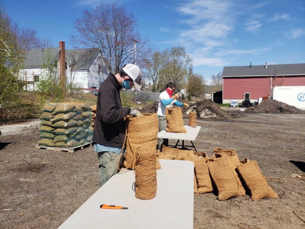
Figure 9. Clockwise from upper left. a) Final bag bagging station design; b) constructed bagging stations c) bagging and sewing activities; and d) wrapped filled coir bags in storage. Images by P. Slovinsky, MGS and D. Bannon, GEI.
Tree-runner Installation at Maquoit Bay Conservation Lands – Town of Brunswick airboat delivered marsh mats to the project site. Volunteers parked at MBCL and wheelbarrowed supplies down the path to the project staging area. Marsh mats were set up and the project site marked on the ground. The locations of the tree runners (every 5 feet) were marked using spray paint and small trenches excavated from the top of the bank. Duckbill anchors (DB88) were driven into the ground and set prior to log arrival. Over the winter, appropriately sized (10-12 foot long, 10-12” diameter) hardwood logs were prepared and stored at Smith Boatyard. On the day of installation, logs were barged over to the project site an hour before high tide from Smith Boatyard, and were rolled off the barge using a pry bar. Volunteers guided the logs into place and the rest of the volunteer team hauled logs up on to the bank at the appropriate locations. Duckbills were attached to the logs using a Timberlok screw and stainless washer. These were later deemed inadequate to hold the logs and replaced with large, galvanized lag bolts. As the tide fell, the logs were positioned at their bottom and duckbills set at the bottom of each log. 18V drills were used, then an electric drill and generator, but hand-ratchets were still needed to sink the lag bolts deep enough into the logs. This effort took 6 volunteers most of the day.
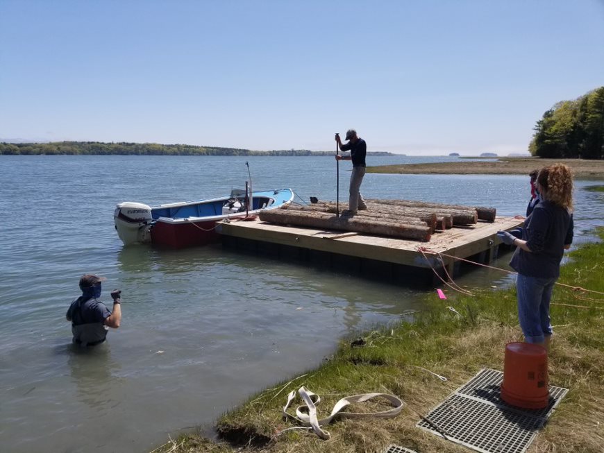
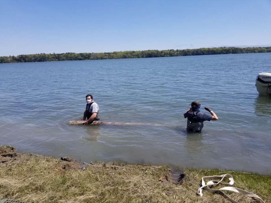
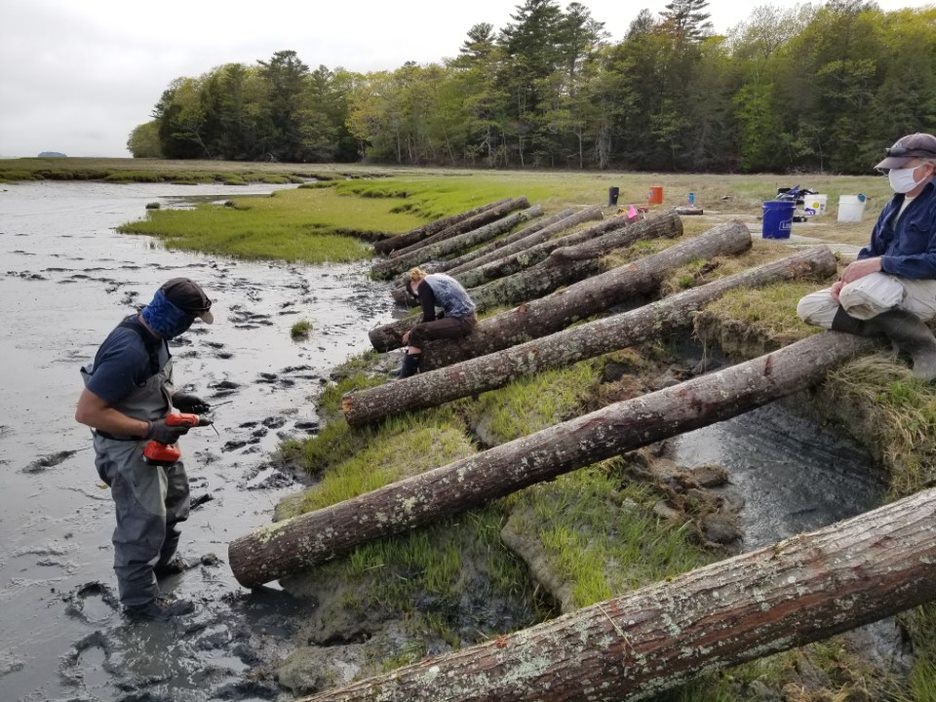
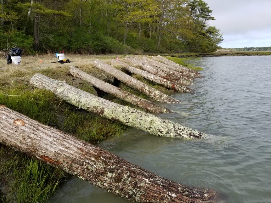
Figure 10. Clockwise from upper left. a) Logs were rolled off the barge at high tide; b) Logs were positioned using 2 volunteers in the water ; c) and d) Logs were secured at high tide at their landward side, and as tide fell, secured at the bottom using duckbill anchors. Images by D. Bannon, GEI, S. Dickson, MGS, and P. Slovinsky, MGS.
Oyster shell cleaning at Wharton Point – Brunswick Public Works delivered loose oyster shell to the parking lot at Wharton Point. After consultation with local shellfishermen, Maine IFW, and Maine DEP over possible dirt and trash in the shell material, a shell sieving and cleaning station was developed in order to remove excess trash and sediment from the oyster shell. This included the construction of a large sieve from an iron grate and 2x4s. Shell was dumped at the top of the grate and using a rake, sifted through the grate. Sediment fell out while plastic and trash was removed by hand. Shell was collected at the bottom of the grate with plastic shellfish baskets. A 300-gallon plastic pool was filled with water by Brunswick Fire and each basket was then dipped and shaken vigorously in the water, removing excess sediment. Once this was completed, baskets of shell were loaded onto the Town of Brunswick airboat for delivry to the project site. Shell cleaning was the most time-and labor-intensive process.
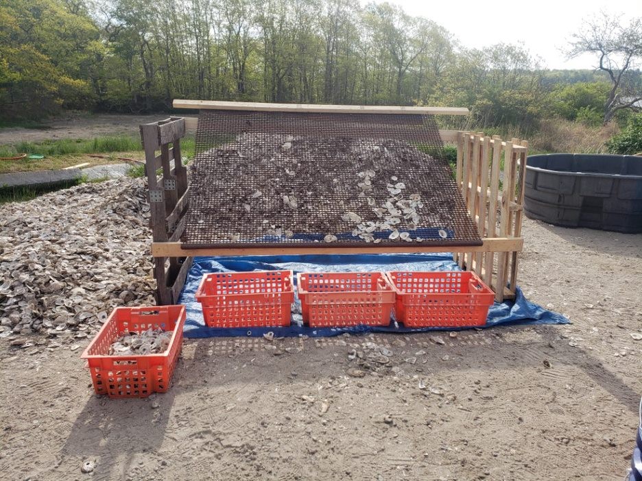
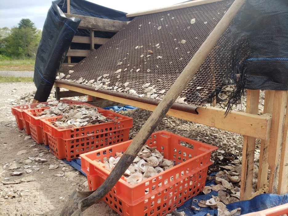
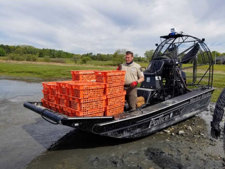
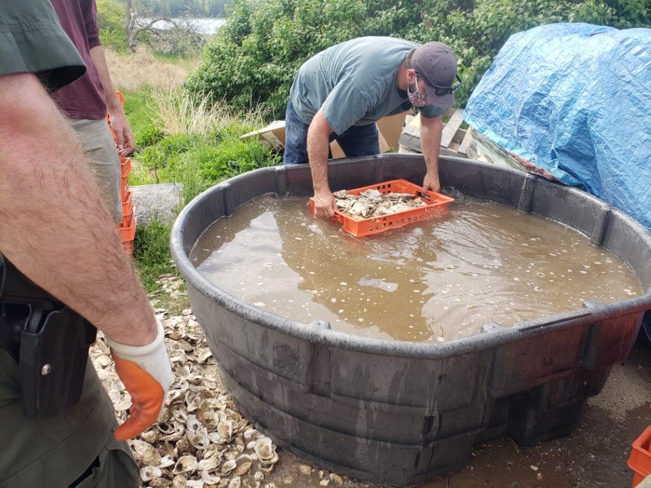
Figure 11. Clockwise from upper left. a) Shell sieving station was constructed using pallets, 2x4 and an old grate; b) Shell was poured at the top and excess sediment and trash removed and collected in plastic shellfish bins; c) Shell was then dipped into a 300-gallon pool and rinsed; and d) Shell was then loaded onto a Town of Brunswick airboat for delivery to Maquoit Bay Conservation Lands. Images from P. Slovinsky, MGS and D. Bannon, GEI.
Installation of GeoReef baskets and coir bags at Maquoit Bay Conservation Lands – Tensar GeoReef baskets were assembled with provided bodkin bars. Small areas of slumped marsh bank were excavated to make room for the baskets. Excess slump blocks were placed above the baskets. Baskets were tucked under the trees that were installed and positioned. Baskets of cleaned shell from Wharton Point were stacked and loaded onto a Brunswick airboat and brought to MBCL. Shell was poured into the GeoReef baskets directly from the plastic shellfish baskets. Once full, the GeoReef basket lids were cut to size and sewn shut with UV-stabilized braid. During construction, it was observed that horseshoe crabs were getting stuck in the crevices between the baskets and the edge of the marsh scarp. Extra shell-filled coir bags were tucked and staked in place above the GeoReef baskets to close off these crevices. Shell-filled coir bags were installed in the other portion of the demonstration treatment (25 feet) by tucking them into available space with as little excavation of the slumped marsh bank as possible. Shell bags were staked with oak stakes and secured using coir twine in a double cross-pattern. This effort took volunteers 3 days to complete.
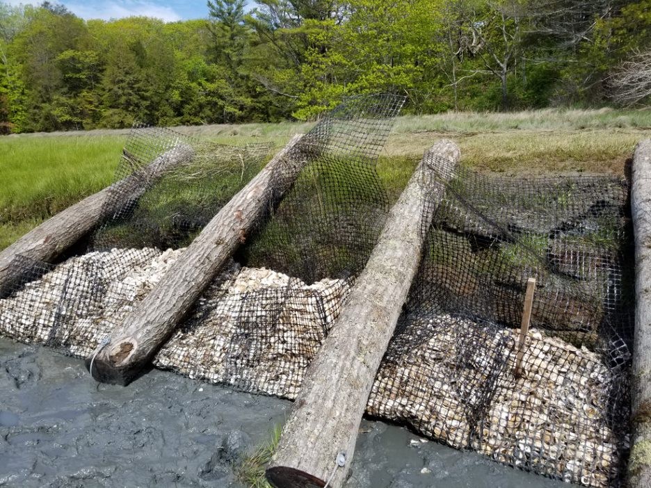
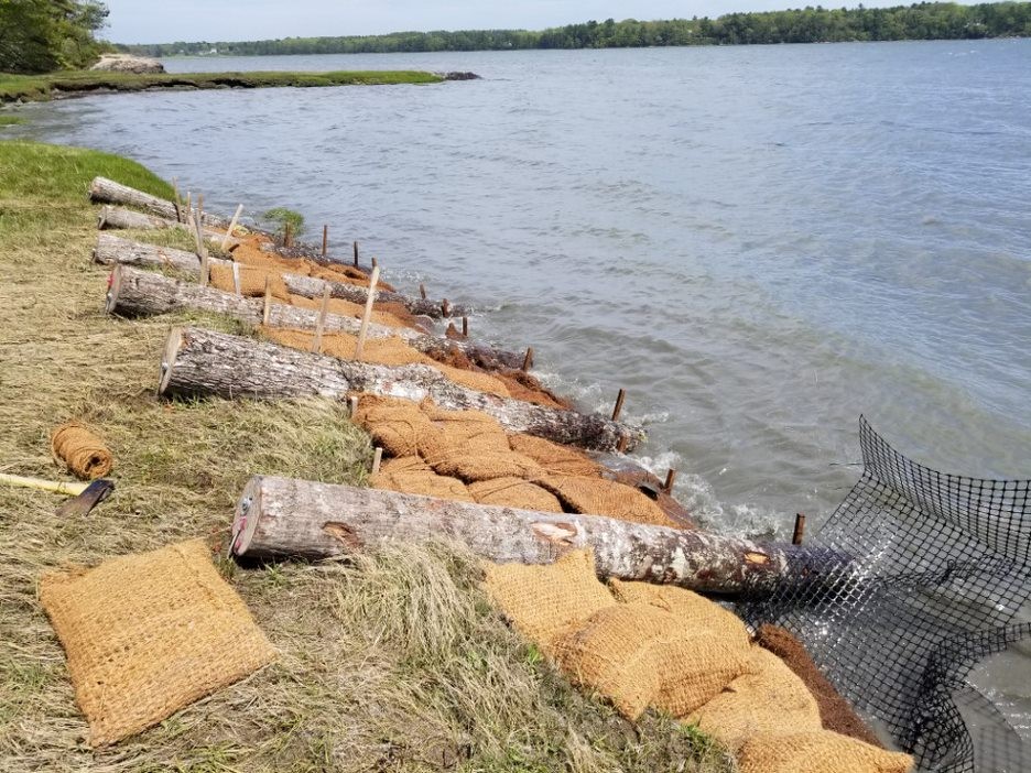
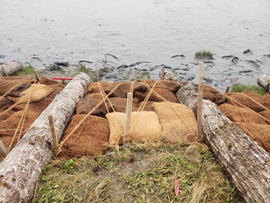
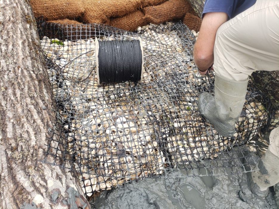
Figure 12. Clockwise from upper left. At Maquoit Bay Conservation Lands, a) Tensar GeoReef baskets were tucked under installed logs and filled with shell; b) Excess crevices above the baskets were filled with coir bags and coir bags were installed along the remainder of the treatment; c) GeoReef basket lids were custom cut and twined closed with a UV-stabilized braid; and d) Coir bags were staked and twined using a double-cross pattern. Images from D. Bannon, GEI and P. Slovinsky, MGS.
Installation of GeoReef baskets and coir bags at Wharton Point – Tensar Georeef baskets were assembled in-place along the marsh edge. Marsh mats were placed from the staging area down to the construction site and wheelbarrows used to deposit clean shell into the baskets. Once baskets were filled, they were secured using oak stakes and UV-stabilized braid. Crevices behind the baskets were filled with excess loose oyster shell to avoid horseshoe crabs possibly getting stuck. The marsh edge along an in-situ log was partially excavated and shell bags were placed, staked, and covered with coir material from several test bags, and double-twined in a cross pattern. The stakes along the top bank were spray painted orange for visibility and safety.
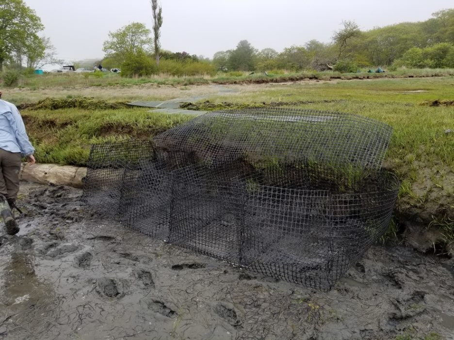
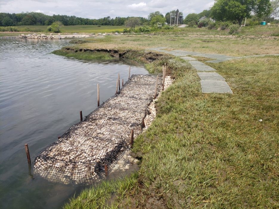
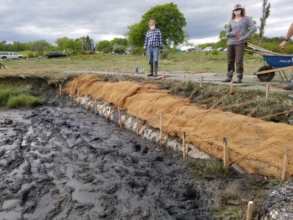
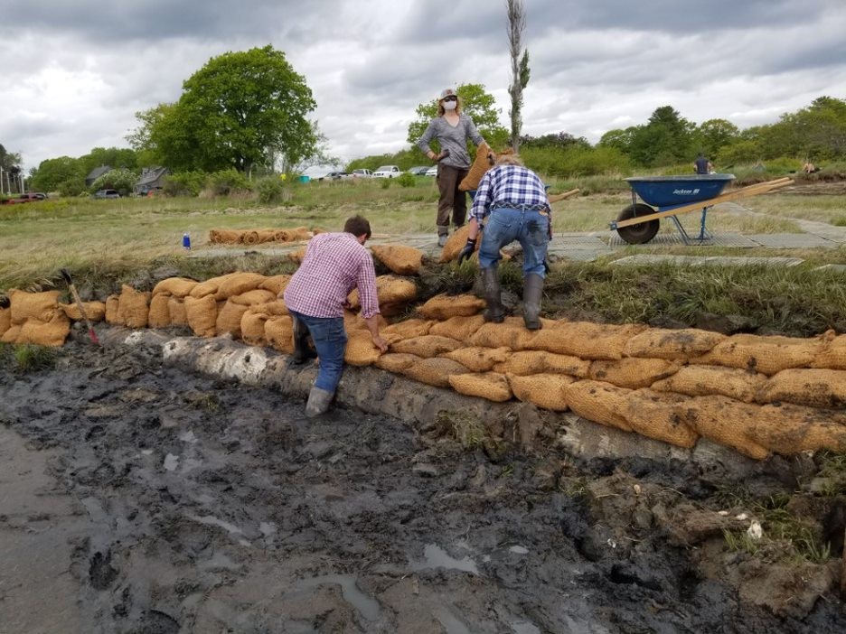
Figure 13. Clockwise from upper left. At Wharton Point, a) GeoReef baskets were assembled; b) filled with shell and closed, staked, and twined; c) After bank excavation, coir bags were placed; and d) Coir bags were staked, covered with coir fabric, and twined. Images from D. Bannon, GEI and P. Slovinsky, MGS.
Completed installation drone imagery – After the treatments were installed, Greater Portland Council of Governments flew a drone and captured orthoimagery and oblique imagery of the installed demonstration treatments.
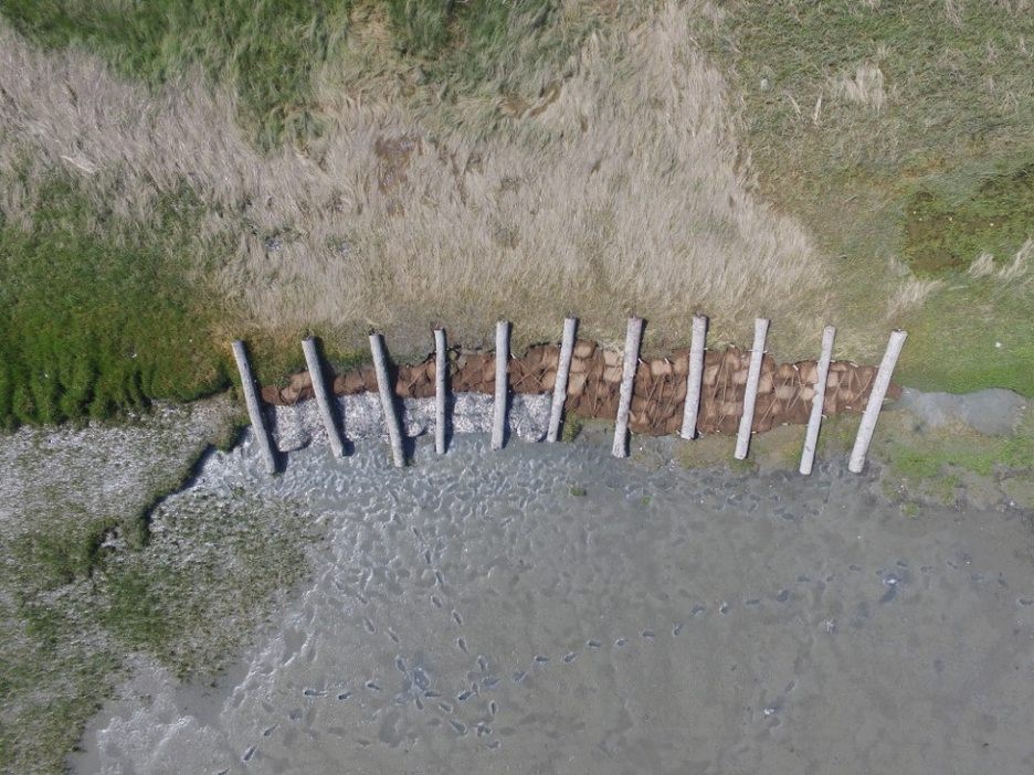
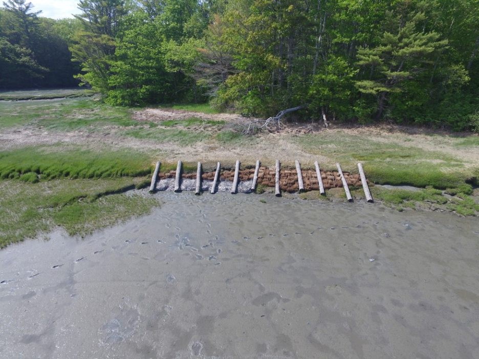
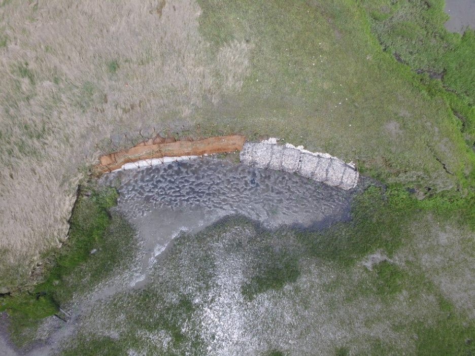
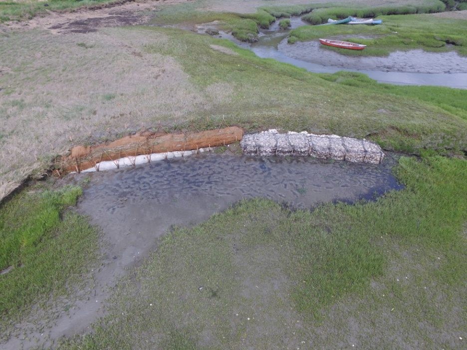
Figure 14. Clockwise from upper left. Orthoimage and oblique image of completed installation at a) and b) Maquoit Bay Conservation Lands; and c) and d) Wharton Point. Images from Rick Harbison, GPCOG.
Long-Term Project Monitoring and Project Performance
Led by Casco Bay Estuary Partnership (CBEP), the Project Team will conduct a long-term (five-year) monitoring program to monitor the efficacy of the different installations in curtailing erosion, the impacts of the treatments to surrounding habitats, survivability of the different installations in Maine’s harsh winter climate, and compare and contrast the synthetic vs. biodegradable installations at Wharton Point and Maquoit Bay Conservation Lands. An additional specific goal of monitoring includes keeping track of the performance of the synthetic portions of the installations in order to limit any release of plastics into the marine environment. Monitoring will include the use of elevation and vegetation transects, RTK-GPS surveys, picture posts, erosion pins, and game cameras. This Monitoring Program was submitted to the US EPA for Quality Assurance Project Plan (QAPP) approval.
In-depth monitoring is slated to occur in spring and fall of each season and after significant storm events, while more simple monitoring (such as pictures from set locations such as picture posts) will likely be included more frequently. As dictated by monitoring, installations will be repaired and maintained over the project period.
Past Project Outcomes
Building Resilience along Maine’s Bluff Coast (completed)
2-year NOAA-funded Project of Special Merit. Completed in 2017 in conjunction with NOAA, the Cumberland County Soil and Water Conservation District (CCSWCD), and the University of Maine, along with several municipal and state agency partners. Collaborative project to create a first-of- its-kind model to assess vulnerability of Maine’s bluff coastline in Casco Bay, ME. The project explored the effects of current “armoring” of shorelines and the potential for use of “living shoreline” techniques (green infrastructure), developed a methodology for assessing instability of coastal bluffs, Casco Bay bluff case studies, and helped support municipal efforts on bluff management. An education and outreach workshop for a variety of stakeholders was held on September 11, 2017. The effort also helped the Town of Brunswick begin to address bluff management issues at the municipal level.
Some Project Outcomes
- Project Summary Report to NOAA (PDF 3.1MB)
- Appendix A – CCSWCD products (PDF 5.5MB)
- Appendix B – Regulatory Examples (PDF 3.7MB)
- Appendix C – September 11, 2017 Workshop Materials (PDF 30.0MB)
- Appendix D – University of Maine products (PDF 3.2MB)
- Appendix E – Annotated Bibliography (PDF 0.5MB)
- Shoreline Management Assessment (SMA)
- SMA Decision Tree Flowchart
- Bluff Instability Rating Form
- Coastal Planting Guide
- Mackworth Island, Falmouth Case Study
- Mere Point, Brunswick Case Study
- Mitchell Field, Harpswell Case Study
- Town of Brunswick Shoreline Erosion Management Project
Advancing High Resolution Coastal Inundation Forecasting and Living Shoreline Approaches in the Northeast (completed)
2-year NOAA funded Regional Resilience Grant. Developed consistent flood inundation modeling datasets throughout the northeast states (CT, RI, MA, NH, ME); increase understanding and access to living shoreline practices by developing a New England “State of the Practice” report, fact sheets, holding workshops and trainings; and identify and address state and federal regulatory challenges and opportunities regarding the implementation of living shorelines in New England states. A workshop on green infrastructure was held in conjunction with NOAA and the WNERR in May, 2017.
Some Project Outcomes
- New England Living Shoreline State of the Practice Report, Profile Pages, and Living Shorelines Applicability Index
- Regulatory Framework Matrix (Excel, 0.1MB)
- MGS Living Shoreline GIS-based Decision Support Tool (PDF 1.6MB)
- Introducing Green Infrastructure for Coastal Resilience NOAA Green Infrastructure Workshop, held May 2017
- Presentation on living shorelines by Troy Barry, Cumberland County Soil and Water Conservation District (PDF 7.8MB)
- Presentation on living shorelines by Peter Slovinsky, Maine Geological Survey (PDF 6.6MB)
Maine Coastal Property Owner’s Guide to Erosion
Additional Living Shoreline Resources
Last updated on February 9, 2021