DACF Home → Bureaus & Programs → Land Use Planning Commission → Plans, Maps & Data→ P-RP Subdistricts - Resource & Concept Plans → Penobscot River Resource Plan - Lower West Branch
Penobscot River Resource Plan - Lower West Branch
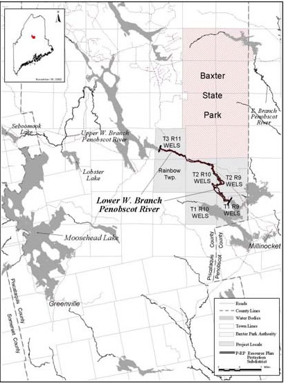
T3 R11 WELS, T2 R11 WELS (Rainbow Township), T2 R10 WELS, T2 R9 WELS, T1 R10 WELS and T1 R9 WELS, Piscataquis County
Zoning Petition ZP 671-A
Last Updated: October 5, 2022
The Resource Protection Plan for the Lower West Branch of the Penobscot River and associated Resource Protection subdistrict will expire on December 26, 2022. The Commission contacted each of the landowners and co-applicants from the 2002 Plan, who did not wish to renew the Plan at this time. The Commission has therefore begun the process of preparing replacement zoning appropriate for the resources present and the existing development within the Plan area.
The Plan covers an approximately 500-foot buffer along each side of the Lower West Branch of the Penobscot River, from 400 feet below Ripogenus Dam to Ambajejus Lake. The Plan includes land in 6 townships in Piscataquis County: T3 R11 WELS, Rainbow Township, T2 R10 WELS, T2 R9 WELS, T1 R10 WELS, and T1 R9 WELS. Expiration of the Plan will not affect existing development and uses. Additionally, expiration of the Plan will not affect any terms of the permanent conservation easement in place along the Penobscot River Corridor.
Materials relating to the petition will be posted here as they become available.
To view PDF documents, you will need the free Adobe Reader. If you need assistance, view our PDF Help page, or email us.
| Date | Project Update or Event | Additional Information |
|---|---|---|
| October 6, 2022 | Consideration of adoption of proposed replacement zoning |
|
| August 22, 2022 | Review Agency Comments | |
| August 15, 2022 | Zoning Petition Materials |
|
| August 15, 2022 | Proposal to Replace Expiring Resource Protection Plan |
|
Prior Actions - ZP 671
Approved by the Maine Land Use Planning Commission
Effective Date: December 26, 2002 (originally adopted in 1981)
2002 Renewal submitted by Great Northern Paper Company, Great Lakes Hydro America LLC, Baxter State Park Authority, Chewonki Foundation, and The Nature Conservancy.
Plan Contents
Download the Entire Plan (PDF 1.6MB)
View the Resource Plan Map
Plan Sections
Resource Protection Plan +
Download Resource Protection Plan (PDF 270KB)
- Contents
- Cover Page
- Preface
- Table of Contents
- I. Application
- II. Purpose and Objectives
- III. Description of Area
- IV. Conservation Easement
- V. Land Use Activities
- VI. Future Land Uses
- VII. Management Agencies
- VIII. Duration of Plan
Close -
Appendices +
- A. Maps of Plan Area
- B. Memorandum of Agreement and Deed of Conservation Easement
- C. Timber Harvesting Standards
- D. Road and Water Crossing Standards
- E. Mineral Extraction Standards
- F. Sign Standards
- G. Definitions
Close -