DACF Home → Bureaus & Programs → Maine Geological Survey → Maps, Publications and Online Data → Using Geologic Maps → Maine Peat Resource Evaluation Maps
Maine Peat Resource Evaluation Maps
What are Maine's peat resources?
Peat has been used for many years in agriculture and horticulture primarily because of its ability to retain many times its own weight in water. It has also been used as a domestic fuel for hundreds of years. At the present time, virtually all of the peat harvested in the United States is used in agriculture and horticulture. Recent estimates suggest that there are as many as 6,000 to 8,000 individual peat depostis in Maine covering a total land area of 500,000 to 750,000 acres. However, only some of these peat deposits have economic potential.
Maine Peat Resource Evaluation Maps
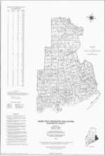
The maps in this series show the location of peat deposits surveyed by the Maine Peat Resource Evaluation Program. A table included on the maps lists the physiographic form, surface area, and estimated resources of each deposit. More information on individual deposits is available in the following publications:
- Bulletin 28 - Peat Resources of Maine, Volume 1: Aroostook County
- Bulletin 29 - Peat Resources of Maine, Volume 2: Penobscot County
- Bulletin 30 - Peat Resources of Maine, Volume 3: Piscataquis and Somerset Counties
- Bulletin 31 - Peat Resources of Maine, Volume 4: Southern and Western Maine
- Bulletin 32 - Peat Resources of Maine, Volume 5: Washington County
- Bulletin 33 - Peat Accumulation Rates in Selected Maine Peat Deposits
- Bulletin 34 - Geochemistry of Selected Maine Peat Deposits
Uses of peat resources information
The information shown on these maps can be used to more accurately assess the energy and agricultural potential of Maine's peatlands.
How to obtain or view these maps
Use the Maps and Publications Search to identify printed and online publications available from the Maine Geological Survey. You can search for maps and publications by geographic area or subject. Search results are linked to online publications. To order printed materials see the ordering instructions.
Last updated on July 26, 2019