DACF Home → Bureaus & Programs → Maine Geological Survey → Maps, Publications and Online Data → Using Geologic Maps → Significant Sand and Gravel Aquifer Maps
Significant Sand and Gravel Aquifer Maps Description
What is an aquifer?
Subsurface water that fills the spaces between particles of rock and soil is called ground water. An aquifer is a water-bearing geologic formation capable of yielding a usable amount of ground water to a well. There are two types of aquifers in Maine: surficial materials and fractured bedrock. In unconsolidated surficial deposits the water fills the pore spaces between the rock fragments that make up the deposits. Coarse-grained surficial materials such as sand and gravel are capable of transmitting large quantities of ground water and are generally the most productive ground water resources in the State. The map sidebar (pdf) contains additional information describing aquifers.
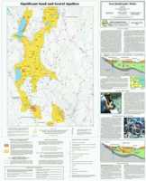
Significant Sand and Gravel Aquifer Maps
Surficial deposits with the potential to yield more than 10 gallons per minute are outlined on Significant Sand and Gravel Aquifer Maps. Yield and depth information about existing wells, springs, and test borings is also shown. For more information, read the map explanation (pdf) or link to our tips for reading aquifer maps.
Uses of aquifer information
When deciding where to locate a domestic or municipal well, aquifer information is very important. Information such as high yield zones in bedrock and the location of sand and gravel aquifers can influence where a well driller locates a well, and what type of well is constructed. Knowledge of aquifers and their recharge areas is also critical when siting possible sources of pollution such as landfills, salt piles, and hazardous wastes. Aquifer maps and texts from the Maine Geological Survey contain information on aquifer favorability and vulnerability and are widely used by local and state officials in making environmentally sound siting decisions, and by well drillers, developers, and geological consultants as a base for detailed hydrogeological studies.
How to obtain or view these maps
Use the Maps and Publications Search to identify printed and online publications available from the Maine Geological Survey. You can search for maps and publications by geographic area or subject. Search results are linked to online publications. To order printed materials see the ordering instructions.
Use our online significant sand and gravel aquifer map list to link directly to the available maps.
Last updated on July 15, 2015