DACF Home → Bureaus & Programs → Maine Geological Survey → Explore Maine Geology → Bedrock Geology → Pennington Mountain Discovery
Pennington Mountain Discovery
Questions and Answers
 Many different news sources have recently covered the geologic discovery at Pennington Mountain. These articles often raise additional questions. This overview and the links within answer the more common questions with correct information and should serve as a resource for those interested in the discovery. Please get in touch with the Maine Geological Survey (mgs@maine.gov | 207-287-2801) for more information.
What is the discovery?
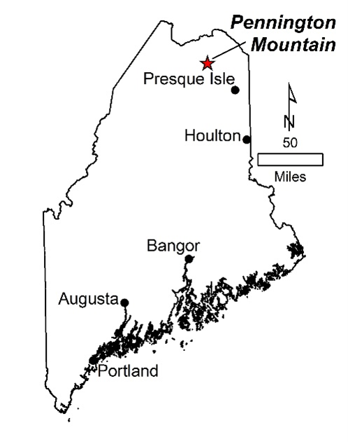
The discovery is an area of rocks at Pennington Mountain on privately owned land in northern Maine with elevated concentrations of rare earth elements (a group of 17 elements) plus additional elements, niobium and zirconium. These elements are on the list of critical mineral resources necessary for economic stability and national security.
How did you find it?
The area was found through an airborne geophysical survey flown in northern Maine in 2021. The eastern side of Pennington Mountain showed up as an area with radioactivity slightly higher than background levels. The scientists reviewing the data were surprised to see the anomaly and immediately started brainstorming ideas for what it could be - was it a manmade feature or natural rock? They knew they needed more information. Dr. Chunzeng Wang at the University of Maine at Presque Isle, who has been mapping northern Maine for the Maine Geological Survey, went out the next day to investigate and collect samples for laboratory analyses. The results showed that some samples were enriched in niobium, zirconium, and the rare earth elements. This finding kicked off a more thorough study to map the extent of the minerals at the surface and to better understand the nature of the mineralization. Results were published in the December 2022 issue of the journal Economic Geology.
What is an airborne geophysical survey?
This survey method is conducted from an airplane to measure rock properties over areas of tens to hundreds of square miles. Sensors that can detect subtle changes in Earth’s magnetic field and natural, low-level radioactivity are placed on an airplane. The airplane then flies in a “mow-the-lawn” configuration, measuring these geophysical properties. The sensors are completely passive, and there are no cameras on the aircraft. The measurements represent averages over areas several hundred feet wide. Airborne geophysical surveys over numerous parts of the U.S. are being funded by the U.S. Geological Survey Earth Mapping Resources Initiative, an effort designed to learn more about geology and our Nation’s critical mineral resources. All data collected from these surveys are made freely available to the public.
What are rare earth elements?
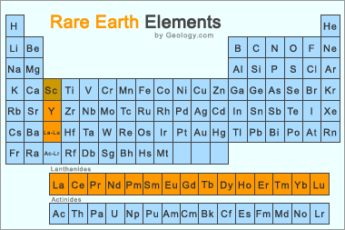 Rare earth elements, despite their name, are not the rarest elements in the Earth’s crust. They are a collection of 17 elements on the periodic table that generally don’t occur in high amounts in any one place, so mineable concentrations are rare. The 17 elements are: scandium, yttrium, lanthanum, cerium, praseodymium, neodymium, promethium, samarium, europium, gadolinium, terbium, dysprosium, holmium, erbium, thulium, ytterbium, lutetium. They are in high demand for many high-tech consumer products like cell phones, computer hard drives, electric and hybrid vehicles, renewable energy technologies like wind turbines, defense technologies, and so on.
Why are rare earth elements considered critical?
Mineral resources are called “critical” when they form materials essential to the U.S. economy and security, but there is a risk of disruption of the supply chain. Rare earth elements are used in many products we depend upon, but the U.S. currently imports over 90% of these important commodities. This reliance on imports means that a disruption in the supply chain would seriously impact our economy and national security. The U.S. Geological Survey’s Earth Mapping Resources Initiative project aims to identify areas across the U.S. that might contain these critical commodities, with the idea that some may eventually be developed into mines that would strengthen our national security, create jobs, and boost the domestic economy.
How much are the minerals at Pennington Mountain worth?
Right now, the value of the mineral occurrence at Pennington Mountain is unknown because there is not enough information to determine the full volume of the rock that contains valuable minerals, and the concentration (i.e., grade) of the critical commodities throughout that volume is unknown. Many other factors go into the value of a mineral deposit, including how difficult it might be to extract the commodity of interest from the rock, how far one might need to ship the mined material to be processed, and the market value. For these reasons, the discovery is defined by geologists as a mineral “occurrence,” not a formal mineral “deposit.”
Is mining going to start soon?
No, it is a long journey from initial discovery to even consideration of development, let alone mining. There are many other known mineral occurrences in Maine of other critical commodities, but none of them have undergone mining. Maine’s mining laws are considered some of the most stringent in the country, and even if mining the mineral occurrence was found to be economically feasible, i.e., that exploration has been done and the amount of material there had enough market value to outweigh the costs associated with the mining and processing, it would take many years of environmental monitoring, land rezoning, and several permits to qualify. The Maine Department of Environmental Protection and the Land Use Planning Commission oversee this process.
If it isn’t going to be mined, why should we care about it?
This scientific discovery should be celebrated for many reasons: it shows that there is still so much more to learn about the geology of Maine, and detailed mapping is critically important at a local level for multiple applications such as water quality and public health; it demonstrates that high-resolution geophysical surveys reveal rock types and geologic settings that we might never have found otherwise; and it is a shining example of how much scientific collaboration can quickly achieve with many different institutions working together – state, federal, and academic groups.
Last updated on December 6, 2022