Home → Annual Reports → 2004 Annual Report
2004 Maine Library of Geographic Information Annual Report to the Legislature & Joint Standing Committees on Natural Resources and State and Local Government
Prepared in accordance with Sec. 1. 5 MRSA c. 158, SUBCHAPTER II-B MAINE LIBRARY OF GEOGRAPHIC INFORMATION
1. THE GEOLIBRARY
1.1 Introduction
The importance of accurate geospatial data for public planning at all levels of government cannot be overstated. Traditionally, Maine state agencies, municipalities and other public entities have developed data to fit their individual needs, but have not been in position to coordinate their efforts or to make their data commonly available and useful to others. The Maine Library of Geographic Information (“the GeoLibrary”) is a virtual library created by the Maine Legislature and governed by an effective partnership of public and private stakeholders to provide cost efficient, web-based access public to public geospatial data.
1.2 Legislative Background
In 2001, the Legislature instructed the State Planning Office to convene what came to be called the Resolve 23 Steering Committee to study the use of GIS in statewide strategic planning. The Committee developed a needs assessment, the conclusion of which formed the basis for the GeoLibrary, its method of governance, and its strategic focus. The Legislature acted on the Committee’s recommendations to create the GeoLibrary in its present form. The Maine Library of Geographic Information was established in April 2002 by L.D. 2116 "An Act to Establish the Maine Library of Geographic Information (Chapter 649)". It is governed by an independent board of public and private stakeholders, it is staffed by agreement with MeGIS, and its projects are funded by a 2003 State bond of $2,300,000 matched with a variety of Federal grants
1.3 Mission / Vision / Strategic Focus
As defined by the Board in consultation with L.D. 2116, the mission of the GeoLibrary is to create an electronic gateway to public geographic information, and to expand and promote the value of geographic spatial data through widespread distribution and innovative use for the benefit of Maine’s citizens.
The GeoLibrary’s vision is to provide state-of-the-art, comprehensive, and ever expanding access to public geospatial information and services, and to facilitate the availability of collections and access for all citizens. This vision encompasses:
- the design and implementation of appropriate data standards;
- the maintenance of the GeoLibrary Portal to ensure coordinated access to these datasets as well as standards compliance with Open GIS Consortium guidelines and the developing geospatial data construct;
- the stewardship of priority statewide spatial datasets and the associated technology essential for sharing geographic data;
- facilitating the modernization and GIS development of local government land records;
- support for smart growth and growth management with datasets and techniques that enable government and communities to effectively plan land use, location decisions, and site designs in a way that will minimize negative impacts on the social, economic and environmental health of Maine;
- multi-organizational data-sharing that results in significant savings in the cost of creating and maintaining geospatial data;
- budgeting and revenue development that prioritizes the strategic importance of geospatial information;
- promoting innovative uses of public geospatial information that fosters economic development;
- implementing education and outreach programs that advocates for the further development of Maine as a national center for GIS research, education, and industrial growth.
To realize its mission and vision, the Board has identified four areas of strategic focus:
1. the development and implementation of statewide data standards to ensure data quality and to enable common use;
2. the development of a web-based distribution system to facilitate access to statewide data holdings;
3. the provision of funding and management for high priority data and database development to support community and regional planning, smartgrowth, and community preservation;
4. the provision of coordination, outreach, and education in support of better public use of geospatial data and to enhance Maine’s position as a national center for GIS research, education and industrial growth.
1.4 GeoLibrary FAQ
Responding to commonly asked questions, the GeoLibrary will not:
- compromise municipal control of data;
- compete directly with private industry.
1.5 Governance
The GeoLibrary is governed by a Board of Directors structured in accordance with L.D. 2116. Its members are appointed by the Governor, the President of the Senate, the Speaker of the House, the UM Chancellor, the Director of the State Planning Office, and professional organizations representing the major stakeholder groups identified in the Resolve 23 Study. A noteworthy strength of the organization is that the Board is independent, term-limited (with the possibility of reappointment) and drawn from public and private sectors. It is therefore uniquely positioned to represent all stakeholders fairly and in a way most likely to foster efficient cooperation and mission success. It’s current membership is:
| NAME | COMPANY | REPRESENTING |
|---|---|---|
| James H. Page, Chair | President / CEO James W. Sewall Company | GIS Vendors |
| Marilyn Lutz, Vice Chair | IT Planning Director, UMaine | University of Maine System |
| Barbara Charry | Biologist/GIS Manager, Maine Audubon Society | Environmental Interests |
| Paul Mateosian | Assessor, City of Bath | Municipal Government |
| Ray Halperin | IT Director, Dept. of Transportation | State GIS Functions |
| Robert Faunce | Land Use Planner, Consultant to Lincoln County | Statewide Association of Counties |
| Dennis Boston | Senior Analyst, Central Maine Power | Utility Interests |
| John Giles | GIS Coordinator, City of Portland | Municipal Government |
| Will Mitchell | President, Mitchell Geographics | GIS Vendors |
| Robert Doiron | Supervisor Unorganized Territory, MRS | Comissioner of Administrative & Financial Services |
| Sean Myers | Kennebunk, Maine | The Public |
| Ken Murchison | GIS Specialist, No. Maine Development Corporation | Statewide Association of Regional Councils |
| Richard Thompson | Chief Information Officer | Maine State Government |
| Vacant | Real Estate & Development Interests | |
| Vacant | President (organization was disbanded) | Maine Science & Technology Foundation |
The GeoLibrary Board meets monthly. Agendas and meeting notes can be found on the GeoLibrary website: http://www.maine.gov/geolib/ Beginning in 2004, the Board organized itself into three standing subcommittees with responsibilities as follows:
A. Finance Committee, with responsibility for:
- budget oversight
- recommending budget actions to the Board for approval
- primary interaction with outside entities on financial issues
B. Policy Committee, with responsibility for:
- policy oversight
- memorializing approved GeoLibrary policies
- recommending policy adoptions and amendments to the Board
- primary interaction with outside entities on policy issues
C. Technical Committee, with responsibility for:
- oversight of all Board projects
- advising the Board on all technical matters
- primary interaction with outside entities on technical issues
The GeoLibrary is staffed by The Maine Office of GIS, Dan Walters, Director, an arm of the Department of Administration and Finance, Bureau of Information Services. MeGIS manages and operates the GeoLibrary website, GIS database and data access facilities.
1.6 Library Structure
The Board views the GeoLibrary’s portal as the central node in a distributed system linking its stakeholders via the web and, in particular, as providing the central point of connection between state agencies and the public as well as other public entities. At the same time, however, it is important to recognize that State agencies have operational requirements that are independent of the Board’s central mission. The Board therefore envisions that state operations will continue to be served by MeGIS using the State’s intranet. The GeoLibrary would then be the central connecting point linking stakeholders to one another and to the State’s data. Schematically:
DATA FLOW
| State Agency | GeoLibrary |
Towns | |
| State Agency | MEGIS Intranet | Portal |
NGOs |
| State Agency | (under construction) |
Private Entities and Individuals |
One commonly asked question is whether MeGIS and the GeoLibrary are redundant. They are not. The GeoLibrary maintains no technical staff, using the MeGIS operations structure already in place to serve its needs. At the same time, the public / private structure of the GeoLibrary Board makes it the most technical and policy effective interface between the state and other GIS users.
2. GOALS AND ACCOMPLISHMENTS
2.1 2004 Initiatives / Major Projects[1]
In support of each of the areas of strategic focus, in 2004 the GeoLibrary undertook the following projects or initiatives:
1. To support the development and implementation of statewide data standards to ensure data quality and to enable common use; the GeoLibrary established statewide standards for parcel data.
- In 2003, the GeoLibrary Board authorized a Standards Subcommittee to develop published standards for digital tax parcel data in support of a grant program for the digitization of municipal property maps and to establish the basic standards for GeoLibrary parcel data. The committee served voluntarily and was composed of representatives from: Bureau of Information Services, Central Maine Power Company, City of Bath, City of Portland, Department of Conservation, Department of Transportation, Greater Portland Council of Governments, Hancock County Planning Commission, Island Institute, James W. Sewall Company, Maine Revenue Services, Maine State Archives, Northern Maine Development Commission and the State Planning Office. Their results were accepted by the Board in 2004 and served as the technical basis for the Parcel Grants Program. These standards are now in the final stages of formal adoption by the State. They are available as Standards for Digital Parcel Files at this website: http://www.maine.gov/geolib/subcommittees.htm
2. To support the development of a web-based distribution system to facilitate access to statewide data holdings the GeoLibrary created a web application to access data on line.
- Also know as cadastral maps, digital property maps show the boundaries of the subdivisions of land for purposes of describing and recording ownership and taxation. Property Maps are one of the most important local government information assets, forming a fundamental base for many municipal activities. Although GIS parcel data cannot replace detailed ground surveys, the data assists municipal officials with functions such as accurate property tax assessment, planning and zoning. Furthermore, a digital cadastre provides the most efficient method of collecting and collating geospatial data for infrastructure development and regional planning. A grant program has been developed budgeting $366,850 of bond funds to digitize property tax maps with awards varying from $1,000 to $10,000. The first round of awards is complete, and the second and final round (for this bond budget) will take place early in 2005. It is noteworthy that because of the GeoLibrary’s unique system of governance, 100% of allocated funds were distributed to the towns. See Attachment 1 for the award list.
3. To support the provision of funding and management for high priority data and database development to support community and regional planning, smartgrowth, and community preservation, the GeoLibrary
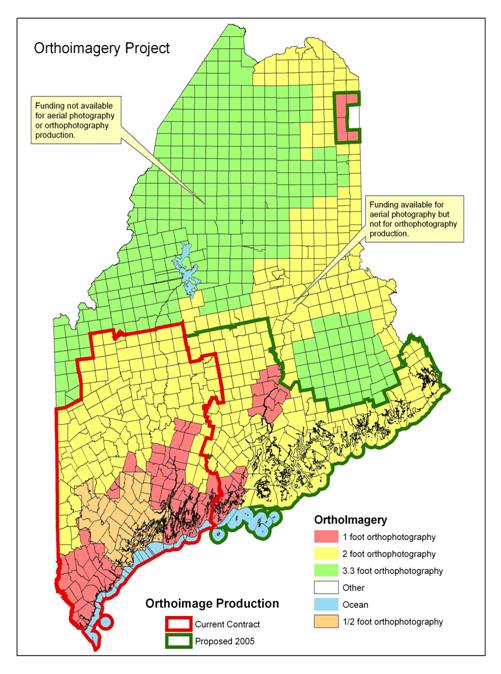
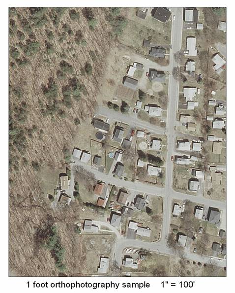
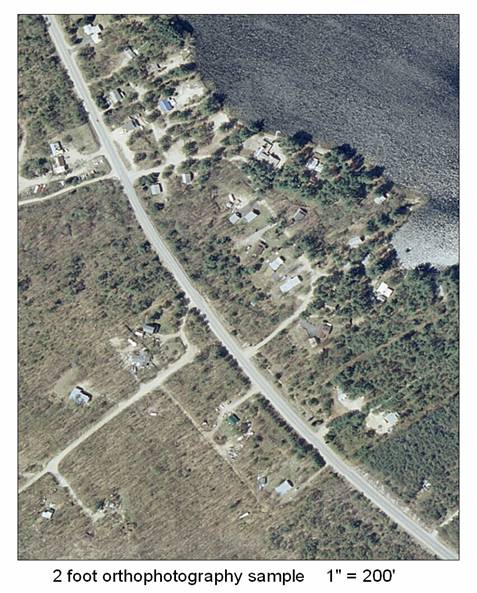
- Implemented a $3.2M project in conjunction with the Federal Government to produce digital Orthoimagery for the state’s organized townships. Digital Orthoimagery are aerial photographs that have been processed to function as "photomaps", having the scale and the measurement characteristics of a map with the qualities and characteristics of a photograph. Digital orthophotos are widely used as a base map or backdrop in GIS on which other layers of mapped information can be viewed or analyzed. Because of the “bird’s eye view”, orthophotos make it easy to view, recognize and understand the relationship of objects on the ground. Digital orthophotos are also used as the source for digitizing ground features to create GIS data layers for specific business functions including road centerlines, building footprints, farm fields, forest types, eelgrass beds and utility & road corridors. Change analysis can then be conducted using orthophotos from different years. Digital Orthoimagery is now under development and will be available for most organized towns in 2005. This effort represents significant cost savings as the cost of producing orthophotos for municipalities individually would be dramatically greater than the realized cost of undertaking a single, statewide project. See Attachments 2 and 3 for samples.
- Initiated a grant program for Maine municipalities to create and upgrade digital parcel maps; and partially funded the development of a new Maine Landcover dataset to assist with growth and natural resource management. The GeoLibrary is using bond funds to provide partial funding for the development of a new Maine Landcover Dataset to assist organizations in planning for growth and monitoring natural resources. Landcover mapping indicates the dominant vegetation or ground cover within a particular 5m x5m square (or pixel), grouped into areas of two acres or more. This project is tightly integrated with federal efforts to map landcover and imperviousness nationwide at 30-meterresolution, and tremendous cost savings were realized as a result. Other contributors to the project include federal agencies (USGS, NOAA, EPA), as well as state agencies (MEDEP, MEDOT, MESPO, MEIFW, MEDWP).
4. To support the provision of coordination, outreach, and education in support of better public use of geospatial data and to enhance Maine’s position as a national center for GIS research, education and industrial growth, the GeoLibrary staffed a booth at the Maine Municipal Association’s 2004 - Technology and Local Government conference; staffed a booth at the 2004 Maine Municipal Association convention featuring a live demo of the Maine Aerial Photography Viewer internet mapping site; sponsored a display at the Maine Science Teachers Association conference promoting GeoLibrary data and projects; and distributed CD sets of GIS data to fifty municipalities containing all the GeoLibrary data holdings, complete metadata, a free GIS software and instructional manuals.
2.2 2005 Initiatives
Pending adequate funding, in 2005 the GeoLibrary plans to undertake the following projects or initiatives in support of each of the areas of strategic focus:
1. To support the development and implementation of statewide data standards to ensure data quality and to enable common use; the GeoLibrary will insure data standards for the GeoLibrary;
2. To support the development of a web-based distribution system to facilitate access to statewide data holdings, the GeoLibrary will create an enhanced web-based portal as the its “front door” for public access to statewide data; and facilitate the development of a virtual GIS network that links statewide geospatial data holdings;
3. To support the provision of funding and management for high priority data and database development to support community and regional planning, smart growth, and community preservation, the GeoLibrary will continue the statewide Orthoimagery project as well as the municipal grant program to create and upgrade digital tax parcel data.
4. To support the provision of coordination, outreach, and education in support of better public use of geospatial data and to enhance Maine’s position as a national center for GIS research, education and industrial growth, the GeoLibrary will continue to disseminate information about the GeoLibrary and GIS generally, as well as provide geospatial datasets to its constituents.
It is crucial to note, however, that financial contingencies could cause the GeoLibrary to curtail or cease operations in 2005 unless adequate support is found to fund staffing and data maintenance costs.
3. FINANCES
3.1 2004 Expenditures
The GeoLibrary Board serves pro bono, and, as noted, its staffing is funded by arrangement with BIS through FY2005. The Board was given authority to administer $2.3M in State bond funds for GIS capital investments in November 2002. The Board then entered a series of cooperative agreements with Federal agencies to garner the required $1.6 million federal match for the approved bond funds. This effort resulted in a number of federal partnerships that have provided federal dollars for Maine GIS initiatives as noted in the following summary.
| Expenditures (spent or encumbered by contract to 12.15.04 | Maine Bond |
Federal Match or Grants |
|---|---|---|
| 1. Infrastructure Development | $5,209 |
$0 |
| 2. Orthoimagery Project | $1,255,372 |
$1,227,318 |
| 3. Maine Parcel Grants Program (04) | $181,862 |
$0 |
| 4. Maine Landcover Project | $120,000 |
$300,000 |
| 5. Archive Project | $10,708 |
$100,000 |
Subtotal |
$1,573,151 |
$1,627,318
|
| Approved by Board vote but not yet encumbered by contract | ||
| 6. GeoLibrary Portal | $100,000 |
$0 |
| 7. Orthoimagery Project (05) | $400,000 |
$400,000 |
| 8. Maine Parcel Grants Program | $184,988 |
$0 |
| 9. Outreach Study | $6,250 |
$15,000 |
Subtotal |
$691,238 |
$415,000 |
TOTAL |
$2,264,389 |
$2,042,318 |
3.2 Projected Budget Requirements
The Board will continue to serve pro bono . Because of State budget requirements, BIS will be unable to provide funding for staff beyond the level required to support State data after 30 June 2005 . Should this occur, the GeoLibrary 's long-term strategies may be compromised . The Board is eager to work with the Legislature, the Governor's Office, and State Agencies to avoid this situation by identifying alternative long-term revenue sources of $250,000-450,000 annually.
The Board also expects to spend or encumber all its bond funds in 2005. It requests consideration for $4,150,000 in new bond funding for FYs 06-07 for the following projects.
| Category | Project | FY06 |
FY07 |
|---|---|---|---|
| Data Development | Complete Orthophoto Project | ||
| Tier B | $270,000 |
0 |
|
| Tier C | 0 |
$330,000 |
|
| orthophotos, update cycle | 0 |
0 |
|
| update statewide landcover | 0 |
$100,000 |
|
| grants - digital property maps | $750,000 |
$750,000 |
|
| zoning and conservation lands | $250,000 |
$250,000 |
|
| merge DOT & E911 databases | $200,000 |
$200,000 |
|
| Standards | zoning, conservation, roads | $200,000 |
0 |
| Data Warehousing | upgrades and validation/conformity tools | $100,000 |
$200,000 |
| build statewide GIS network | $150,000 |
$150,000 |
|
| Applications | development tracking | $250,000 |
0 |
Total by Fiscal Year |
$1,170,000 |
$1,980,000 |
|
Combined Fiscal Year Totals |
$4,150,000 |
4. REQUESTED LEGISLATIVE ACTIONS
The Board requests that the Legislature:
- Define a Board position made vacant by the dissolution of the Maine Science and Technology Foundation. The GeoLibrary Board recommends that the new position be a licensed land development professional.
- Appropriate $256,000 to the Office of Information Technology to support the operations of the GeoLibrary.
- Approve $4,150,000 in new bond funding in support of statewide GIS development as detailed in the above list to include costs for bond administration not to exceed 2% (two percent).
Standard Grants: 54 towns applied, 21 awarded
Cape Elizabeth
Casco
Ellsworth
Falmouth
Freeport
Gorham
Gray
Islesboro
Jackson
New Gloucester
North Yarmouth
Norway
Oxford
Paris
Raymond
Rockport
Rumford
South Portland
Thorndike
Unity
Woodstock
Rapid Grants: 27 towns applied, 24 awarded
Anson
Auburn
Bath
Biddeford
Bridgton
Brooksville
Casco
Castle Hill
Chapman
Cumberland
Denmark
Fort Kent
Harrison
Kittery
Madawaska
Mapleton
Mariaville
Raymond
Skowhegan
Stonington
Sweden
Verona
Woodland
Yarmouth
Attachment B: Map of Orthoimagery Coverage
Attachment C: 1’ Orthoimagery Sample
Attachment D: 2' Orthoimagery Sample
Attachment E: Acronyms & Selected Definitions
| Board | Board of Directors for the Maine Library of Geographic Information |
| GeoLibrary | Common name for Maine Library of Geographic Information |
| GIS | Geographic Information System |
| MeGIS | Maine Office of GIS |
| Resolve 23 | Legislative Committee that drafted the plan that resulted in the MLGI |
| MLGI | Maine Library of Geographic Information |
| USGS | US Geological Survey |
| NOAA | National Oceanographic Atmospheric Administration |
| EPA | Environmental Protection Agency (Federal) |
| MEDEP | Maine Department of Environment Protection |
| MEDOT | Maine Department of Transportation |
| MESPO | Maine State Planning Office |
| MEIFW | Maine Inland Fisheries and Wildlife |
| MEDWP | Maine Drinking Water Program |