September 21, 2022
New: Self-Service Mapping Application (Beta)
We have deployed a simple application to allow public users to create basic maps of towns or similar areas of interest, and export them to PDF format for printing from the user's computer. Please visit the Maps page for access.
June 1, 2022
Announcement: WMS restored to imagery and DEM services
We are pleased to announce that WMS capability has been restored on our orthoimagery and DEM image services. Services which previously had WCS capability will have both WMS and WCS capabilities.
Notice: Maine GeoLibrary COVID-19 Content discontinued
As Maine's COVID-19 response efforts shift to long-term focused support, the Maine Office of GIS (MEGIS) has ended updates of its COVID-19 GIS content. This means that Tuesday, May 31, 2022 was the final day of updates for all MEGIS COVID-19 data tables, feature layers, web maps, and dashboards. The Maine CDC is continuing to track and report COVID-19 data; to access its data and dashboards, please visit the Maine CDC Coronavirus 2019 (COVID-19) page at: https://www.maine.gov/dhhs/mecdc/infectious-disease/epi/airborne/coronavirus/data.shtml.
April 5, 2021
MaineIT completed a system update on 4/3/2021 that restored normal access to the full resolution imagery services hosted by the Maine Office of GIS. The services have been tested and monitored over the last 48 hours and have maintained consistent service over that period. Please feel free to return to normal use of these services to support your GIS workflows. If you experience disruption of normal imagery access, please note the specific image service failure and the time and email your information to the Maine GeoLibrary at GeolibraryBoard.OIT@maine.gov
March 22, 2021
The intermittent problem resulting in GIS image service dysfunction has returned. The Maine Office of GIS has confirmed the root cause is not within the Enterprise GIS itself. Maine IT and the Maine Office of GIS have an ongoing effort underway to determine the source of this issue. We do not yet have an ETA for resolution; we will update this posting when the services return to normal. GIS users may find the following imagery service alternatives helpful in the interim:
- ESRI imagery accessible directly from the GIS desktop applications
- NAIP from USDA-FSA: https://gis.apfo.usda.gov/arcgis/rest/services
- The National Map:
- https://basemap.nationalmap.gov/arcgis/rest/services/USGSImageryTopo/MapServer
- https://basemap.nationalmap.gov/arcgis/rest/services/USGSImageryOnly/MapServer
- https://services.nationalmap.gov/arcgis/rest/services/USGSNAIPImagery/ImageServer
- https://basemap.nationalmap.gov/arcgis/rest/services/USGSImageryTopo/MapServer
- https://basemap.nationalmap.gov/arcgis/rest/services/USGSImageryOnly/MapServer
March 15, 2021
GIS image services have returned to normal function. MaineIT applied an update to the storage environment that appears to have had a positive impact on service. The Maine Office of GIS is monitoring and collecting data to help affirm this is a longer term fix. In the meantime, please feel free to resume regular use of these services. If users encounter a renewal of the imagery performance issue, or any newly impacted items, please reach out to us with details.
March 10, 2021 - Disruption to Imagery Services
The intermittent problem resulting in GIS Image service dysfunction has returned this morning. We have affirmed the root cause is not within the Enterprise GIS itself. MaineIT and MEGIS have an ongoing effort underway to determine the root source of this intermittent problem.
We do not yet have an ETA for resolution, will update this posting when service returns to normal. GIS users may find the following imagery service alternatives helpful in the interim:
- ESRI imagery accessible directly from the GIS desktop applications
- NAIP from USDA-FSA: https://gis.apfo.usda.gov/arcgis/rest/services
- The National Map:
September 18, 2020
Maine GeoLibrary Update September 18, 2020: Crown of Maine LiDAR & 2' Contours for Crown of Maine
Hello Maine GeoLibrary Data Catalog Consumers,
Good news! The Crown of Maine LiDAR project is now available through the Maine GeoLibrary Data Catalog (https://www.maine.gov/geolib/catalog.html#elevation).
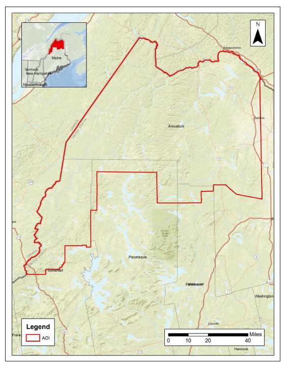
This project encompasses the northern portion of Maine and covers 6,732 square miles. LiDAR data was captured and processed to meet USGS Quality Level 2 (QL2) accuracy standards. Approximately 2/3 of the project was acquired in the spring of 2018, but due to sensor issues and leaf-out conditions, the middle portion of the project was not captured in 2018, but in the spring of 2019. Actual date ranges are from May 12, 2018 through June 8, 2019.
The State of Maine serves derivative products (Digital Elevation Model (DEM), and contours in the near future) from this dataset and they are available through the Maine GeoLibrary Data Catalog (https://www.maine.gov/geolib/catalog.html#elevation).
The LiDAR point cloud data will be made available through The National Map (TNM) and the United States Interagency Elevation Inventory (USIEI) sites by the end of the year (estimated).
Two-foot contours in vector format are also part of this Crown of Maine deliverable and will be made available in the mid-October timeframe. Stay tuned for an updated announcement on delivery and availability dates.
Sincerely,
Claire Kiedrowski Executive Director
Maine Library of Geographic Information
GeolibraryBoard.OIT@maine.gov
December 27, 2019
GeoLibrary Special Meeting: Discuss LD1719 on 1/6/2020 @ 4 PM EST
Dear Geospatial User,
The Maine Library of Geographic Information will hold a special Board Meeting on Monday, January 6, 2020 at 4:00 PM EST to discuss and vote on Legislative Document 1719 prior to the legislature's early January meeting. LD1719 "establishes a Task Force to study the changes required to modernize the acquisition, maintenance, storage and distribution of geographic data in Maine". The draft legislative document is attached along with the Agenda. We welcome your feedback on this issue.
We will also be electing our Board Chair, since this is the 1st meeting of the year.
This public meeting will be held at:
Maine Public Utilities Commission (PUC)
Room: TBD
101 2nd St, Hallowell, ME 04347
You do not need to attend in person to participate. Feel free to forward this announcement to other interested parties. Your emailed comments are also welcome (my contact information is below).
We have a dial-in number for Audio, and a separate Skype link for Viewing capabilities.
For Audio: Dial In (877-455-0244 x:367-352-2033#)
For Visual: Click link below:
Join Skype Meeting
Trouble joining? Try Skype Web App
Note that we will be holding our regularly scheduled Board Meeting on Wednesday, January 15, 2020 at 10 AM EST at the PUC. Call in number and Skype link are the same.
If you have any questions or comments, or need help connecting to the meeting, contact me and I will assist you.
Sincerely, Claire
Claire Kiedrowski
Executive Director
Maine Library of Geographic Information
Cell:(207) 266-7087
Email: claire.kiedrowski@maine.gov
Web: https://www.maine.gov/geolib/
LI: https://www.linkedin.com/in/clairekiedrowski/
August 20, 2019
Orthoimagery 2018 Dynamic Re-Projection Inaccuracy UPDATE
Hello Maine GeoLibrary Data Consumers,
UPDATE: Maine GeoLibrary Orthoimagery 2018 dynamic reprojection inaccuracy has been corrected by applying applicable transforms to our services. For reference, the native projection is http://www.epsg-registry.org/export.htm?wkt=urn:ogc:def:crs:EPSG::6348, https://epsg.io/6348
July 29, 2019
Orthoimagery 2018 Dynamic Re-Projection Inaccuracy
Dear Geospatial User,
*****NOTICE: Dynamic reprojection of Maine GeoLibrary Orthoimagery 2018 in some environments, including ArcGIS Online Web map, may display inaccurately. The approximate value of the observed inaccuracy is one meter displaced southerly. The cause of this error has been determined and a fix is scheduled for Sunday August 4, 2019. NOTICE*****
Thank you for your patience while this issue is resolved.
Sincerely,
Todd Metzler
Maine Office of Information Technology GIS Platform Administrator; Maine GeoLibrary Board Technical Committee Advisor
June 26, 2019
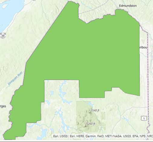
Crown of Maine LiDAR Update
Dear Geospatial User,
Good news: the "Crown of Maine" LiDAR acquisition was completed in late May and early June. You may recall that this project was not completed in 2018 due to sensor and weather issues, but I am pleased to let you know that between the original acquisition in 2018 and this spring's acquisition in 2019, we now have a complete dataset for this area:
The processed and edited dataset is scheduled to be delivered to USGS in late 2019, with an anticipated delivery to the State of Maine in early 2020.
You can also track the status here: https://www.maine.gov/geolib/programs/lidar/index.html
I will keep you updated as the project progresses.
Sincerely, Claire
Claire Kiedrowski
Executive Director
Maine Library of Geographic Information
Cell:(207) 266-7087
Email: claire.kiedrowski@maine.gov
Web: https://www.maine.gov/geolib/
LI: https://www.linkedin.com/in/clairekiedrowski/
May 29, 2019
Subject: Update on 2019 Maine Orthoimagery Program
Good afternoon, I have news to share with you on the 2019 Maine Orthoimagery program! Please see the image below for a status on the 2019 Program. Note that the color of the flight line indicates the following:
? ORANGE = Not flown
? GREEN = Passed Quality Control
? RED = Re-flight needed
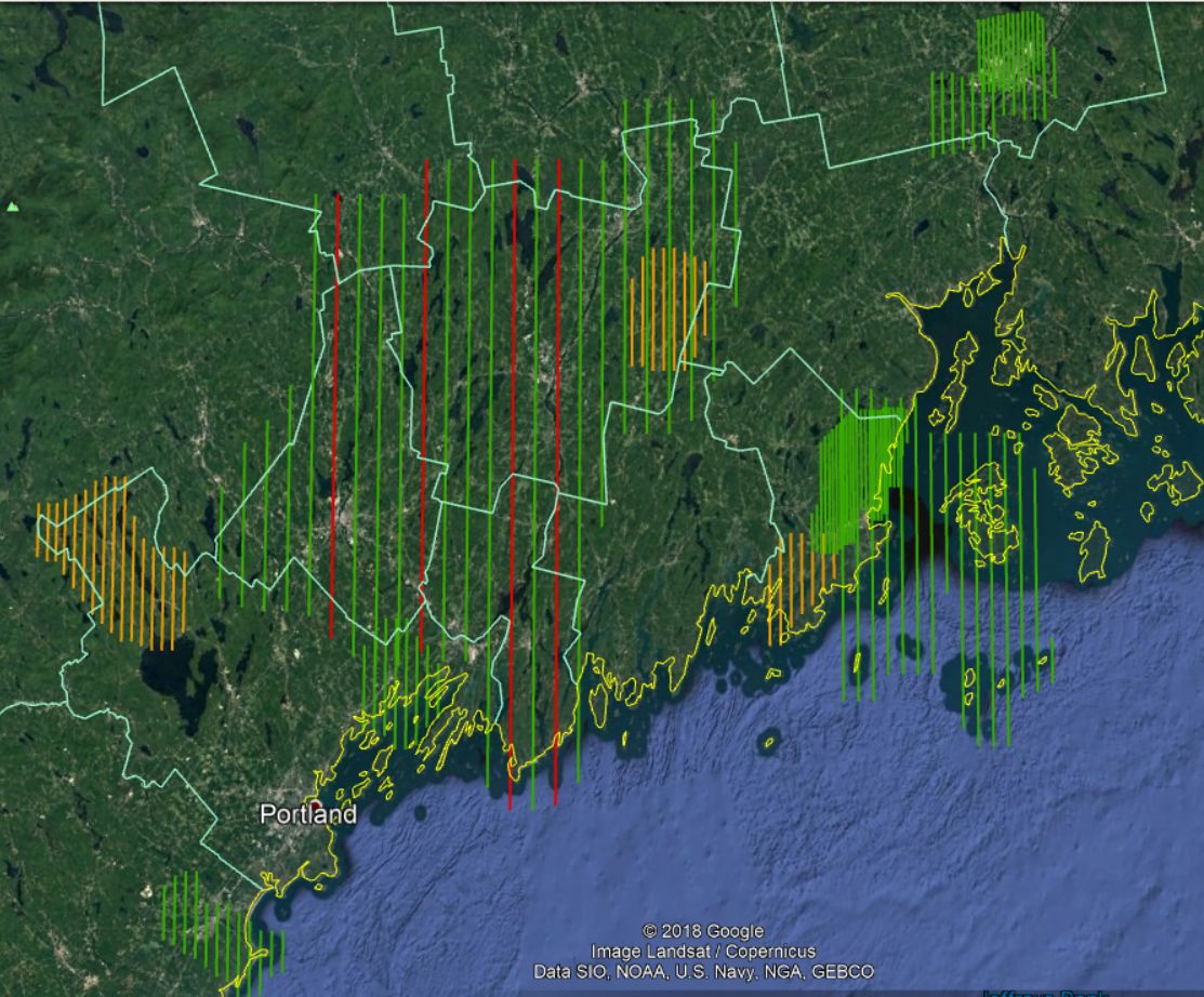
These communities were flown for 4-band orthoimagery this past May under ideal leaf-off, minimal snow conditions:
? 3" ? Bangor, Camden, Rockport, Thomaston
? 6" ? Biddeford, Brewer, Hampden, Freeport*
? 12" ? Knox County
? 18" ? Androscoggin, Kennebec, and Sagadahoc Counties**
*Due to weather and ground conditions, we were not able to capture suitable imagery for Bridgton, Naples, China, or Cushing, but they are all scheduled for next Spring 2020.
** A few areas for the 18" county acquisitions may need to be re-flown due to clouds, cloud shadow and other (even though the entire line is shown in red indicating a re-flight, it really is just specific areas). These are minimal issues and will be addressed during the Quality Control process. If needed, impacted tiles will be re-flown during the Spring 2020 acquisitions and updated tiles will be delivered.
May 29, 2019
Subject: New Maine GeoLibrary Executive Director
I am pleased to let you know that I have been hired as the new Executive Director for the Maine GeoLibrary. This is a part-time, contract position through my current employer Cornerstone. I am excited to step into this role and honored to represent the Board. I have another email address where you can reach me for Maine GeoLibrary concerns, which is listed below. I monitor both email addresses, so feel free to contact me using either account. Cell phone is the same.
Claire Kiedrowski
Executive Director
Maine Library of Geographic Information
Cell:(207) 266-7087
Email: claire.kiedrowski@maine.gov
Web: https://www.maine.gov/geolib/
LI: https://www.linkedin.com/in/clairekiedrowski/
May 20, 2019
Subject: Maine GeoLibrary Service and Data Catalog Update May 2019 Number 2
Hello GIS service and data consumers. Below are Maine GeoLibrary and Maine Office of GIS service URL CHANGES effective May 20, 2019. OLD service links will be REMOVED on June 9, 2019.
Item 1
Description: Maine GeoLibrary Orthoimagery Project 2012
Category: imageryBaseMapsEarthCover
NEW: https://gis.maine.gov/arcgis/rest/services/imageryBaseMapsEarthCover/orthoRegional2012/ImageServer
OLD: https://gis.maine.gov/arcgis/rest/services/megis/ortho2012ImgSvc/ImageServer
Item 2
Description: Maine GeoLibrary Orthoimagery Project 2013
Category: imageryBaseMapsEarthCover
NEW: https://gis.maine.gov/arcgis/rest/services/imageryBaseMapsEarthCover/orthoRegional2013/ImageServer
OLD: https://gis.maine.gov/arcgis/rest/services/megis/ortho2013ImgSvc/ImageServer
Item 3
Description: Maine GeoLibrary Orthoimagery Project 2014
Category: imageryBaseMapsEarthCover
NEW: https://gis.maine.gov/arcgis/rest/services/imageryBaseMapsEarthCover/orthoRegional2014/ImageServer
OLD: https://gis.maine.gov/arcgis/rest/services/megis/ortho2014ImgSvc/ImageServer
Item 4
Description: Maine GeoLibrary Orthoimagery Project 2015
Category: imageryBaseMapsEarthCover
NEW: https://gis.maine.gov/arcgis/rest/services/imageryBaseMapsEarthCover/orthoRegional2015/ImageServer
OLD: https://gis.maine.gov/arcgis/rest/services/megis/ortho2015ImgSvc/ImageServer
Item 5
Description: Maine GeoLibrary Orthoimagery Project 2016
Category: imageryBaseMapsEarthCover
NEW: https://gis.maine.gov/arcgis/rest/services/imageryBaseMapsEarthCover/orthoRegional2016/ImageServer
OLD: https://gis.maine.gov/arcgis/rest/services/megis/ortho2016ImgSvc/ImageServer
Item 6
Description: Maine GeoLibrary Orthoimagery Project 2017
Category: imageryBaseMapsEarthCover
NEW: https://gis.maine.gov/arcgis/rest/services/imageryBaseMapsEarthCover/orthoRegional2017/ImageServer
OLD: https://gis.maine.gov/arcgis/rest/services/megis/ortho2017ImgSvc/ImageServer
Please visit https://www.maine.gov/geolib/index.html. We welcome your feedback. https://www.maine.gov/geolib/contactus.html
Sincerely,
Todd Metzler
Maine Office of Information Technology GIS Platform Administrator; Maine GeoLibrary Board Technical Committee Advisor
January 8, 2019
Raster Data Migration - mapserver.maine.gov retired
On Friday January 4, 2019, the portion of our legacy GIS Enterprise hosting much of our raster data was shutdown. All content that had been hosted at http://mapserver.maine.gov continues to be accessible in the Maine GeoLibrary Data Catalog at https://maine.hub.arcgis.com .
These same data and services may also be accessed directly via a web browser, GIS/CAD client or programmatically at https://gis.maine.gov/arcgis/rest/services . Users choosing to access data services directly from the REST service directory should recognize the use of ISO 19115 Topic Categories for folders containing services. Looking for orthoimagery? Explore the imageryBaseMapsEarthCover folder; Contours? Explore the Elevation folder.; Parcels? Explore planningCadastre folder; etc.
October 24, 2018
mapserver.maine.gov shutdown date Nov 11, 2018
Web GIS Services migrated to https://gis.maine.gov/arcgis/rest
http://mapserver.maine.gov and http://mapservertest.maine.gov will be SHUT DOWN on November 11, 2018.
Imagery and elevation services have been migrated to https://gis.maine.gov/arcigs/rest
All applications consuming MapServer-based services should be updated before the shutoff date.
The migrated data layers can be discovered and accessed in the GeoLibrary Data catalog: https://maine.hub.arcgis.com/
Imagery and elevation downloads are available at:
https://www.maine.gov/geolib/imgdiscovery/site/landing.html (imagery)
and
https://www.maine.gov/geolib/ediscovery/site/landing.html (elevation data)
October 22, 2018
Google Chrome Incompatability with GeoLibrary web applications
Please note that the Geolibrary Image Discovery Application and Elevation Data Discovery Application will not function in Google Chrome. Please use a different browser with these apps.
October 12, 2018
Update on Maine GeoLibrary Board
Dear Geospatial User,
Many of you are aware that Joseph Young, Executive Director of the Maine GeoLibrary Board and Administrative Director of the Maine Office of GIS for several years, retired in August 2018. The intent was for him to continue in a role as a consultant during a transition period, but those plans have changed.
The Board will continue to support the Orthoimagery, LiDAR, and other geospatial data programs. If you have questions regarding access to GeoLibrary data on the Board's website please contact the State of Maine, Office of Information Technology Help Desk (oit.customer-support@maine.gov, phone 207-624-7700). For administrative issues, please contact Brian Guerrette (brian.guerrette@maine.gov, phone 207-624-3335).
Please contact these individuals for more information regarding plans for supporting GeoLibrary programs:
- Jon Giles, Chairman of the GeoLibrary Board
- Phone office: 207-200-2128
- Email: jgiles@sebagotechnics.com
- Claire Kiedrowski, GeoLibrary Board Member
- Phone office: 207-942-5200, x350
- Phone cell: 207-266-7087
- Email: ckiedrowski@cornerstoneenergyinc.com
- Brian Guerrette, Office of Information Technology
- Phone office: 207-624-3335
- Email: brian.guerrette@maine.gov
Sincerely,
Claire Kiedrowski
Maine GeoLibrary Board Member