
Road Information
Get Water Away from a Road
- Drainage cannot be emphasized enough in road construction and maintenance. Water affects the entire serviceability of a road. Too much water in the base materials weakens the road. Water allowed to remain on top of a gravel or paved road weakens the surface and, when combined with traffic, causes potholes, cracking, and rutting. If improperly channeled, water causes soil erosion and breakdown of pavement edges. Whether it's mud in the spring or frost heaves in winter, the presence of water in roads is nothing but trouble.
- Building and maintaining a good surface drainage system and maintaining it is the best way to lessen water's damaging influence on a road. A proper surface drainage system prevents water from infiltrating the pavement's surface and removes water from the driving lanes in a constant thin sheet to the side ditches which carry the water away from the roadway. Sealing cracks in the pavement surface also helps but this is of little use if the surface drainage system does not function properly. A surface drainage system has four components: road crown, shoulders, ditches and culverts. The crown or superelevation of the road surface allows water to run off to the side ditches.
- Shoulders are an extension of the road surface and allow for the continued flow of water to the ditches. Ditches are used to carry water away from the roadway. They need to be kept clean and protected from erosion. Water left in the ditch can sometimes leak back into the pavement's foundation materials. Water collected and carried in the ditch has to be directed away from the roadway at frequent intervals, sometimes using culvert pipe. Culverts usually channel water from one side of the road to the other, helping to control the flow of water and slowing it down to reduce erosion.
- Road managers are guided by the principles that 1 water runs down hill, 2 water needs outlets at the bottom of all grades, and 3 puddles mean problems. If it were not for water, a road commissioner's job would be easy. But because of water, whether in liquid form or as snow or ice, a road manager's work is never done. Except for some moisture that is needed for soil compaction and for dust control, water is the road manager's enemy.
Build on a Firm Foundation
- A highway wears out from the top but it falls apart from the bottom. This is another way of saying that the road base determines the service life of a road. The base supports everything above it, including traffic. If adequate support does not exist, the road will rapidly deteriorate. A good road requires a suitable foundation which, in turn, requires stable material. A road material is stable if it has little or no change in its volume and does not deform under repeated loads whether the material is wet or dry.
- Soils can be stabilized using such agents as asphalt, calcium chloride, cements, lime, salt and other products. To select the proper stabilizing agent, an understanding is required of both the soil and the agent to be used. The additive must be of the correct type and in the correct quantity to produce satisfactory results. Geotextiles may also be very helpful to stabilize a soft road.
Use the Best Soils Available
Roadway Gravel in Maine (PDF)
- In Maine, natural good-quality gravel is getting to be in short supply. Blended or crushed gravels are more expensive alternatives. The quality of soils used by a town will often depend on local availability and budget. In deciding what is affordable, a town should consider the long-term consequences of using lower quality material. By putting down a good base in the beginning using quality materials, a town can correct the few weak spots in the roads over a period of years and be assured of a sound base upon which eventually to apply a permanent hard surface.
- Using inferior base materials may require excessive maintenance during the road's life and perhaps costly rehabilitation before paving. The adage "pay me now or pay me later" applies to road building.
- Written guides exist to help road commissioners classify the usefulness of soil types for road foundations and bases. The guides give information on potential frost action, compressibility, and drainage characteristics.
Compact Soils Well
- The denser the materials, the stronger the base. When soil is improperly compacted, future traffic loads or changes in moisture content can cause settlement and failure of the roadway. Compaction is achieved by pressing soil particles together using rollers, tampers, or vibrators, expelling the air from the mass, filling the spaces between the particles, and making the material more dense.
- Well-graded soils having a fairly even distribution of particle sizes will compact more easily than poorly-graded soils having mostly one particle size. Jagged or semi-jagged particles will compact to a more stable configuration than rounded particles of similar size. A certain amount of moisture is necessary for good solid compaction.
Design for Winter Maintenance
If a town designs its roads for winter maintenance, they would be adequate for the remainder of the year. Consider the following:
- A one-way plow cuts a nine-foot-wide swath. If the road is wide enough to allow the plow and a school bus to meet, it is wide enough during the remaining seasons of the year.
- If ditches and roadside areas are wide enough to store snow, chances are they will accommodate spring thaws and heavy water flows.
- A town will not be sorry for having a wide road but it may regret building a narrow one.
- Grades should be a minimum of one percent for drainage purposes but should not be greater than ten percent, if at all possible. If the road is steeper than that, it is difficult for heavy equipment to maneuver, especially in wintertime.
- Sight distance should be considered in designing a road. For safety's sake, a driver should be able to see 75 to 100 feet up the road for every 10 miles of speed. This rule of thumb may be helpful when issuing permits for driveways onto a town road.
Build for Traffic Volumes and Traffic Loads
- Ice on a pond will support a young skater but it will crack under the weight of an automobile or even break apart. Similarly, a road built to serve residential traffic will break down when it starts carrying a number of large trucks. It takes the passage of approximately 9,600 cars to equal the effect on a road of the passage of one 80,000-pound truck. Road commissioners know that roads, like bridges, should be designed with the expected traffic type and volume in mind.
- A rule of thumb is to design a road to accommodate the largest vehicle that will use the road under normal operations. Designing the road for the largest piece of town equipment which maintains it in all kinds of weather may suffice. To determine the required depth of base, a common guide is to put in �-inch to one inch of gravel for every foot of traveled way width. For example, a 20-foot-wide roadway should have a minimum of a 15- to 20 inch gravel base.
- When considering the type and thickness of pavement mixes to apply on a gravel road, a town is wise to seek some advice. Generally speaking, a low-volume road (300 vehicles per day or less) having some truck traffic may provide good service with a "chip seal." The main function of such a seal is to eliminate the need to replace and reshape gravel, eliminate dust and to prevent raveling of soils. As traffic volumes and weights increase, the type and thickness of pavement should increase to a point where the pavement itself actually shares the load stress. Heavy-duty Interstate highways, for example, have a foot or more of asphalt concrete below the riding surface.
Pave Only Those Roads that are Ready
- In their haste to put a smooth surface on a gravel road, some towns make the mistake of paving over a road that is not properly prepared. The result may be a complete waste of money. Unless the base of the road is first built with the proper thickness for the traffic it must bear and the gravel is compacted to a proper density with the ability to drain well, any pavement put on it will fail. Experienced road commissioners make sure a gravel road works well before paving. The cost of reconstructing a failed road is must higher than doing it right the first time.
Build from the Bottom Up
- A road that has a poor base and poor drainage cannot be adequately improved with a top dressing of gravel or new pavement. It may be necessary in some cases to dig out the old road, put in new material and build up the road in layers. Before doing anything to correct a road surface problem, road managers should take into consideration what is causing the problem underneath. Improper drainage, insufficient depth of base or poor quality gravel may be the culprits. These should be corrected before spending money on the surface.
Protect Your Investment
If worn roof shingles are not replaced and if the outside is not painted occasionally, a house will deteriorate and lose value. Roads and bridges also need regular maintenance to keep them from deteriorating. The increased weight and frequency of traffic on Maine roads combined with our adverse weather conditions, mean an increased rate of road and street deterioration. Regular road and bridge maintenance preserves our road investment and prevents costly major rehabilitation later on.
Maintenance activities include:
- Roadway Surfaces - blading and shaping, patching, resurfacing; dust control; snow and ice removal
- Drainage - cleaning and repairing culverts and ditches
- Roadside - cutting brush, trees and grass; repair and prevention of roadside erosion
- Bridges - channel clearing; repair of rails, decks and structure; cleaning and painting
- Traffic Services - sign maintenance
- Special Projects - restoration or improvements; emergency work such as removing slides and repairing retaining walls.
Keep Good Records
- Road commissioners know their roads like the back of their hand. Most of them are a walking history book when it comes to the roads they manage every day. This knowledge is of little use, however, when the road commissioner is laid up or retires.
- Good record keeping makes roadwork much easier for everybody. It's easier to draw up budgets and to show citizens plans for roadwork. Recording what type of work was done on a road or bridge, when, and what materials were used can help a lot in decision-making later on.
- Towns can start by inventorying all roads and bridges, listing length, width, surface types, culverts, problem areas and other items. Putting these items on a map helps. Next comes listing and prioritizing needed improvements, putting a price tag on them and knocking off a few problems each year. Good record keeping of road and bridgework and equipment is good business. Several user-friendly software programs exist to help towns in this effort, and are available at the Maine Local Roads Center at 1-800-498-9133.
- Common Answers to Gravel Road Questions (Video)
- Gravel Road Maintenance and Design Manual (PDF)
- Material Testing Firms (PDF)
- Minimizing Mud Problems in the Spring (PDF)
- Model Grading Specifications for Roads (PDF) (DOC)
- Dust Control a 2010 study of 5 commercial products pg 4,5 (PDF)
- Handy Reference Article on Calcium Chloride Application Rates and Handling (PDF)
- Erosion and Sediment Control Law
- DEP site on forming a Road Association
- DEP site on Camp Road maintenance
- Paved vs Gravel Road Maintenance Costs- a Study by the Town of Richmond (PDF)
- Should a paved road revert back to being gravel?
- “ Depaving paved roads ” from “Hot Mix Asphalt Technology” magazine, May/June 2011, pages 36-39 www.hotmix.org
- “ Gravel resurfaces ” from “Roads and Bridges” magazine, April 2011, page 42 "Gravel Resurfaces" Article (PDF)
- “ Weighing the options ” from “Better Roads” magazine, April 2011, page 12
- When should I Pave a Gravel Road? (PDF)
- When to Pave a Gravel Road?(PDF)
Developing a Legal Road Inventory
Developing a Road Management Plan
 Do you have a written “road plan” to plan for and fund future road repairs? A road budget is an easy target to “save money” in tight budget times but any wise road manager will recognize that putting off repairs will just cost more money in the long run with more significant repairs.
Managing a local road budget and determining which road gets fixed can be a very daunting task…… and be controversial.
The Center has developed some inexpensive and easy-to-use software which can provide the basis or background to making these decisions on how/what/how much/where repairs will be done across a community. Many municipalities across Maine and other states have used this software to develop and support a road budget. In many cases, the software has been used to justify some relatively large road bonds. While this software is not a highly technical analysis of a road network, it is very powerful, low cost, and easy-to-use by any level of computer user. If your community wants to take a highly technical approach to road planning with deterioration rates and pavement condition index numbers, there are several other more expensive products on the market.
RSMS software is ready to help your town pave the way to better roads, less complaints and a mechanism for preparing a sustainable budget. RSMS was developed as a collaboration between TC2 Consulting Services and Maine Local Roads Center. It is designed to be an efficient and effective tool for road and drainage management. This tool will enable municipalities to develop a quality road plan with minimal manual effort.
There are 2 software products available from the Center: RSMS16 (available to Maine users only) and RSMS11 (available to anyone)
Managing a local road budget and determining which roads gets fixed can be a very daunting task…. and spark some hearty discussion at a Town Meeting. One satisfied municipal manager stated:
"Our road network is in awful shape and we're going to need a bunch of money to fix it. We purchased RSMS because we've heard it is the easiest, fastest, and least expensive way to develop a credible, professional road plan to make our case why we need funding."
RSMS has helped hundreds of municipalities raise significant funding to fix their road network; one town called us the day after a Bond Issue vote and said they raised $23,000,000 using RSMS!
How did your roads get in their current condition? Someone did not observe the principle on which RSMS is founded. Keep your good roads good. Just like maintaining your car or home or roof or lawn mower……it’s cheaper to maintain it than it is to forget it and then have to buy a new car or roof!
The chart below illustrates the life cycle of a road. It starts its life smooth and black, but inevitably begins to deteriorate, based on various aspects of the road’s construction including the condition of the base, the quality of drainage, traffic volume, and gross vehicle weight.
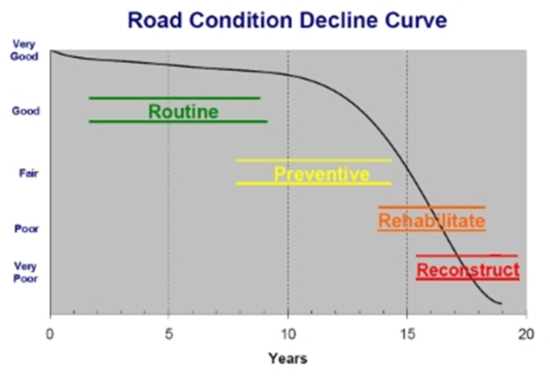
As a road ages, the rate at which it deteriorates escalates until the end of its’ life cycle. If no maintenance is performed, the road will need to be rebuilt, costing significant time and money. Repair costs also increase in a non-linear fashion as demonstrated on the graph.
Roads are an asset. Like all assets they must be managed. The most effective way to do this is with a road plan. RSMS software is an easy way to develop a road plan and also serves as a tool for historical record-keeping.
What is a Road Plan?
A road plan must be objective, consistent with municipal priorities, and easily defensible with stakeholders; the residents and taxpayers who drive and fund the road network.
A road plan is a formal document that provides answers to the following questions:
- What condition is our network in?
- Which roads are a higher priority?
- What is the right repair?
- What will it cost?
- What is the history of work and expenditures on each road?
RSMS provides tools that makes the process of plan development not only possible, but relatively easy.
Steps to a Road Plan
- Collect data (inventory and surveys) and record in RSMS. RSMS has the capacity to store documents and pictures of roads to enhance your inventory.
- Run reports to verify accuracy of road inventory
- Run Network Overview graphical charts
- View Network Overview charts and begin to develop priorities
- Choose road treatments from a list of appropriate recommended repairs, develop schedule, and budget
- Run financial reports to review budget and adjust as needed
- RSMS comes loaded with state DOT pricing for items, i.e. gravel, but you can add your own local repair costs
- After work is performed, enter actual costs and detailed notes including documents (such as contracts) and pictures
Overview
RSMS 16 is an easy to use GIS software to manage your roads and traffic signs. This powerful and visually attractive tool can assist town managers, road commissioners, public works directors, road committees, and budget committees to develop a prioritized maintenance plan for their road network. This software includes the ability to assess and inventory both paved and gravel roads. It includes an optional sign management module where a town can inventory and assess all of its road signs. (It is not available to non-Maine agencies because we do not have access to that GIS map data)
History
RSMS 16 was launched in 2016. It was designed to be an enhanced successor to RSMS 11 with a GIS (map-based) user interface so that all road conditions are visually shown in color coded patterns of your local roads. It also includes a sign assessment module that ultimately shows the number of signs and their conditions.
Features
Specific design features of RSMS 16 include:
- Starting with a customized map of your local road inventory
- Easy to learn and use
- Easy to generate useful outputs in an attractive format
- Showing all road conditions and sign conditions on a color coded map
- Insightful road network analysis and planning without requiring road engineering know-how
- Usable by all levels of municipal officials, road committees, and other stakeholders
Overview
RSMS 11 was originally designed to provide an easy, yet powerful tool to assist local officials develop a prioritized maintenance plan, with costs, for their paved and unpaved road network. The basic steps include developing a road inventory, then conducting a condition assessment from a vehicle, then reviewing the repair strategies and costs One can then review the results of several reports and a bar chart that summarizes all the miles into 5 repair strategies….. with costs.
For Maine communities, it is highly recommended to use RSMS16 instead to take advantage of its mapping features.
For other non-Maine communities, RSMS 16 is not available as we do not have your mapping data. You will need to use RSMS11.
Features
Specific design features of RSMS 11 include:
- Provide insightful road network analysis and planning without requiring road engineering know-how
- Easy to learn and easy to use
- Easy to generate useful outputs in an understandable format
- Usable by all levels of municipal officials, road committees, and other stakeholders
RSMS 16
Maine municipalities.....$195.00
Maine municipalities upgrading from RSMS 11.....$100.00
Nonmunicipal businesses....$495.00
RSMS 11
Maine municipalities.....$100.00
Out of State municipalities.....$150.00
Nonmunicipal businesses.....$495.00
For more information or to purchase RSMS please contact:
Tammy Sobiecki
MaineDOT, Local Roads Center (LTAP)
16 State House Station
Augusta, ME 04330
(207) 624-3265 direct line
or Email Tammy
“Pavement preservation” is defined as “is a program employing a network level, long‐term strategy that enhances pavement performance by using an integrated, cost-effective set of practices that extend pavement life.” Simply put, it is about doing the right thing on the right road at the right time. It’s being proactive and not reactive to road conditions.
In March 2021, the Center conducted a one hour virtual program entitled “Stretching Budgets with Pavement Preservation”. It was provided by Bobby Betsold from All State Materials Group (ASMG) and focused on the importance of a road plan and the effective use of various treatment strategies at the right time in a pavement’s life. Rather than simply paving a road every “x” years, there are many other alternative methods to preserve pavement at a much lower price.
Here are the session materials:
- Powerpoint slide program (PDF) and (PPT)
- One hour recorded video from 3/11/2021
- Local road Network value (XLS) – use your town’s paved and gravel road mileage to determine its rough value. It only values pavement and gravel and not culverts, guardrail, striping, etc.
- Treatment Comparison & Network Approach (XLS) —use the different strategies by adding miles into each to set up a budget……it reinforces the concept of “keeping the good roads good” and not spending all your road money using the “worst first…fix it first” approach
 As the Pine Tree state, Maine is largely covered by trees and most of our 22,800+ miles of public
roads have trees along them. Knowing that many motor vehicle fatalities and injuries occur when a
vehicle leaves the road and hits a tree, the MaineDOT and municipalities have the authority to control
their rights-of-way and provide safer roadsides. That translates into the laws related to trees within
a road's right-of-way (which is typically wider than the actual paved or gravel travelway).
As the Pine Tree state, Maine is largely covered by trees and most of our 22,800+ miles of public
roads have trees along them. Knowing that many motor vehicle fatalities and injuries occur when a
vehicle leaves the road and hits a tree, the MaineDOT and municipalities have the authority to control
their rights-of-way and provide safer roadsides. That translates into the laws related to trees within
a road's right-of-way (which is typically wider than the actual paved or gravel travelway).
- Determining ownership is the first step in the process when trees are in a public right of way.
- The owner of a tree is the landowner on whose land the tree is rooted.
- A very large percent of state-and town-maintained roads are not owned by the state or town (they are easements). Ownership belongs to the adjacent property.
- Along those few “fee highways” in Maine, the state or town actually owns that land through an acquisition process and it includes the air above and the earth below.
- If a trunk is split by a property boundary, the tree is owned by both parties. Decisions should be made by mutual consent of both parties.
- Whoever OWNS the right-of-way, OWNS the trees.
- Owners are responsible for preventing hazards that their trees may present, including to the travelling public. They may be held accountable if the tree causes property damage, bodily harm, or death.
- MaineDOT and municipalities may remove hazardous trees that pose a serious threat to the travelling public without landowner permission.
- The owner has “first right of refusal’ for the wood.
- A municipality’s obligation to keep town ways “safe and convenient” includes the duty to remove roadside brush, trees and grass that could pose a road safety problem. Uncontrolled brush can limit sight distances and in some cases may intrude onto the travel way itself.
- The municipality may at its expense remove healthy or dead trees located within the right of way if they pose a safety hazard to the traveling public or impede the municipality’s ability to maintain the road.
- On a local road, if a tree is located in the right-of-way but is not (in the determination of the municipal officers or road commissioner) a safety hazard, then the municipality is under no duty to remove it, even if the abutter requests removal.
- If the reason for removing the tree is to protect an abutter’s house or property, rather than the traveling public, then the abutter should pay the costs of removal.
- Trees located outside the road right of way should not be removed by the municipality without the landowner’s permission.
- The municipality may cut any limbs in the air or roots on the ground that intrude into the right of way, even if the trunk of the tree is outside the right of way.
- Consider appointing a tree warden, budgeting, and planning for removals. Write an action plan.
- Always work with the landowner.
- If in doubt on state roads, contact MaineDOT’s Gustave Norhstein at (207) 441-4521 or by emailing him directly.
Maine law governs trees in Title 30-A, Chapter 157, Subchapter 4. Some of the highlights are:
- All trees within or upon the limits of any highway are public shade trees (Section 3281).
- All public shade trees may be under the care and control of conservation commissioners in municipalities which appoint those commissioners under this subchapter. The conservation commissioners may have the powers and duties of tree wardens in regard to those trees (Section 3263).
- The municipal officers of municipalities which have not appointed conservation commissioners under subchapter II may annually appoint one or more tree wardens who have the care and control of all public shade trees upon and along the highways and in the parks of the municipality and all streets within any village limits. They shall enforce all laws relating to the preservation of those trees (Section 3282).
- Public shade trees may be trimmed, cut down or removed by the owner of the land only with the consent of a tree
warden or the conservation commission. Public shade trees may be trimmed, cut down or removed
by a tree warden or conservation commissioner only with the consent of the landowner (Section
3283). However, this section does not prevent the trimming, cutting or removal of trees when
the trimming, cutting or removal is ordered by proper authority to:
- Lay out, alter or widen the location of highways;
- Lessen the danger of travel on highways; or
- Suppress tree pests or insects.
 Signs in
the right-of-way of public roads are covered under state law found in Title 23, �1913-A.
Signs in
the right-of-way of public roads are covered under state law found in Title 23, �1913-A.
See paragraph L for details about spacing and maximum time periods. Please note that the Legislature passed LD 209, as Public Law Chapter 321 on 2/18/2018 that will 1) change the 6 weeks to 12 weeks and, 2) creates a date the sign was erected. This becomes effective on August 1, 2018.
For specific details, contact MaineDOT"s Susan Merriman at susan.merriman@maine.gov or call her at 207/624-3332.
Any modern public road in Maine should be built to certain minimum standards that consider the traffic volume, type and size of vehicles, presence of pedestrians or bicycles, and overall safety to all road users.
- For subdivisions roads:
The Southern Maine Regional Planning Commission (SMRPC) developed a set of “ Model Subdivision Regulations ” in the 90’s and they were updated in 2007. They are primarily for subdivision design and review. - For low volume local roads:
AASHTO has a manual entitled “Guidelines for Geometric Design of Low-Volume Roads (ADT less than 2000), 2nd edition, 2019.” This very handy manual references recommended ranges of values for dimensions such as road widths, horizontal and vertical alignments, sight distances, etc. The manual can be found here and costs $122 for a non-member PDF copy; however, the Center has a copy of the 1st Edition if you ever wanted to review it first or needed specific information. - The Center has also developed a road “cross section” that graphically shows the “desirable minimum dimensions” of a low volume local road: Desirable Minimum Dimensions (PDF)
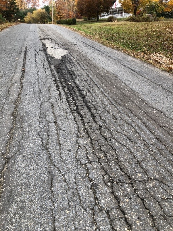
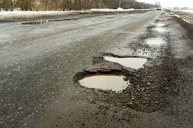
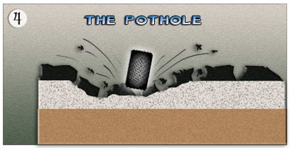
Potholes begin after moisture seeps into the native soil below the road surface and subbase gravel. This moisture comes in the form of rain, snow or water seeping into the road bed due to poor roadside drainage.
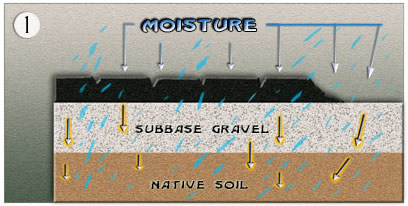
As the temperatures drop ice lenses of frozen water form,causing the ground to expand and push the pavement up as this is the direction of least resistance.
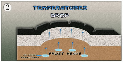
As the temperatures rise, the ground returns to normal level but the pavement often remains elevated above the once frozen area. This creates a cavity between the pavement and the material below it.
When motor vehicles travel over this cavity, the pressure exerted on the unsupported pavement surface cracks after numerous impacts of vehicles traveling over the cavity. Finally the pavement crumbles and falls into the cavity, leading to a pothole.
- Maine law regarding Dig Safe
- Dig Safe website: This site has all the information you need to properly make “excavations” in Maine along with using 8-1-1 or their “quick ticket” system.
- Grading gravel roads: a shoulder grading activity is now well defined and provides a method
for this activity to occur without being in direct conflict with the law. Before this change, any
grader blade which came closer than 18 inches in depth to the buried utility line was automatically
in violation. Now, it is allowable ONLY IF the following occurs:
- the excavator calls Dig Safe and all other nonmembers, as usual,
- the excavator contacts each utility operator in the grading area and describes the proposed grading activity and includes the expected depth of grading,
- within 3 days of this contact, the utility operator determines and notifies the excavator whether the faciltity is deep enough to avoid damage,
- after this discussion, the excavator can grade the shoulders so as not to disturb the facility.
- if the facility is not deep enough to allow the grading activity, the licensing authority (town or state, as applies), may require the utility operator to lower or otherwise move its facility in accordance with state law or its license, before the shoulder grading occurs.
- Installing street name signposts
- Street name signs and posts for E-911: Because the installation of sign posts is considered an "operation in which earth, rock, or other material BELOW the ground is moved or otherwise displaced," municipalities should call DIGSAFE before installing these posts. You can either call them with the locations (e.g., northwest corner of Elm and Maple Street) OR FAX the list to them at 781-721-0047. They will then assign authorization numbers to each site and FAX the list back to you. (Don't forget to premark the sites!)
- Some people have questioned their liability if installing sign posts by hand or by power equipment. State law specifies that the use of power tools or equipment requires DIGSAFE notification. Digging, pounding, or trenching with hand tools is NOT considered excavation. However, what happens when road crew member Brutus drives a U-channel sign post with a sledgehammer right through a fiber-optic cable? Liable or not? State law says no, but this would probably create some interesting discussion between several attorneys. The bottom line is: make the free phone call, especially if you suspect any possibility of underground facilities.