DACF Home → Bureaus & Programs → Maine Geological Survey → Maps, Publications and Online Data → Using Geologic Maps → Inner Continental Shelf Maps
Surficial Geology of the Maine Inner Continental Shelf 1:100,000-scale Maps Description
What is the surficial geology of the inner continental shelf?
The surficial materials of the inner continental shelf of the northwestern Gulf of Maine are the most complex of any place along the Atlantic continental margin of the United States. Igneous, metamorphic, and sedimentary rocks spanning hundreds of millions of years of earth history form the regional basement. Glacial deposits, containing all clast sizes from boulders to mud, partially mantle the rocks. These materials, in turn, have been reworked by coastal processes during extreme fluctuations of sea level over the past few thousand years to create better-sorted modern deposits. Biological processes, including shell formation, bioturbation, and organic matter cycling have also altered the sediment composition and left geological imprints on the seafloor.
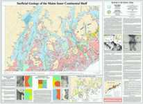
Surficial Geology of the Maine Inner Continental Shelf Maps
This map series shows the surficial geology of the Maine inner continental shelf. Color map units showing seafloor type were determined using side-scan sonar surveys, seismic reflection profiles, grab samples, cores, and video images. Bathymetry is shown with 10 meter (33ft) contours from National Ocean Service provisional Bathymetric and Fishing maps. Latitude and longitude coordinate grids are plotted in 10 minute increments, and the territorial sea boundary is also shown. Geographic names on the map include some coastal towns and cities, prominent islands, bays, harbors, and peninsulas. Major roads and inland lakes and streams are provided for reference. An explanatory text describes the regional geologic setting, scientific methods used, description of seafloor types, geologic history, summary of seafloor types, and sources of additional information. Maps are 4 feet wide and 3 feet high. The area covered by each map is one degree of longitude by half a degree of latitude. The scale of the maps is 1:100,000 or one inch equals approximately 1.6 statute miles or 2.5 kilometers.
Uses of inner continental shelf information
The maps in this series provide a broad overview of the seafloor along the coast of Maine. They illustrate the complex characteristics of bathymetry and bottom types for a variety of marine uses. Information on these maps can be of value in identifying seabed habitats, sand for beach nourishment, dredged material disposal sites, unstable sites with subsurface biogenic gas deposits, shipwreck sites, potential cable or pipeline routes, and sites for offshore wind farms or aquaculture. The maps are not intended for navigational use, but they can supplement other information in selecting anchorages.
How to obtain or view these maps
Use the Maps and Publications Search to identify printed and online publications available from the Maine Geological Survey. You can search for maps and publications by geographic area or subject. Search results are linked to online publications. To order printed materials see the ordering instructions.
Last updated on July 15, 2015