Home → Bureaus & Programs → Bureau of Parks and Lands → Find Parks & Lands → Park Details
Description
Please check for access and COVID-19 updates by using this link to the Bureau's Safety page
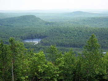
Kennebec Highlands Public Land has the highest peaks in Kennebec County, including the summit of McGaffey Mountain, plus miles of pristine streams, several wetlands, and five undeveloped ponds. It is the largest contiguous block of conserved land in central Maine, and one of the few areas in the region with the potential for landscape-scale conservation. Managed collaboratively with the 7 Lakes Alliance, formerly the Belgrade Regional Conservation Alliance, the Highlands are part of 15,000 acres of relatively undeveloped forest and wetland habitat. It is the only forest block of its size, quality, elevation, and bedrock diversity in the central part of the state, proximate to population centers, and having substantial portions already preserved. All of these features are critical to the water quality of the Belgrade Lakes Watershed.
History
In 1998, the Belgrade Regional Conservation Alliance, now the 7 Lakes Alliance, initiated a project to protect the Kennebec Highlands area in Rome, Mount Vernon, Vienna, and New Sharon, Maine. The Kennebec Highlands' 6,800 acres contain the highest peaks in Kennebec County, including the summit of McGaffey Mountain, miles of pristine streams, several wetlands, and five undeveloped ponds. The Kennebec Highlands provides trails and open space based recreation close to numerous population centers.
The Land for Maine's Future program has been a strong financial supporter of the Kennebec Highlands project through four rounds of financing. Phase I and II of the project protected 5,500 acres for public use and habitat. Phase III included the summit of McGaffey Mountain, the highest peak in Kennebec County, and added 1,011 acres to the Highlands. Phase IV added another 283 acres bringing the total amount of protected land to 6,800 acres. The Land and Water Conservation Fund (LWCF) also played a key role in the 2022 acquisition of the Allen Blueberry fields parcel and the LWCF will be an important source of additional funding to support new parking, roads, and trails to accommodate visitors. In each of these phases, local financial support and foundation funding have been critical to raising the cash match for these acquisitions.
Activities
- ATV riding
- Cross-country skiing
- Fishing
- Hiking (trails)
- Hunting
- Mountain biking
- Snowmobiling
- Snowshoeing
- Watchable wildlife
Rules
- Collection - All Cultural objects must be left undisturbed on all State Lands. Additionally, within Critical Areas, Forest Preserves and other designated sites for educational and scientific purposes, such areas and objects are to be left undisturbed.
- Fires - Are not allowed.
- Pets - Must be attended and under control at all times.
- Fishing - All those fishing must have a valid license and review the State's open water fishing regulations. Anglers are asked to use lead-free sinkers and jigs to prevent metal poisoning of loons, eagles and other wildlife. FMI: www.maine.gov/ifw
- Hunting - Althought hunting is permitted, loaded firearms are not permitted on hiking trails. Do not discharge weapons within 300 feet of any picnic area, parking area, marked hiking trail or other developed area. For hunting seasons and regulations visit www.maine.gov/ifw
Consider lending a hand. Contact us if you would like to help with stewardship or maintenance work.