Home → Bureaus & Programs → Bureau of Parks and Lands → Find Parks & Lands → Park Details
 Maine Trail Finder
Description
Please check for access and COVID-19 updates by using this link to the Bureau's Safety page.
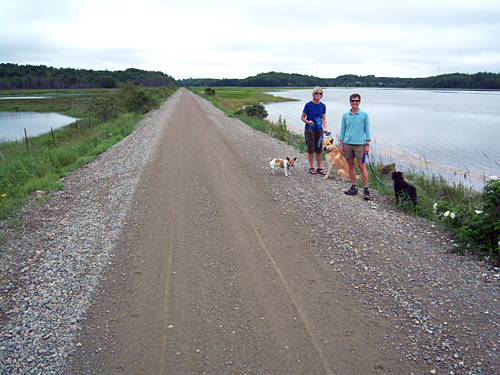
The Down East Sunrise Trail (DEST) is an inter-agency project of the Maine Department of Transportation (Maine DOT) and the Maine Department of Agriculture, Conservation and Forestry. The project has rehabilitated 87 miles of the Calais Branch rail corridor for possible future rail use while at the same time providing a wide compact gravel-based trail for immediate use. The DEST is managed for use by snowmobilers, ATV-ers, pedestrians, bicyclists, cross-country skiers, equestrians, and other outdoor enthusiasts.
87 miles of multi-use trail is open for permanent year-round use from Ellsworth east to mile post 87, Ayers Junction in Pembroke (except for mud season).
For Current Trail News & Notices please check:
- Snowmobile Trail Notices and News
An Overview Page and three Section Maps have been produced that highlight on and near trail features with the help of a grant from the Maine Outdoor Heritage Fund (MOHF) and the Recreational Trails program (RTP).They are available for download here:
DEST Overview Page (.pdf 201KB / 8-1/2x11-inch format)
Washington Junction to Cherryfield, 28 miles (.pdf 556KB / 8-1/2x11-inch format)
Cherryfield to Machias, 29 miles (.pdf 251 KB 8-1/2x11-inch format)
Machias to Ayers Junction, 28 miles (pdf 262 KB 8-1/2x11-inch format)
Enjoy the trail and please remember it is multi-use; motorized users must yield to non-motorized and please demonstrate courtesy and ethics to all trail users as well as abutting landowners.
The Sunrise Trail Coalition (STC) is the supporting nonprofit membership organization which acts as the management committee working with the Bureau's DEST Trail Manager. For information about the STC, membership forms, and the latest activity updates and photos of the trail, visit the website: www.sunrisetrail.org
If you are interested in learning about geology around the state, check out the Maine Geological Survey Searchable Database.
History
The Calais Branch railroad corridor is 127 miles long and connects Brewer to Calais in Downeast Maine. It was acquired by the Maine Department of Transportation in 1987 from Maine Central Railroad for the purposes of rail preservation and has been unused by the rail operators since that time.
Activities
- ATV riding
- Cross-country skiing
- Dog sledding
- Hiking (trails)
- Horseback riding
- Off-road biking
- Snowmobiling
- Snowshoeing
- Watchable wildlife
Rules
- Motorized users must yield to non-motorized users of the trail.
- See Rules for State Parks and Historic Sites
Consider lending a hand. Contact us if you would like to help with stewardship or maintenance work.
Trails
ATV Trail Condition Updates & News
Snowmobile Trail Condition Updates & News
The scenic rail corridor runs along the entire Downeast coastal area, connects multiple scenic conservation areas, intersects Downeast salmon rivers, and is very near two state scenic byways.
The multi-use trail brings economic and recreational benefits to the Washington and Hancock County areas similar to other trails in Central and Northern Maine. Just some of the benefits include people visiting area attractions, staying at local hotels, and visiting local restaurants.
DIRECTIONS TO THE PARKING AREAS
Washington Junction Parking Lot, Hancock - From Ellsworth: take Main Street east from junction with US 1A, US 1, and Route 3. Go 2.5 miles. Turn left on Railroad Street. From the east travelling on US 1: Two miles west of Route 182 junction turn right on the road that directs you to the Ellsworth Hospital. Travel 2 miles. Turn right on Railroad Street.
Franklin/Route 182 Trailhead - Parking where the Down East Sunrise Trail intersects Route 182 in the center of Franklin.
Route 183/Tunk Lake Road Trailhead - Turn north off US 1 in Sullivan on the Tunk Lake Road/Route 183. Travel 4 miles. Park where the trail intersects Route 183.
Cherryfield Parking at Matthews Grocery or at North Street Cafe - North Street Cafe is at 109 North Street in Cherryfield. From US 1 take Route 193 north for about 1 mile. Turn left on North Street at Mathews Grocery (Parking available). Coming east on Route 182 turn left at North Street just after crossing the Trail.
Columbia Falls/Tibbettstown Road - Turn north from US 1 on the Tibbettstown Road. Park where the Trail crosses Tibbettstown Road less than a block from US 1.
Machias (US 1) - Parking at green boxcar and Station 98, just west of the causeway (dike). Also, parking is allowed on the causeway (no trailers).
East Machias (US 1)- Turn east off US 1 on to Willow Street. Large parking lot to the left behind Archibold’s One-Stop Gas Station, next to Downeast Salmon Federation (DSF) Aquatic Research Center.
East Machias (Route 191) - Seven miles north of intersection of US 1 and Route 191 in a gravel lot on the west side of Route 191 where the Trail intersects roadway.
Dennysville (Route 86) - On Route 86, 1 mile west of the intersection of US 1 and Route 86 in Dennysville, turn north on Milwaukee Road. Go 100 feet to gravel parking lot on right where Trail intersects roadway.
Ayers Junction (Route 214) - On Route 214, 4 miles northwest of intersection of US 1 and Route 214 in Pembroke. The gravel parking lot is on the left at intersection of the tracks and the roadway.
Services and Facilities
Special Considerations
All motorized vehicles permitted on multi-use trails must be legally registered as either an ATV and/or snowmobile.
When to Visit
Year round access except for mud season.