Home → Bureaus & Programs → Bureau of Parks and Lands → Find Parks & Lands → Park Details
 Land for Maine's Future
 Land and Water Conservation Fund
 Maine Trail Finder
Description
Please check for access and COVID-19 updates by using this link.
Location Lat 44.907186 / Lon -67.010662
Off Route 190 in Eastport.
Hours / Season Open all year; 9:00 a.m. to sunset daily unless otherwise posted at the gate. Fee Charged. - cash or check only, no credit cards accepted.
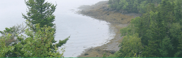
Close to downtown Eastport, the easternmost city in the United States, Shackford Head State Park encompasses 90 acres on Moose Island overlooking Cobscook Bay. This promontory at the entrance to Cobscook Bay encircles the west side of Broad Cove.
Several miles of trails cross the headland. A hiking trail from the parking area leads through woods to a rocky headland 173 feet above sea level, passing several pocket beaches and protected coves. From this outlook, visitors can see Campobello Island in New Brunswick, Canada, the town of Lubec, and the Eastport cargo pier on Estes Head, as well as aquaculture pens where Atlantic salmon are raised. Park trails afford great opportunities for wildlife watching as well - with warblers and hermit thrushes in the woodland areas, and bald eagles, common terns and spotted sandpipers along the shore. Ornithologists have documented 28 different bird species nesting on the headland.
Read the May 9, 2019 Rubys on the Road review of the park.
Read about the geology of Shackford Head State Park. Learn about the geology of the area on the interactive Maine Geologic Facts and Localities map.
Land for Maine's Future This property was acquired in part with funds from the Land for Maine's Future program. For more information about the LMF program and the places it has helped to protect, please visit the LMF webpage.
The Land and Water Conservation Fund contributed to this State Park.Learn more about LWCF.
History
Shackford Head is named for one of the town's earliest settlers, Capt. John Shackford - a Revolutionary War soldier who arrived with his family about 1783. Born and raised in Massachusetts, he spent most of his 87 years based in Eastport. Capt. Shackford owned the headland and used Broad Cove as his ship's anchorage. He died December 25, 1840 and is buried beside his wife in the nearby Hillside East Cemetery.
During the early 1900s, five ships that had served in the Civil War (the U.S.S. Franklin; U.S.S. Minnesota; U.S.S. Richmond, U.S.S. Vermont and U.S.S. Wabash) were burned for salvage (recovery of brass and iron) at Cony Beach on Shackford Head. A memorial plaque on site provides more details about this chapter in the headland's history.
In the 1970s, Shackford Head was the site of a proposed oil refinery that the Pittston Company sought to construct - a plan that met with strong opposition due to Cobscook Bay's navigational hazards and exceptional wildlife values. When the property came up for sale in 1988, the Eastport Land Trust sought assistance from the State's Land for Maine's Future (LMF) Program to keep the land wild for the public to enjoy. The LMF Program helped fund its acquisition in 1989 and the Maine Department of Conservation now owns and manages the land.
If you are interested in learning about geology around the state, check out the Maine Geological Survey Searchable Database.
Activities
- Hiking (trails)
- Picnicking
- Watchable wildlife
Rules
- Please stay on trails to protect the headland's fragile vegetation. Be careful near cliffs and water (due to the great tidal range, water can move up the shore quickly).
- Park rules strictly prohibit use of intoxicating beverages.
- No hunting, camping or motorized vehicles are permitted.
- Do not feed, touch or disturb wildlife.
- Keep pets on leash (length of 4 feet or less) at all times.
- Carry out all trash.
- While swimming is allowed along other beaches at Shackford Head, it is not recommended at Cony Beach (just east of the parking area) as that was the demolition site of the Civil War ships.
- See Rules for State Parks and Historic Sites
Consider lending a hand. Contact us if you would like to help with stewardship or maintenance work.
Trails
The interconnected trail system at Shackford Head State Park includes some easy walking trails and some more challenging, uneven terrain (particularly on the Ship Point and Schooner trails). Trails near the parking area provide some access for wheelchairs but the entire trail network is not accessible. Enjoy the fine overlooks but use care near high cliffs and bluffs. The best shore access is at Cony Beach (by the parking area) or from the Broad Cove Trail.
The Shackford Head Overlook (1.2-mile roundtrip) provides good views of Cobscook Bay and environs. If you enjoy challenging terrain, add on the Ship Point Trail (an additional half-mile loop) and return to the parking lot via the Schooner Trail for a total of roughly 2 miles.
Note: When eagles are nesting on park lands, certain trails may be temporarily closed to protect young eagle families from disturbance. Please respect signs posting trails as closed.
For more information about this trail you may also visit the Shackford Head State Park trail map at Maine Trail Finder.
Tours and Programs
View the Maine Parks and Lands EVENT CALENDAR
Services and Facilities
Special Considerations
Shackford Head State Park is not routinely staffed. Please take extra precautions when you visit as there is no ranger assistance close by. Wear sturdy footwear and be prepared for uneven terrain. Supervise children closely when walking on cliffside trails or near shore.
The Park is often wreathed in fog that forms when warm, moist air from the mainland meets masses of cold air over the surrounding waters. Pack extra layers of clothing, be prepared for low visibility and carry a park map when hiking. Please take note of park boundary signs and do not trespass on adjacent property.
Tides along the shoreline can fluctuate more than 20 feet and flow in quickly - so keep an eye on the water when exploring the shore.
Carry your own drinking water for hikes and picnics as none is available at the park.
For your protection, do not leave valuables unattended in your vehicle.
In late spring and summer, be prepared for some mosquitoes and black flies. Deer ticks, while not prolific, do inhabit the area so check yourself daily to prevent Lyme disease.