Home → Bureaus & Programs → Bureau of Parks and Lands → Find Parks & Lands → Park Details
 Maine Trail Finder
 Northern Forest Canoe Trail
Description
Keep informed with Bureau Safety Updates.
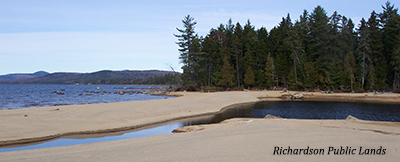
Located in the scenic Rangeley Lakes Region of western Maine, the 22,000-acre Richardson Unit includes 21 miles of shoreline on Richardson and Mooselookmeguntic Lakes, as well as frontage on several small ponds. Covering 1,900 acres, the Bald Mountain Unit offers views of the surrounding mountains and lakes. The big lakes and small ponds, bounded by hardwood ridges and softwood flats, attract those who enjoy boating, fishing, hiking, and camping in a remote setting near the mountains.
Access to the southern portion of Richardson Public Land is by the South Arm Road. Boat access campsites on Richardson Lake are managed by reservation with South Arm Campground (207) 364-5155. Route 16 passes through the northern section known as "Upper Richardson". For more information please contact the Western Region Public Lands Office at (207) 778-8231.
Richardson and Mooselookmeguntic Lakes are part of the Northern Forest Canoe Trail. The Northern Forest Canoe Trail is an historic 740-mile watertrail through New York, Vermont, Quebec, New Hampshire, and Maine.
If you are interested in learning about geology around the state, check out the Maine Geological Survey Searchable Database.
Activities
- ATV riding
- Boating (motorized)
- Camping
- Canoeing
- Cross-country skiing
- Fishing
- Hiking (trails)
- Hunting
- Snowmobiling
- Snowshoeing
- Swimming
- Watchable wildlife
Rules
Consider lending a hand. Contact us if you would like to help with stewardship or maintenance work.
Services and Facilities
- Picnic area
- Trailered boat launch
- See Visitor Accessibility
Special Considerations
Moving firewood can transport exotic insects & diseases that pose a serious threat to our forests. Don't transport firewood, buy it from a local source. Burn It Where You Buy It Out-of-State firewood is banned.
When to Visit
Open All Year.