Home → Bureaus & Programs → Bureau of Parks and Lands → Find Parks & Lands → Park Details
 Appalachian Trail
 Land for Maine's Future
 Land and Water Conservation Fund
 Maine Birding Trail
 Maine Trail Finder
Description
Be Prepared for Your Visit - check the Bureau's Safety Page.
Location Lat 44.572106 / -70.902701 for Screw Auger Falls Parking Lot; On Route 26 near the New Hampshire border and approximately 14 miles north of Bethel.
Hours / Season Open 9:00 a.m. to sunset daily from May 15 to October 15. Fee charged. - cash or check only, no credit cards accepted.
Off Season Visitors may continue to enjoy the park during the off season during these same hours. Please place the admission fee in the self-service collection canister. Please be aware that facilities are closed during the off season. See the When to Visit section at the bottom of this page for more details.
Sightseeing and backcountry hiking amidst spectacular peaks and gorges await you!
Grafton Notch State Park and the Mahoosuc Public Lands are a premier recreational destination lying amidst some of Maine's most spectacular mountains the Mahoosuc Range. These lands offer rugged terrain for backcountry hikers and include 12 of the most challenging miles along the entire Appalachian Trail. Hikers who negotiate the steep summit trails are rewarded with spectacular views, particularly on Old Speck (4,180 feet).
Those who seek tamer adventures can find short walks leading to impressive waterfalls and gorges. The renowned Grafton Notch Scenic Byway bisects the Park and several pull-offs highlight interesting natural features. In Grafton Notch State Park, part of the Maine Birding Trail, birdwatchers can observe peregrine falcons, a wide variety of songbirds, and - at higher elevations - northern forest species. At lower elevations, visitors commonly observe large mammals, even in the vicinity of Route 26. Hunters come in search of deer, bear and grouse, while fishermen try their luck for brook trout in many area streams.
In winter, snowshoers, cross-country skiers and snowmobilers enjoy exploring the lands. The popular snowmobile route ITS 82 runs across this region from Andover to New Hampshire's Trail 18.
The Mahoosuc Public Lands contain a 9,993-acre Ecological Reserve designated by the State to sustain sensitive ecosystems in their natural condition and provide for monitoring of ecological changes over time. The Reserve includes a sub-alpine tarn, Speck Pond, and several rare plant and animal species. The Maine Bureau of Parks and Public Lands manages portions of the Mahoosuc Public Land Unit for timber production (in addition to other benefits). The timber management practices are certified sustainable and help support the costs of maintaining Public Lands.
Read the July 11, 2019 Rubys on the Road review of the park.
Partners and Supporters
This land was conserved with support from the Maine Bureau of Parks and Lands, the Trust for Public Land, Open Space Institute, U.S. Forest Service Forest Legacy Program, Land for Maine's Future Program, Mahoosuc Land Trust, and many other contributors.
Through a cooperative agreement with the Maine Bureau of Parks and Lands, the Appalachian Mountain Club maintains the AT south of Route 26 and the Maine Appalachian Trail Club maintains the stretch north of Route 26.
Popular Stops Along Route 26
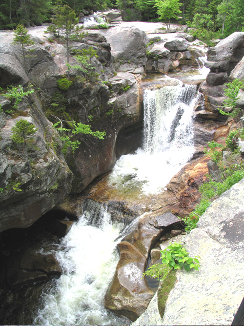
Screw Auger Falls: A walking path from Route 26 leads to this 23-foot waterfall lying in a narrow gorge along the Bear River. Many visitors enjoy wading in the shallow pools, but supervise children closely and avoid the lip of the falls.
Mother Walker Falls: This V-shaped gorge, named for a long-time local resident, is more than 40 feet and 980 feet long. It's a short walk from Route 26: supervise children closely.
Moose Cave: In this 200-foot-long gorge, lying within a 45-foot-deep canyon in the bedrock, water skirts boulders and disappears temporarily into a cave beneath a huge granite slab. The loop trail to Moose Cave, off Route 26, is a quarter-mile long with some narrow spots and steep slopes.
Spruce Meadow Picnic Area: Lying in the park's northern portion, this picturesque setting offers tables (with grills) overlooking a wildlife-rich marsh and Old Speck Mountain.
Sustainable Forest Management on Maine's Public Lands Grafton Notch State Park and the Mahoosuc Public Lands offer a fascinating glimpse into Maine's geologic history and provide an ongoing demonstration of the power water has to shape the landscape. Metamorphic bedrock dating back roughly 420 million years is evident in some settings (like the summit of Old Speck).
Grafton Notch itself is a classic example of a U-shaped valley carved out by glacial action during the last ice age. Some higher mountain ledges still carry striations (grooves) left by the glacier, and many places have accumulations of sand and gravel outwash left by glacial meltwater.
The glaciers retreated from this area roughly 12,000 years ago. Today erosion still continues - as water moves stones that scour out potholes and weak spots in the underlying rock.
For a guided tour of the park's geologic highlights, see Geology of Grafton Notch State Park. Learn about the geology of the area on the interactive Maine Geologic Facts and Localities map. Consider lending a hand. Contact us if you would like to help with stewardship or maintenance work. Route 26 (Appalachian Trail) Trailhead
Sustainable forest management is one of the many principal land management activities that take place on Maine's Public Reserved Lands. Scientifically-based timber harvests are planned in coordination with recreation, wildlife, forest health, and scenic considerations. Revenues from certified sustainable forestry timber sales support the management and maintenance of trails, campsites, roads and other infrastructure and wildlife management projects.
History
Activities
Rules
Trails
The parking area along Route 26 (with pit toilet, trail register and brochures) provides access to day hiking and overnight backpacking. Both the Appalachian Trail (AT) and the Grafton Loop Trail (which spurs off the AT both north and south of the Rt. 26 trailhead) provide backpacking opportunities. Popular day hikes include the Table Rock Trail and the AT (to the summit of Old Speck).
Grafton Loop Trail: (38 miles, 3 or more days, challenging) is a high-elevation, backcountry trail with seven primitive campsites, connecting a series of nine scenic peaks, such as Old Speck, Sunday River Whitecap, Puzzle Mountain, and East and West Baldpate. The route in the northern sections of the loop follows the AT, though the majority of trail is relatively new construction made possible by hundreds of volunteers, numerous partners, and the gracious support of private landowners (significant sections of the trail cross private land). Note: the Grafton Loop Trail also intersects Rt. 26 further south near the Eddy Rd. in North Newry. There is designated parking on the eastern side of Rt. 26 by the trailhead for Puzzle Mt. The trailhead for the southwestern portion of the Grafton Loop Trail can be reached by walking approximately 0.75 miles south on Rt. 26 from the parking area.
West Side of Route 26
Old Speck Trail: (7.6 miles, 7 hours, challenging) Old Speck affords spectacular views from an open observation tower at the summit. Follow the white-blazed Appalachian Trail south along Cascade Brook. The trail crosses many streams then ascends the north shoulder, rising out of the woods and offering frequent views of the Notch. The summit and tower are reached via a 0.3-mile spur reached at approximately 3.5 miles from the trailhead. The Grafton Loop Trail continues on from the summit, descending southeastward.
Eyebrow Loop Trail: (2.2 miles round trip, 2-3 hours, challenging) rises steeply to an "eyebrow" shelf/overlook on Old Speck Mountain at 2,900 feet. Follow the white-blazed Appalachian Trail south for 0.1 miles to the start of the orange-blazed Eyebrow Trail. Passing through a stand of magnificent hardwoods, the trail rises gently until it reaches the steeper precipice section. Portions of the orange-blazed ascent involve ladders/steel rungs: the descent following the Appalachian Trail is steep but involves no climbing. Those wishing to avoid the rungs and ladders can go up and back the AT portion for a 2.6-mile roundtrip. The Eyebrow may not be suited for small children, especially in wet conditions. Natural Heritage Hike for Eyebrow Loop and Appalachian Trail Natural Heritage Hikes are narratives that guide hikers through the rich ecological, geological, and cultural elements encountered on 25 of Maine's most popular hiking trails. These descriptions provide the hiker with the what, how, and why of the natural environments they are walking through. View all Natural Heritage Hikes.
East Side of Route 26
- Picnic area
- See Visitor Accessibility
Table Rock Loop Trail: (2.4 miles round trip, 2 hours, moderate) Cross Route 26 and follow the white-blazed AT. After 0.1 miles, you can choose between the steep, boulder-strewn, orange-blazed Table Rock Trail (not appropriate for pets or young children) or continue on the moderately steep AT to the next trail junction. After approximately one mile, the blue-blazed Table Rock trail begins (offering an easier hike for less experienced hikers). Table Rock, 900 feet above your starting point, offers fantastic views to Old Speck, the Eyebrow and Grafton Notch. Take care at the summit as there is a steep drop-off where the ledge ends and no fencing.
Baldpate Mountain Trail: (5.8 miles round trip to West Peak; 7.6 miles round trip to East Peak; allow 7 hours round trip; challenging) Cross Route 26 and follow the white-blazed Appalachian Trail north, crossing Route 26. Entering the Mahoosuc Public Lands, the trail ascends steadily across the north slope to the open summit of West Baldpate (elevation 3, 680 feet). Turning north, the trail loses only 240 feet in altitude before climbing to East Peak, nearly a mile beyond. East Peak (elevation 3, 812 feet) offers outstanding views in all directions.
Appalachian Trail: (20+ miles, 4 days, challenging) Some of the most challenging sections of the entire AT lie along the 18 miles of the Trail that fall within Grafton Notch State Park and the Mahoosuc Public Lands. The trail tends to be steep and boulder-strewn as it follows ridgelines through the Mahoosuc Range. The most difficult stretch lies between Full Goose Lean-to and Speck Pond Lean-to. Hikers who attempt this stretch should be well conditioned and equipped. Refer to the AMC Maine Mountain Guide and/or �
Tours and Programs
View the Maine Parks and Lands back to top)
Services and Facilities
Special Considerations
The region's abundant large animals can create hazards: drive slowly on area roads (particularly in low light) and make sure that tents and their contents are free of food and food odors.
Don't count on your cell phone in an emergency as coverage is spotty to non-existent.
Potable water is not available at the Park (except at Spruce Meadow Picnic Area) so bring your own. Purify any water from brooks or ponds.
Winter users can park in the lot off Route 26 or the twin bridges on the Sunday River Road.
Expect fast-changing weather, especially at higher elevations. Snow comes early and stays later in the mountains.
Safety Precautions for Hikers:
Register in the trail log and tell someone where you're heading and when you expect to return.
Stay on marked trails, particularly in sensitive areas such as alpine summits and wetlands.
Wear sturdy hiking boots and carry extra clothing, food and water: be prepared for sudden changes in weather.
Confirm estimated hiking times, allow sufficient daylight hours, and turn around if you discover the trail is beyond your ability.
Supervise children closely, particularly on mountain trails and near gorges.
Stay below the tree line in lightening storms: lightening strikes are common on mountaintops.
Travel & Camp on Durable Surfaces. Many mountainous areas are particularly sensitive to erosion and disturbance: please help sustain the spectacular beauty of this setting.
Remain on trails at all times;
Camp only at authorized sites and keep campsites as small as possible; and
Walk on bare rock rather then on plants (when on ledges and summits).
When to Visit
Hikers enjoy the area through warm-weather months, and many visitors come in fall for the spectacular foliage.
During winter, hardy cross-country skiers and snowshoers explore ungroomed trails and snowmobilers enjoy lower elevation trails.